
Francois Peron National Park is a national park on the Peron Peninsula in Western Australia, 726 km north of Perth, and located within the boundary of the Shark Bay World Heritage area. The nearest towns to the park are Denham, which is found on the southern edge of the park and Carnarvon which is found about 80 kilometres (50 mi) to the north.
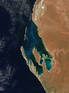
Shark Bay is a World Heritage Site in the Gascoyne region of Western Australia. The 23,000-square-kilometre (8,900 sq mi) area is located approximately 800 kilometres (500 mi) north of Perth, on the westernmost point of the Australian continent. UNESCO's official listing of Shark Bay as a World Heritage Site reads:
The Gascoyne region is one of the nine administrative regions of Western Australia. It is located in the north west of Western Australia, and consists of the local government areas of Carnarvon, Exmouth, Shark Bay and Upper Gascoyne. The Gascoyne has about 600 km (370 mi) of Indian Ocean coastline; extends inland about 500 km (310 mi); and has an area of 135,073.8 km2 (52,152.3 sq mi), including islands.

North West Coastal Highway is a generally north-south Western Australian highway which links the coastal city of Geraldton with the town of Port Hedland. The 1,300-kilometre-long (808 mi) road, constructed as a sealed two-lane single carriageway, travels through remote and largely arid landscapes. Carnarvon is the only large settlement on the highway, and is an oasis within the harsh surrounding environment. The entire highway is allocated National Route 1, part of Australia's Highway 1, and parts of the highway are included in tourist routes Batavia Coast Tourist Way and Cossack Tourist Way. Economically, North West Coastal Highway is an important link to the Mid West, Gascoyne and Pilbara regions, supporting the agricultural, pastoral, fishing, and tourism industries, as well as mining and offshore oil and gas production.

The Shark Bay Marine Park is protected marine park located within the UNESCO World Heritage–listed Shark Bay, in the Gascoyne region of Western Australia. The 748,725-hectare (1,850,140-acre) marine park is situated over 800 km (500 mi) north of Perth and 400 kilometres (250 mi) north of Geraldton.

Denham is the administrative town for the Shire of Shark Bay, Western Australia. At the 2016 census, Denham had a population of 754. Located on the western coast of the Peron Peninsula 831 kilometres (516 mi) north of Perth, Denham is the westernmost publicly accessible town in Australia, and is named in honour of Captain Henry Mangles Denham of the Royal Navy, who charted Shark Bay in 1858. Today, Denham survives as the gateway for the tourists who come to see the dolphins at Monkey Mia, which is located 23 kilometres (14 mi) northeast of the town. The town also has an attractive beach and a jetty popular with those interested in fishing and boating.

The Carnarvon xeric shrublands is a deserts and xeric shrublands ecoregion of Western Australia. The ecoregion is coterminous with the Carnarvon Interim Biogeographic Regionalisation for Australia (IBRA) bioregion.

Coral Bay is a small coastal settlement located 1,200 kilometres (750 mi) north of Perth, in the Shire of Carnarvon in the Gascoyne region of Western Australia.
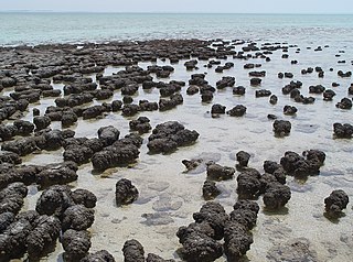
The Hamelin Pool Marine Nature Reserve is a protected marine nature reserve located in the UNESCO World Heritage–listed Shark Bay in the Gascoyne region of Western Australia. The 127,000-hectare (310,000-acre) nature reserve boasts the most diverse and abundant examples of living marine stromatolites in the world, monuments to life on Earth over 3,500 million years BP.
Shark Bay Airport is an airport located on the Peron Peninsula within the Shark Bay World Heritage site in the Gascoyne region serving Monkey Mia, a resort in Western Australia, and the nearby town of Denham.
Western Australia has the longest coastline of any state or territory in Australia, at 10,194 km or 12,889 km. It is a significant portion of the coastline of Australia, which is 35,877 km.
ABC Pilbara is an ABC Local Radio station based in Karratha. Formerly known as ABC North West WA, the station broadcasts to the Gascoyne and parts of the Pilbara regions of Western Australia. This includes the towns of Port Hedland, Carnarvon, Exmouth, Newman and Tom Price.
Peron Peninsula is a long narrow peninsula located in the Shark Bay World Heritage site in Western Australia, at about 25°51' S longitude and 113°30' E latitude. It is some 130 kilometres (81 mi) long, running north-northwesterly, located east of Henri Freycinet Harbour and west of Havre Hamelin and Faure Island. It is the largest of the Shark Bay peninsulas. Significant settlements include Denham and Monkey Mia. An airport is located there. It is the location of former Pastoral leases Peron and Nanga stations. It is the main location of land access to points within the World Heritage site. The northern area contains the Francois Peron National Park. It is surrounded by the Shark Bay Marine Park and its lower southeast part is adjacent to the Hamelin Pool Marine Nature Reserve.

Warroora or Warroora Station is a pastoral lease that once operated as a sheep station and is now operating as a cattle station in the Gascoyne region of Western Australia. The property offers eco friendly accommodation to tourists with visitors able to stay in the old homestead, shearers' quarters or camping near the beach.
Middalya Station is a pastoral lease that operates as a sheep station in Western Australia.
Tourist Drives in Western Australia are routes through areas of scenic or historic significance, designated by route markers with white numbers on a brown shield. Tourist Drives were introduced into Western Australia while Eric Charlton was the state government Minister for Transport in the 1990s. The 28 numbered routes collectively traverse more than 2,000 kilometres (1,200 mi) across the state. In addition to the Tourist Drives, there are unnumbered routes such as the Golden Pipeline Heritage Trail, and local governments may designate and maintain local scenic drives, generally unnamed and unnumbered.
Main Roads Western Australia controls the major roads in the state's Mid West region. There are four main highways through the Mid West: The north-south coastal route of Brand Highway and North West Coastal Highway, the inland alternative Great Northern Highway, and the northern section of Goldfields Highway, which links Meekatharra with Kalgoorlie. A network of main roads connects towns within the Mid West to each other, the highways, and neighbouring regions, with local roads providing additional links and access to smaller townsites. Roads are often named after the towns they connect.
Main Roads Western Australia controls the major roads in the state's Pilbara region. There are two main highways in the region: Great Northern Highway, which travels north through the region to Port Hedland and then north-west along the coast, as well as North West Coastal Highway, which heads south-west from Port Hedland. A series of main roads connects towns to the highways, and local roads provide additional links. The majority of these roads service the western half of the region, with few located in the various deserts east of the Oakover River. Roads are often named after the towns or areas they connect.
Main Roads Western Australia controls the major roads in the state's Kimberley region. Great Northern Highway is the major road connection through the region, with sealed roads spurring off it to connect to population centres, and unsealed roads offering an alternative route between Derby and Wyndham.
Main Roads Western Australia controls the major roads in the state's Goldfields-Esperance region. While the region is the state's largest, the major roads are restricted to the region's western and southern edges. From the major population centres of Kalgoorlie and Coolgardie, Great Eastern Highway heads west towards Perth via the Wheatbelt ; Coolgardie–Esperance Highway leads south to the port of Esperance via Norseman; and Goldfields Highway proceeds north to Wiluna and then on to the Mid West Region. From Norseman, Eyre Highway takes interstate traffic east across the Nullarbor Plain and into South Australia.