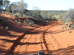
The Gunbarrel Highway is an isolated desert track in the Northern Territory, South Australia and Western Australia. It consists of about 1,350 km (840 mi) of washaways, heavy corrugations, stone, sand and flood plains. The Gunbarrel Highway connects Victory Downs in the Northern Territory to Carnegie Station in Western Australia. Some sources incorrectly show the highway extending west to Wiluna.

Leonard Beadell OAM BEM FIEMS was a surveyor, road builder, bushman, artist and author, responsible for constructing over 6,000 km (3,700 mi) of roads and opening up isolated desert areas – some 2.5 million square kilometres – of central Australia from 1947 to 1963. Born in West Pennant Hills, New South Wales, Beadell is sometimes called "the last true Australian explorer".

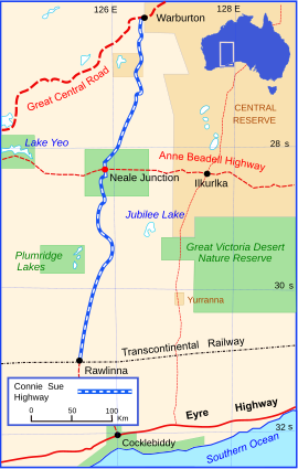
Anne Beadell Highway is an outback unsealed track linking Coober Pedy, South Australia, and Laverton, Western Australia, a total distance of 1,325 km (823 mi). The track was surveyed and built by Len Beadell, Australian surveyor, who named it after his wife.
Warburton,Warburton Ranges or Milyirrtjarra is an Aboriginal Australian community in Western Australia, just to the south of the Gibson Desert and located on the Great Central Road and Gunbarrel Highway. At the 2016 census, Warburton had a population of 576.
Rawlinna is an isolated locality on the Trans-Australian Railway in Western Australia, about 900 kilometres east of Perth, 380 kilometres (240 mi) east of Kalgoorlie and 350 kilometres west of the Western Australia / South Australia border. It is on the Nullarbor Plain, about 50 kilometres from its western fringe; the topography is flat and well grassed, with saltbush and bluebush, with small belts of myall and myoporum trees. Annual rainfall is 288 millimetres. Maximum daytime temperatures are typically 38 °C (100 °F) through summer and 19 °C (66 °F) during winter. In 2016, the population in the area was recorded as 30 people.

The Great Central Road is a mostly unsealed Australian highway that runs 1,126 km (700 mi) from Laverton, Western Australia to Yulara, Northern Territory. It passes through a number of small communities on the way. It forms part of the Outback Way which goes all the way to Winton, Queensland.

The Gary Highway is a remote unsealed track in central Western Australia running through the Gibson Desert and the Great Sandy Desert. It was built by Len Beadell's Gunbarrel Road Construction Party in April and May 1963 and named after Beadell's son, who was born in February that year. It connects the Gunbarrel Highway from Everard Junction in the south, to the Gary Junction Road at Gary Junction in the north. It is one of only two north-south tracks in the central deserts of Western Australia, the other being the Sandy Blight Junction Road, also built by Len Beadell.
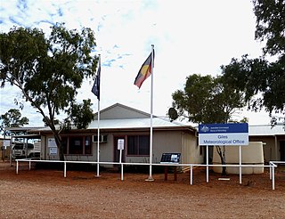
Giles Weather Station is located in Western Australia near the Northern Territory border, about 750 kilometres (470 mi) west-south-west of Alice Springs and 330 kilometres (210 mi) west of Uluru. It is the only staffed weather station within an area of about 2,500,000 square kilometres (970,000 sq mi) and is situated mid-continent and near the core of the subtropical jetstream. This means it plays an important role as a weather and climate observatory for the country, particularly eastern and southeastern Australia, and particularly for rainfall predictions. The station is on the Great Central Road and the nearest township is the Warakurna Aboriginal settlement, 5 kilometres (3 mi) North. Giles is within the Shire of Ngaanyatjarraku and is in the foothills of the Rawlinson Ranges.

Neale Junction is an isolated location in the Great Victoria Desert of Western Australia, where the Anne Beadell and Connie Sue Highways intersect. It is 172 km (107 mi) west of Ilkurlka. Neale Junction was named after Commander Frank Neale, who flew a Percival Gull through the area during the Mackay Aerial Reconnaissance Survey Expedition to Western and South Australia in 1935.

The Sandy Blight Junction Road is a remote outback track in Australia joining the Great Central Road, Western Australia and Gary Junction Road, Northern Territory. It was built under the direction of legendary surveyor Len Beadell as part of a network of roads for the Weapons Research Establishment at Woomera, South Australia. It is located approximately 500 km (310 mi) west of Alice Springs.

The Gunbarrel Road Construction Party (GRCP) was the name bestowed upon a team of road builders by Len Beadell in 1955, after which the well known outback track Gunbarrel Highway was named. Over a period of eight years, Beadell and the GRCP built more than 6,000 kilometres of dirt roads in remote areas of central Australia for the Weapons Research Establishment at Woomera, South Australia.

The Gary Junction Road is an outback unsealed road in Australia built by Len Beadell in the 1960s as part of a network of roads for the Weapons Research Establishment at Woomera, South Australia. In its original form, the Gary Junction Road ran from Liebig bore in the Northern Territory to Callawa Station in Western Australia. On present day maps, it is depicted as running from the Tanami Road to Gary Junction, just east of the Canning Stock Route, a distance of 852 kilometres. The road was named after Beadell's only son Gary.

The Talawana Track is a remote unsealed track that runs between Windy Corner on the Gary Highway and the Marble Bar Road in Western Australia, a distance of 596 kilometres. The majority of it was built by Len Beadell and the Gunbarrel Road Construction Party in 1963 as part of a series of connecting roads for the Woomera rocket range in South Australia. It was the final road they built.

Mount Davies Road is a remote unsealed outback track which runs from Mount Davies (Pipalyatjara) in the far north-west corner of South Australia to Anne's Corner on the Anne Beadell Highway 397 kilometres (247 mi) to the south-east. It was built during 1956 and 1957 by the Gunbarrel Road Construction Party (GRCP) surveyed and led by Len Beadell, for the Weapons Research Establishment at Woomera, South Australia.

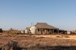
Carnegie Station, or Carnegie pastoral lease, is located north of Laverton and east of Wiluna in Western Australia and is the most eastern of pastoral leases found on the Gunbarrel Highway.

Jackie Junction is a remote location in Western Australia on the Gunbarrel Highway. It was named by the road builder Len Beadell after his youngest daughter and is at the junction of the original Gunbarrel Highway and the road to Warburton. It is 69 kilometres (43 mi) north of Warburton.

Mount Beadell is a mountain located in the Gibson Desert region of Western Australia. It is named after surveyor and explorer Len Beadell, builder of the Gunbarrel Highway. The location is very remote being 155 km (96 mi) west of Jackie Junction and 295 km (183 mi) east of Carnegie Station, the western terminus of the original Gunbarrel Highway.
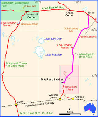
Maralinga to Emu Road is a remote unsealed outback track that links Maralinga to Emu in the western region of South Australia. It was built by Len Beadell for the Weapons Research Establishment of Salisbury, South Australia in 1955.

Vokes Hill Corner to Cook Road is a remote unsealed outback track that links Vokes Hill Corner on the Anne Beadell Highway to Cook on the Trans-Australian Railway in the far west of South Australia. It was built by Len Beadell for the Australian Government's Weapons Research Establishment in late 1961.