Francois Peron National Park is a national park on the Peron Peninsula in Western Australia, 726 km north of Perth, and located within the boundary of the Shark Bay World Heritage area. The nearest towns to the park are Denham, which is found on the southern edge of the park and Carnarvon which is found about 80 kilometres (50 mi) to the north.

Dirk Hartog Island is an island off the Gascoyne coast of Western Australia, within the Shark Bay World Heritage Area. It is about 80 kilometres long and between 3 and 15 kilometres wide and is Western Australia's largest and westernmost island. It covers an area of 620 square kilometres and is approximately 850 kilometres north of Perth.

Shark Bay is a World Heritage Site in the Gascoyne region of Western Australia. The 23,000-square-kilometre (8,900 sq mi) area is located approximately 800 kilometres (500 mi) north of Perth, on the westernmost point of the Australian continent. UNESCO's listing of Shark Bay as a World Heritage Site reads:

The Shark Bay Marine Park is a protected marine park located within the UNESCO World Heritage–listed Shark Bay, in the Gascoyne region of Western Australia. The 748,725-hectare (1,850,140-acre) marine park is situated over 800 kilometres (500 mi) north of Perth and 400 kilometres (250 mi) north of Geraldton.

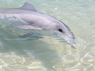
Denham is the administrative town for the Shire of Shark Bay, Western Australia. At the 2016 census, Denham had a population of 754. Located on the western coast of the Peron Peninsula 831 kilometres (516 mi) north of Perth, Denham is the westernmost publicly accessible town in Australia, and is named in honour of Captain Henry Mangles Denham of the Royal Navy, who charted Shark Bay in 1858. Today, Denham survives as the gateway for the tourists who come to see the dolphins at Monkey Mia, which is located 23 kilometres (14 mi) northeast of the town. The town also has an attractive beach and a jetty popular with those interested in fishing and boating.

The Carnarvon xeric shrublands is a deserts and xeric shrublands ecoregion of Western Australia. The ecoregion is coterminous with the Carnarvon Interim Biogeographic Regionalisation for Australia (IBRA) bioregion.

Monkey Mia is a popular tourist destination located about 900 kilometres (560 mi) north of Perth, Western Australia. The reserve is 25 kilometres (16 mi) northeast of the town of Denham in the Shark Bay Marine Park and World Heritage Site.

Hamelin Bay is a bay and a locality on the southwest coast of Western Australia between Cape Leeuwin and Cape Naturaliste. It is named after French explorer Jacques Félix Emmanuel Hamelin, who sailed through the area in about 1801. It is south of Cape Freycinet.

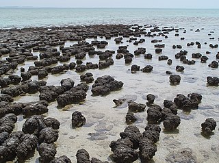
The Hamelin Pool Marine Nature Reserve is a protected marine nature reserve located in the UNESCO World Heritage–listed Shark Bay in the Gascoyne region of Western Australia. The 127,000-hectare (310,000-acre) nature reserve boasts the most diverse and abundant examples of living marine stromatolites in the world, monuments to life on Earth over 3,500 million years BP.

The Shire of Shark Bay is a local government area of Western Australia in the Gascoyne region. It has an area of 25,423 km2 and a population of about 950. It is made up of two peninsulas and Shark Bay, located at the westernmost point of Australia. There is one town in the Shire of Shark Bay, Denham, which is the administrative centre for the Shire. There are also a number of small communities; they are Useless Loop, Monkey Mia, Nanga and Hamelin Pool. The Overlander and The Billabong are roadhouses.
Monkey Mia Airport is an airport located on the Peron Peninsula within the Shark Bay World Heritage Site in the Gascoyne region serving Monkey Mia, a resort in Western Australia, and the nearby town of Denham.

Faure Island is a 58 km2 island pastoral lease and nature reserve, east of the Francois Peron National Park on the Peron Peninsula, in Shark Bay, Western Australia. It lies in line with the Monkey Mia resort to the west, and the Wooramel River on the eastern shore of Shark Bay. It is surrounded by the Shark Bay Marine Park and Shark Bay World Heritage Site and, as the Faure Island Sanctuary, is owned and managed by the Australian Wildlife Conservancy (AWC).

Useless Loop is a town located on the Heirisson Prong on Denham Sound in the Southern Region of UNESCO World Heritage Site Shark Bay, Western Australia. The town of Denham is on the opposite shore of the sound and the more famous Monkey Mia near Denham. Useless Loop is a closed company town, with 70 employees and their families servicing the Solar Salt Operation Shark Bay which was established in 1962 by Shark Bay Resources Ltd. A joint venture was formed in 1973 with Mitsui & Co. Ltd which acquired full ownership in 2005, incorporated as Shark Bay Salt Pty Ltd. In 2015, Useless Loop's salt exports were running at a rate of 1.4 million tonnes per annum.
L'Haridon Bight is one of the bays on the eastern side of the Peron Peninsula in the Shark Bay World Heritage Site in the Gascoyne region of Western Australia.
Henri Freycinet Harbour, also known as Freycinet Estuary, is one of the inner gulfs of Shark Bay, Western Australia, a World Heritage Site that lies to the west of the Peron Peninsula.
Tourist Drives in Western Australia are routes through areas of scenic or historic significance, designated by route markers with white numbers on a brown shield. Tourist Drives were introduced into Western Australia while Eric Charlton was the state government Minister for Transport in the 1990s. The 28 numbered routes collectively traverse more than 2,000 kilometres (1,200 mi) across the state. In addition to the Tourist Drives, there are unnumbered routes such as the Golden Pipeline Heritage Trail, and local governments may designate and maintain local scenic drives, generally unnamed and unnumbered.
Main Roads Western Australia controls the major roads in the state's Gascoyne region. North West Coastal Highway, a north-south route near the coastline, is the main highway the region. A series of main roads connect coastal towns to the highway, and local roads provide additional links and access to the inland portion of the region. Roads are often named after the towns or areas they connect.
The Malgana, also known as the Malkana, are an Aboriginal Australian people of Western Australia.

Hamelin Station or Hamelin Station Reserve is a tourist site and conservation reserve, that was a pastoral lease, occupying an area of 202,000 hectares near the Shark Bay World Heritage Area in Western Australia. It was formerly a sheep station running merino sheep. It is famous for its free flowing artesian bore from the Birdrong Formation in the Carnarvon Artesian Basin, near the homestead, which has created an artificial lake that has become a haven for bird life.
Ocean Park Aquarium is a privately owned open-to-public oceanarium located approximately 10 kilometres (6.2 mi) south of Denham in the Shark Bay area of Western Australia that is a major tourism drawcard in the area. Visitors can experience marine creatures on display such as coralfish, butterflyfish, clownfish, lionfish, stonefish, moray eel, stingrays, sea snakes, octopus and crustaceans in the indoor aquarium centre.


