
Francois Peron National Park is a national park on the Peron Peninsula in Western Australia, 726 km north of Perth, and located within the boundary of the Shark Bay World Heritage area. The nearest towns to the park are Denham, which is found on the southern edge of the park and Carnarvon which is found about 80 kilometres (50 mi) to the north.
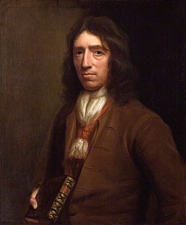
William Dampier was an English explorer, pirate, privateer, navigator, and naturalist who became the first Englishman to explore parts of what is today Australia, and the first person to circumnavigate the world three times. He has also been described as Australia's first natural historian, as well as one of the most important British explorers of the period between Francis Drake and James Cook, he "bridged those two eras" with a mix of piratical derring-do of the former and scientific inquiry of the later. His expeditions were among the first to identify and name a number of plants, animals, foods, and cooking techniques for a European audience; being among the first English writers to use words such as avocado, barbecue, and chopsticks. In describing the preparation of avocados, he was the first European to describe the making of guacamole, named the breadfruit plant, and made frequent documentation of the taste of numerous foods foreign to the European palate such as flamingo and manatee.
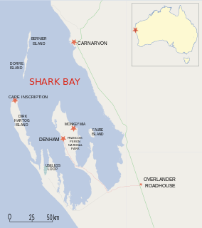
Dirk Hartog Island is an island off the Gascoyne coast of Western Australia, within the Shark Bay World Heritage Area. It is about 80 kilometres long and between 3 and 15 kilometres wide and is Western Australia's largest and most western island. It covers an area of 620 square kilometres and is approximately 850 kilometres north of Perth. It was named after Dirk Hartog, a Dutch sea captain, who first encountered the Western Australian coastline close to the 26th parallel south latitude, which runs through the island. After leaving the island, Hartog continued his voyage north-east along the mainland coast. Hartog gave the Australian mainland one of its earliest known names, as Eendrachtsland, which he named after his ship Eendracht, meaning "concord". The island is now the location of a major environmental reconstruction project, Return to 1616, that has seen all introduced livestock and feral animals removed, with eleven native species now in various stages of reintroduction.
Adélie Land is a claimed territory on the continent of Antarctica. It stretches from a portion of the Southern Ocean coastline all the way inland to the South Pole. France has administered it as one of five districts of the French Southern and Antarctic Lands since 1955 and applied the Antarctic Treaty System rules since 1961. Article 4 deals with territorial claims, and although it does not renounce or diminish any preexisting claims to sovereignty, it also does not prejudice the position of Contracting Parties in their recognition or non-recognition of territorial sovereignty. France has had a permanent station in Adélie Land since April 9, 1950. The current Dumont d'Urville Station has a winter population around 25, but this goes up to about 78 during the Antarctic summer. A species of penguin was named after it, called the Adelie Penguin.

Pacific coast may be used to reference any coastline that borders the Pacific Ocean.
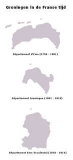
Ems-Occidental was a department of the First French Empire in the present-day Netherlands and Germany. It was formed in 1810, when the Kingdom of Holland was annexed by France. Its territory corresponded more or less with the present Dutch provinces of Groningen and Drenthe. Its capital was Groningen. The department was subdivided into the following arrondissements and cantons :
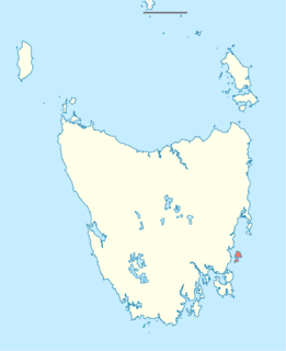
Maria Island is a mountainous island located in the Tasman Sea, off the east coast of Tasmania, Australia. The 115.5-square-kilometre (44.6 sq mi) island is contained within the Maria Island National Park, which includes a marine area of 18.78 square kilometres (7.25 sq mi) off the island's northwest coast. The island is about 20 kilometres (12 mi) in length from north to south and, at its widest, is about 13 kilometres (8.1 mi) west to east. At its closest point, Point Lesueur, the island lies approximately 4 kilometres (2.5 mi) off the east coast of Tasmania.
The Austin expedition of 1854 was an expedition of exploration undertaken in Western Australia by Robert Austin in 1854. Members of Austin's party comprised John Hardey, Kenneth Brown, J.T. Fraser (artist), Thomas Whitfield, James Guerin, Richard Buck, J. Edwards, W. Cant, Charles Farmer, and J. Woodward; and aboriginals Narryer, Wambinning, Wooddang and Souper.
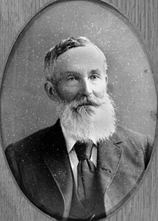
Francis Thomas "Frank" Gregory was an Australian explorer and politician.
The Greenough River is a river in the Mid West region of Western Australia.
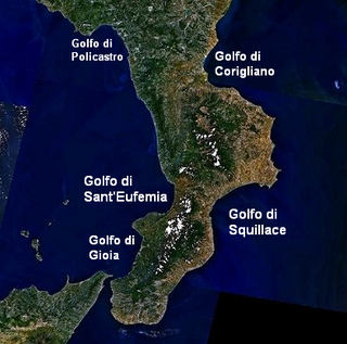
The Gulf of Squillace is a body of water, an inlet of the Ionian Sea along the Calabrian coast of Italy.

The Andean Region is one of the 10 administrative regions in which Venezuela was divided for its development plans in 1969.

Shell Beach is a beach in the Shark Bay region of Western Australia, located 45 km (28 mi) south-east of Denham.

Useless Loop is a town located on the Heirisson Prong on Denham Sound in the Southern Region of UNESCO World Heritage Site Shark Bay, Western Australia. The town of Denham is on the opposite shore of the sound and the more famous Monkey Mia near Denham. Useless Loop is a closed company town, with 70 employees and their families servicing the Solar Salt Operation Shark Bay which was established in 1962 by Shark Bay Resources Ltd. A joint venture was formed in 1973 with Mitsui & Co. Ltd which acquired full ownership in 2005, incorporated as Shark Bay Salt Pty Ltd. In 2015, Useless Loop's salt exports were running at a rate of 1.4 million tonnes per annum.
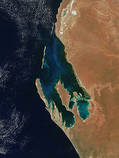
Peron Peninsula is a long narrow peninsula located in the Shark Bay World Heritage site in Western Australia, at about 25°51' S longitude and 113°30' E latitude. It is some 130 kilometres (81 mi) long, running north-northwesterly, located east of Henri Freycinet Harbour and west of Havre Hamelin and Faure Island. It is the largest of the Shark Bay peninsulas. Significant settlements include Denham and Monkey Mia. An airport is located there. It is the location of former Pastoral leases Peron and Nanga stations. It is the main location of land access to points within the World Heritage site. The northern area contains the Francois Peron National Park. It is surrounded by the Shark Bay Marine Park and its lower southeast part is adjacent to the Hamelin Pool Marine Nature Reserve.
L'Haridon Bight is one of the bays on the eastern side of the Peron Peninsula in the Shark Bay World Heritage Site in the Gascoyne region of Western Australia.

Paisley Islet is an islet located in the Great Australian Bight immediately off the west coast of Kangaroo Island in South Australia approximately 104 kilometres west south-west of Kingscote. It is currently part of the Flinders Chase National Park.

European land exploration of Australia deals with the opening up of the interior of Australia to European settlement which occurred gradually throughout the colonial period, 1788–1900. A number of these explorers are very well known, such as Burke and Wills who are well known for their failed attempt to cross the interior of Australia, as well as Hamilton Hume and Charles Sturt.

The European exploration of Australia first began in February 1606, when Dutch navigator Willem Janszoon landed in Cape York Peninsula and on October that year when Spanish explorer Luís Vaz de Torres sailed through, and navigated, Torres Strait islands. Twenty-nine other Dutch navigators explored the western and southern coasts in the 17th century, and dubbed the continent New Holland.
Nickol Bay is a bay between the Burrup Peninsula and Dixon Island, on the Pilbara coast in Western Australia.


