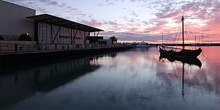
Geraldton is a coastal city in the Mid West region of the Australian state of Western Australia, 424 kilometres (263 mi) north of the state capital, Perth.

North Glengarry is a township in eastern Ontario, Canada, in the United Counties of Stormont, Dundas and Glengarry. It is a predominantly rural area located between Ottawa-Gatineau, Montreal and Cornwall.

Greenstone is an amalgamated town in the Canadian province of Ontario with a population of 4,636 according to the 2016 Canadian Census. It stretches along Highway 11 from Lake Nipigon to Longlac and covers 2,767.19 km2 (1,068.42 sq mi).

Edith Dircksey Cowan was an Australian social reformer who worked for the rights and welfare of women and children. She is best known as the first Australian woman to serve as a member of parliament. Cowan has been featured on the reverse of Australia's 50-dollar note since 1995.

South Glengarry is a township in eastern Ontario, Canada on the Saint Lawrence River in the United Counties of Stormont, Dundas and Glengarry. South Glengarry borders Quebec.

Meekatharra is a town in the Mid West region of Western Australia. Meekatharra is a Yamatji word meaning "place of little water". At the 2016 census, Meekatharra had a population of 708, with 34.0% being of Aboriginal descent.

The City of Geraldton-Greenough was a local government area in the Mid West region of Western Australia, 424 kilometres (263 mi) north of the state capital, Perth on the Indian Ocean. It covered an area of 1,798.3 square kilometres (694.3 sq mi), and its seat of government was the town of Geraldton.
Beresford is a northern coastal suburb of Geraldton, Western Australia. Its local government area is the City of Greater Geraldton.
Bluff Point is a northern coastal suburb of Geraldton, Western Australia. Its local government area is the City of Greater Geraldton.
Strathalbyn is a northeastern suburb of Geraldton, Western Australia. Its local government area is the City of Greater Geraldton.
Drummond Cove is a coastal town located 12 kilometres (7 mi) north of Geraldton, Western Australia in the local government area of the City of Greater Geraldton. The locality was gazetted in 1985.
Mahomets Flats is an inner southern coastal suburb of Geraldton, Western Australia in the local government area of the City of Greater Geraldton.
Mount Tarcoola is a southern suburb of Geraldton, Western Australia. Its local government area is the City of Greater Geraldton.
Sunset Beach is an outer northern coastal suburb of Geraldton, Western Australia. Its local government area is the City of Greater Geraldton.

Glengarry is a town in the Gippsland region of Victoria, Australia. The town is located in the City of Latrobe local government area, 165 kilometres (103 mi) south east of the state capital, Melbourne. At the 2016 census, Glengarry had a population of 1084.

The City of Greater Geraldton is a local government area in the Mid West region of Western Australia, 424 kilometres (263 mi) north of the state capital, Perth on the Indian Ocean. It covers an area of 12,625.5 square kilometres (4,874.7 sq mi), and its seat of government is the town of Geraldton.
Main Roads Western Australia controls the major roads in the state's Mid West region. There are four main highways through the Mid West: The north-south coastal route of Brand Highway and North West Coastal Highway, the inland alternative Great Northern Highway, and the northern section of Goldfields Highway, which links Meekatharra with Kalgoorlie. A network of main roads connects towns within the Mid West to each other, the highways, and neighbouring regions, with local roads providing additional links and access to smaller townsites. Roads are often named after the towns they connect.
Geraldton was an electoral district of the Legislative Council of Western Australia from 1870 to 1890, during the period when the Legislative Council was the sole chamber of the Parliament of Western Australia.
Boynedale is a rural locality in the Gladstone Region, Queensland, Australia. In the 2016 census, Boynedale had a population of 17 people.
Glengarry is a suburb in the New Zealand city of Invercargill.
