
Bowes is a town in the Mid West region of Western Australia. [2]
Bowes is a town in the Mid West region of Western Australia. [2]
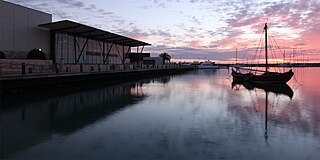
Geraldton is a coastal city in the Mid West region of the Australian state of Western Australia, 424 kilometres (263 mi) north of the state capital, Perth.

Northampton is a town 52 kilometres (32 mi) north of Geraldton, in the Mid West region of Western Australia. At the 2011 census, the town had a population of 868.The town contains a National Trust building. The town lies on the North West Coastal Highway. Originally called The Mines, Northampton was gazetted in 1864 and named after the colony's Governor, John Hampton. The town was sited in the Nokanena Brook valley, between the hamlets around the two major copper mines in the area, the Wanerenooka and the Gwalla.

The Shire of Northampton is a local government area in the Mid West region of Western Australia, about 50 kilometres (30 mi) north of Geraldton and about 460 kilometres (290 mi) north of the state capital, Perth. The Shire covers an area of 13,738 square kilometres (5,304 sq mi), and its seat of government is the town of Northampton, with the largest settlement being Kalbarri.
Beresford is a northern coastal suburb of Geraldton, Western Australia. Its local government area is the City of Greater Geraldton.
Rudds Gully is a locality 9 kilometres (5.6 mi) south-southeast of Geraldton, Western Australia. Its local government area is the City of Greater Geraldton.
Drummond Cove is a coastal town located 12 kilometres (7 mi) north of Geraldton, Western Australia in the local government area of the City of Greater Geraldton. The locality was gazetted in 1985.
Glenfield is a locality north of Geraldton, Western Australia. Its local government area is the City of Greater Geraldton.
Meru is a locality southeast of Geraldton, Western Australia. Its local government area is the City of Greater Geraldton.
West End is a western suburb of Geraldton, Western Australia. Its local government area is the City of Greater Geraldton.
Deepdale is a locality east of Geraldton, Western Australia. Its local government area is the City of Greater Geraldton.
Moresby is a locality northeast of Geraldton, Western Australia, on the north bank of the Chapman River. Its local government area is the City of Greater Geraldton.
Woorree is an eastern suburb of Geraldton, Western Australia. Its local government area is the City of Greater Geraldton.
Spalding is a northeastern suburb of Geraldton, Western Australia. Its local government area is the City of Greater Geraldton.
Sunset Beach is an outer northern coastal suburb of Geraldton, Western Australia. Its local government area is the City of Greater Geraldton.
Utakarra is an eastern suburb of Geraldton, Western Australia. Its local government area is the City of Greater Geraldton. Prior to 1 July 2007, it was the seat of government of the Shire of Greenough.
Tenindewa is a small town located between Geraldton and Mullewa along the Geraldton – Mount Magnet Road in the Mid West region of Western Australia. At the 2006 census, the Tenindewa district had a population of 143.

The City of Greater Geraldton is a local government area in the Mid West region of Western Australia, 424 kilometres (263 mi) north of the state capital, Perth on the Indian Ocean. It covers an area of 12,625.5 square kilometres (4,874.7 sq mi), and its seat of government is the town of Geraldton.
Geraldton is the central suburb of the City of Greater Geraldton in the Mid West region of Western Australia.
Moonyoonooka is a rural locality on the eastern margin of Geraldton, in the Mid West region of Western Australia. It contains Geraldton Airport. At the 2016 census, Moonyoonooka had a population of 245. Of employed people, 22.4% worked in the vegetable horticulture industry. Notably 9.1% of residents speak Vietnamese at home, eight times the national average.
Ogilvie is a small town in the Mid West region of Western Australia. Other than sheep, agriculturally the area was known for wheat, barley, oats, lupins, Wimmera rye, and clover.
| | This article about a location in Western Australia is a stub. You can help Wikipedia by expanding it. |