
Dalwallinu, colloquially called Dally, is a town in the Wheatbelt region of Western Australia, located 248 km from Perth via the Great Northern Highway. Agriculture and supporting industries are the town's primary economic activities. The town is the first town on the Wildflower Way, a tourist route that stretches north to Mullewa. The town has an elevation of 335 metres (1,099 ft). At the 2016 census, Dalwallinu had a population of 699.
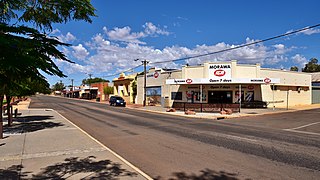
Morawa is a town in the Mid West region of Western Australia. It is located within the Shire of Morawa, approximately 370 kilometres (230 mi) north of the state capital Perth, on the railway line between Wongan Hills and Mullewa.

Yalgoo is a town in the Mid West region, 499 kilometres (310 mi) north-north-east of Perth, Western Australia and 118 kilometres (73 mi) east-north-east of Mullewa. Yalgoo is in the local government area of the Shire of Yalgoo.
Parkeston is a suburb of the city of Kalgoorlie, Western Australia, located 3 kilometres (1.9 mi) east of the city centre. At the 2016 census, it had a population of 60, down from 69 in 2006. It contains the Ninga Mia Aboriginal community.
Amery is a rail siding and townsite 9 kilometres (5.6 mi) northeast of Dowerin in the Wheatbelt region of Western Australia.

Perenjori is a townsite in the northern agricultural region, 348 kilometres (216 mi) north of Perth and 39 kilometres (24 mi) south-east of Morawa. It is located on the Wongan Hills to Mullewa railway line which was opened in 1915. Perenjori was approved as the name of a siding in April 1913, and later that year the government decided to establish a townsite there. Perenjori townsite was gazetted in 1916.

Wyalkatchem is a town in the central Wheatbelt region, 192 kilometres (119 mi) east-north-east of Perth, 35 kilometres (22 mi) east of Dowerin and 44 kilometres (27 mi) south of Koorda. At the 2021 census, Wyalkatchem had a population of 358.

Three Springs is a town located 313 kilometres (194 mi) north of Perth, Western Australia on the Midlands Road, which until the opening of the Brand Highway in 1975 was the main road route from Perth to the state's north. The town is the seat of the Shire of Three Springs. Its economy is based on agriculture and mining.
Yilliminning is a small town located in the southern Wheatbelt region of Western Australia, 212 kilometres (132 mi) southeast of the state capital, Perth and 23 kilometres (14 mi) east of Narrogin. At the 2006 census, Yilliminning had a population of 337.
Kweda is a small town located in the Wheatbelt region of Western Australia, about 45 kilometres (28 mi) east of the town of Brookton.

Trayning is a town in the north-eastern Wheatbelt region of Western Australia, 236 kilometres (147 mi) east of the state capital, Perth, on the Nungarin–Wyalkatchem Road. At the 2006 census, Trayning had a population of 122.
Yuna is a small town in the Mid West region of Western Australia, in the Shire of Chapman Valley, 62 kilometres (39 mi) northeast of the city of Geraldton.
Peak Hill is the name of a goldfield, locality and the site of a gold mining ghost town in the Murchison Region of Western Australia. The gold mine covers 2,162 hectares and consists of four open-cut mines, titled: Main, Jubilee, Fiveways and Harmony.

Yelbeni is a small town 222 km east-northeast of Perth, Western Australia along the Nungarin-Wyalkatchem Road situated in the Wheatbelt region of Western Australia. At the 2006 census, Yelbeni had a population of 118.
Nanson is a small town in the Mid West region of Western Australia, between the city of Geraldton and the town of Northampton. The town is situated on the banks of the Chapman River in the Chapman Valley. At the 2006 census, Nanson had a population of 386.
Tenindewa is a small town located between Geraldton and Mullewa along the Geraldton – Mount Magnet Road in the Mid West region of Western Australia. At the 2006 census, the Tenindewa district had a population of 143.
Yoweragabbie is a small town in the Mid West region of Western Australia between the towns of Mount Magnet and Yalgoo.

Pintharuka is an abandoned townsite in the Mid West region of Western Australia. The town is located between the towns of Morawa and Mullewa on the Mullewa-Wubin Road
The Northampton railway line ran from Geraldton through Northampton and on to Ajana in Western Australia. It operated between 1879 and 1957. It was the first government railway constructed in Western Australia.
Ogilvie is a small town in the Mid West region of Western Australia. Other than sheep, agriculturally the area was known for wheat, barley, oats, lupins, Wimmera rye, and clover.

