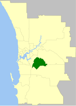
The City of Gosnells is a local government area in the southeastern suburbs of the Western Australian capital city of Perth, located northwest of Armadale and about 20 kilometres (12 mi) southeast of Perth's central business district. The City covers an area of 128 square kilometres (49.42 sq mi), a portion of which is state forest rising into the Darling Scarp to the east, and had a population of approximately 118,000 at the 2016 Census. The largest activity centre in the City is the Central Maddington shopping centre. District centres exist in the Gosnells town centre and Thornlie.

Cranbrook is a small town in the Shire of Cranbrook in the Great Southern region of Western Australia between Katanning, Kojonup and Mount Barker, situated 320 km south of Perth. It is billed as "The Gateway to the Stirlings", referring to the nearby Stirling Range National Park. At the 2006 census, Cranbrook had a population of 280.

Welshpool is an inner southeastern suburb of Perth, Western Australia, located mostly within the City of Canning and partially within the Town of Victoria Park.

Kelmscott is a southeastern suburb of Perth, Western Australian within the local government area of the City of Armadale. It is 23 kilometres (14 mi) southeast of Perth along the Albany Highway.

Cannington is a southern suburb of Perth, Western Australia. Its local government area is the City of Canning.

Woodbridge is a suburb of Perth, Western Australia, located within the City of Swan local government area. Formerly part of Midland and previously informally named West Midland, its name, which was officially gazetted on 1 March 2001, is from Governor James Stirling's original 1829 land grant which he named after his wife's family property near Guildford in England.
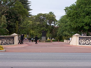
Karrakatta is a suburb of Perth, Western Australia, located within the City of Nedlands and 7 km west of the central business district. Its postcode is 6010.

Calen is a rural town and coastal locality in the Mackay Region, Queensland, Australia. In the 2021 census, the locality of Calen had a population of 427 people.
Crossman is a locality in the Shire of Boddington in the Peel Region of Western Australia, 125 kilometres (78 mi) south-southeast of the state capital, Perth, along Albany Highway, and 12 kilometres (7.5 mi) east of Boddington.

Gosnells is a suburb located within the City of Gosnells. Gosnells is approximately 20 kilometres (12 mi) south-east of the Perth central business district. It contains the Gosnells town centre which includes the Council offices, library and the Gosnells Railway Station.
Bilbarin is a small town in the Shire of Corrigin in the Wheatbelt region of Western Australia.
Wandilo is a north-western suburb of Mount Gambier in the Australian state of South Australia. It was named after the railway station on the Mount Gambier railway line, and is recorded to mean "a swamp where native companions resort".
Calvert is a rural town and locality in the City of Ipswich, Queensland, Australia. In the 2021 census, the locality of Calvert had a population of 374 people.
South Talwood was a rural locality in the Goondiwindi Region, Queensland, Australia. It was on the border of Queensland and New South Wales. It was 107 kilometres (66 mi) west of Goondiwindi. In the 2021 census, South Talwood had a population of 101 people.
Gurulmundi is a rural locality in the Western Downs Region, Queensland, Australia. In the 2021 census, Gurulmundi had a population of 19 people.

Wyberba is a rural locality in the Southern Downs Region, Queensland, Australia. In the 2021 census, Wyberba had a population of 63 people.

Dalwogon is a rural locality in the Western Downs Region, Queensland, Australia. In the 2021 census, Dalwogon had a population of 53 people.
Kronkup is a locality in the Great Southern Region of Western Australia.
Hay is a locality located in the Great Southern region of Western Australia.
The Upper Chapman Valley railway line was a 61 kilometres (38 mi) long state-owned and WAGR-operated railway line in the Mid West region of Western Australia, connecting Wokarina, a siding on the Northampton railway line at Glenfield, to Yuna.

