
Westonia is a small town located in the eastern Wheatbelt region of Western Australia, 10 kilometres (6 mi) north of the Great Eastern Highway. It is the main town in the Shire of Westonia.

Cue is a small town in the Mid West region of Western Australia, located 620 km north-east of Perth. At the 2016 census, Cue had a population of 178. Cue is administered through the Cue Shire Council, which has its chambers in the historic Gentlemans Club building. The current president is Ross Pigdon. The Cue Parliament is held twice yearly in May and November.

Tintinara is a town located in the Murray and Mallee region of the South East of South Australia.

Palmer is a town just east of the Adelaide Hills region of South Australia along the Adelaide-Mannum Road, 70 kilometres east-north-east of the state capital, Adelaide and 15 km west-north-west of Mannum. It is located in the Mid Murray Council local government area. At the 2006 census, Palmer had a population of 329.

The Shire of Cue is a local government area in the Mid West region of Western Australia, about 420 kilometres (260 mi) east-northeast of the port city of Geraldton and about 650 kilometres (400 mi) north-northeast of the state capital, Perth. The Shire covers an area of 13,623 square kilometres (5,260 sq mi), and its seat of government is the town of Cue.

Day Dawn is a ghost town in the Mid West/upper Murchison region of Western Australia. It was a significant mining town and mine in the late nineteenth century. Located a short distance south-west of Cue, rich gold deposits were discovered there in 1891 by Ned Heffernan, who pegged out what became known as the 'Day Dawn Reef'.

Sandstone is a small town in the Mid West region of Western Australia 157 kilometres (98 mi) east of Mount Magnet and 661 kilometres (411 mi) north of the state capital, Perth. At the 2016 census, Sandstone and the surrounding Shire of Sandstone a population of 89 people, including 19 families. Sandstone is the administrative centre and only town in the Shire of Sandstone local government area.
Peak Hill is the name of a goldfield, locality and the site of a gold mining ghost town in the Murchison Region of Western Australia. The gold mine covers 2,162 hectares and consists of four open-cut mines, titled Main, Jubilee, Fiveways and Harmony.

Pindar is a small town in the Mid West Region of Western Australia. It is located about 30 km east of Mullewa in the local government area of the City of Greater Geraldton.

Austin is an abandoned town in the Murchison region of Western Australia. The town is located south of Cue on an island in Lake Austin and for this reason was also known as Lake Austin and The Island Lake Austin.

Clonbinane is a sparse pastoral community in the Australian state of Victoria. It is located 55 kilometres (34 mi) north of the state capital city, Melbourne. Geographically, it lies east of the Hume Freeway but now lacks a distinctive township precinct. According to Crown Land records of 1856, the pastoral region was part of the Western Port District. At the 2021 census, Clonbinane had a population of 347.

Pithara is a small town in the wheatbelt region of Western Australia. It is located about 240 km north of Perth, in the Shire of Dalwallinu. At the 2011 census, Pithara had a population of 257, a 25% fall from the previous 2006 census.

Widgiemooltha is an abandoned town in Western Australia 631 kilometres (392 mi) east of Perth between Kambalda and Norseman in the Goldfields-Esperance region of Western Australia. It is found on the southern shoreline of Lake Lefroy.
Youndegin is a small town 155 kilometres (96 mi) east of Perth, Western Australia along the Goldfields Road in the Wheatbelt region of Western Australia.
Kurnalpi is an abandoned town in the Goldfields-Esperance region of Western Australia. It lies in what was once Maduwongga territory and is situated between Norseman and Laverton.
Sir Samuel is an abandoned town located between Leinster and Wiluna in the Goldfields-Esperance region of Western Australia.
Tuckanarra is a small town in the Shire of Cue in the Murchison region of Western Australia. The town is located between Cue and Meekatharra along the Great Northern Highway in the Mid West region of Western Australia.
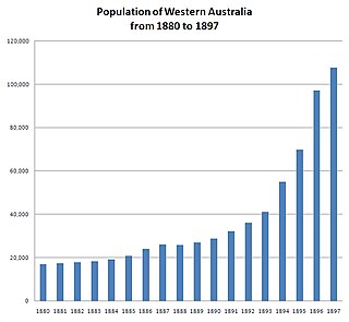
In the latter part of the nineteenth century, discoveries of gold at a number of locations in Western Australia caused large influxes of prospectors from overseas and interstate, and classic gold rushes. Significant finds included:
Cuddingwarra is an abandoned town in the Mid West region of Western Australia. The town is located between Cue and Big Bell.
Yerilla is an abandoned town located in the Goldfields-Esperance region in Western Australia. It is found between Kalgoorlie and Laverton.

