
The Emu War, also known as the Great Emu War, was a nuisance wildlife management military operation undertaken in Australia over the later part of 1932 to address public concern over the number of emus said to be running amok in the Campion district of Western Australia. The unsuccessful attempts to curb the population of emus, a large flightless bird indigenous to Australia, employed soldiers armed with Lewis guns—leading the media to adopt the name "Emu War" when referring to the incident. While a number of the birds were killed, the emu population persisted and continued to cause crop destruction.

Perenjori is a townsite in the northern agricultural region, 348 kilometres (216 mi) north of Perth and 39 kilometres (24 mi) south-east of Morawa. It is located on the Wongan Hills to Mullewa railway line which was opened in 1915. Perenjori was approved as the name of a siding in April 1913, and later that year the government decided to establish a townsite there. Perenjori townsite was gazetted in 1916.

Moora is a townsite located 177 km north of Perth in the Wheatbelt region of Western Australia. Moora was one of the original stations on the Midland railway line to Walkaway, and the townsite was gazetted in 1895. At the 2016 census, Moora had a population of 1,773.

The town of Hyden is located 292 kilometres (181 mi) east-southeast of Perth, Western Australia in the Shire of Kondinin. Hyden is home to Wave Rock, Mulka's Cave and Hippos Yawn, all popular local tourist attractions.

Gnowangerup is a town located 61 kilometres (38 mi) south-east of Katanning in the Great Southern region of Western Australia.

The Shire of Beverley is a local government area in the Wheatbelt region of Western Australia about 130 kilometres (80 mi) southeast of Perth, the state capital. The Shire covers an area of 2,372 square kilometres (916 sq mi), starting 20 kilometres (12 mi) outside Armadale in the Darling Scarp and extending eastwards beyond the scarp into agricultural lands which support broad acre activities such as livestock and cropping. Its seat of government is the town of Beverley, which accommodates just over half of the Shire's population.
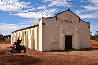
Gutha is a townsite in the Mid West region of Western Australia, 32 kilometres (20 mi) north of Morawa.
Somerton is a village between Tamworth and Gunnedah on the Oxley Highway in northern New South Wales Australia. In the 2016 census, there were 277 people in Somerton. Somerton Village adjoins the plentiful Peel River.

Henry Gregory was an Australian politician. He was a Ministerialist member of the Western Australian Legislative Assembly from 1897 to 1911, representing the electorates of North Coolgardie (1897-1901) and Menzies (1901-1911). He was state Minister for Mines from 1901 to 1904 under George Leake and Walter James and Minister for Mines and Railways from 1905 to 1911 under Hector Rason, Newton Moore and Frank Wilson. He rose to become Treasurer from 1910 to 1911, a role that also entailed him acting as Premier if Wilson was absent, but lost his seat at the 1911 state election.
Corindi Beach, pronounced Cor-in-"dye" although Cor-in-"dee" is widely used recently, historically also known as Pipeclay Beach until a name change in 1954, Corinda until a forced change to be provided postal service to avoid confusion or by Red Bank as Corindi River was formerly known, is a beach and small seaside farming town located on the Mid North Coast of New South Wales, Australia. The village is situated 33 kilometres (21 mi) north of Coffs Harbour and 50 kilometres (31 mi) south of Grafton. The original village of Corindi is slightly north along the Pacific Highway at Post Office Lane and Casson Close. Corindi means "grey" in local indigenous language referring to the pipeclay on the beach.

Joshua Thomas Hoskins Whitsitt was an Australian politician. He was a member of the Tasmanian House of Assembly from 1909 to 1922 and a member of the Australian House of Representatives from 1922 to 1925.
Walgoolan is a small town located in the eastern Wheatbelt region of Western Australia. It is situated between Merredin and Bodallin along the Great Eastern Highway.

The Geraldton Guardian was established at Geraldton, Western Australia on 1 October 1906 to serve the Victoria and Murchison Districts. It was launched on principles of liberal democracy, state rights, nationalism and British preference.
The Northampton railway line ran from Geraldton through Northampton and on to Ajana in Western Australia. It operated between 1879 and 1957. It was the first government railway constructed in Western Australia.
This is a list of newspaper titles published in, or for the Mid West region of Western Australia.
For a more comprehensive treatment with full quotes of newspaper articles refer Wikibooks chapter on VIN Geraldton
Harold Arthur Charles Daffen was an Australian politician. He was a Liberal Party of Australia member of the Western Australian Legislative Council from 1947 to 1950, representing Central Province.
The Geraldton Road District was an early form of local government area in the Mid West region of Western Australia. It was based in the town of Geraldton, although Geraldton was not part of the road district, having been separately incorporated as the Municipality of Geraldton.
Friederich Wilhelm Gustav Liebe was a building contractor and farmer in Western Australia.
Gordon Tidy was a journalist in Australia before returning to England as a minister of religion, among other occupations. His friendships included with poets Will H. Ogilvie (1869–1963), A. B. 'Banjo' Paterson (1864–1941), Arthur Bayldon (1865–1958), and Henry Lawson (1867–1922), and war historian Charles E. W. Bean (1879–1968).
