
Buntine is a small town located in the Wheatbelt region of Western Australia, about 300 kilometres (186 mi) north of Perth, the state capital, along the Great Northern Highway within the Shire of Dalwallinu.

Meekatharra is a town in the Mid West region of Western Australia. Meekatharra is a Yamatji word meaning "place of little water". At the 2016 census, Meekatharra had a population of 708, with 34.0% being of Aboriginal descent.

Dalwallinu, colloquially called Dally, is a town in the Wheatbelt region of Western Australia, located 248 km from Perth via the Great Northern Highway. Agriculture and supporting industries are the town's primary economic activities. The town is the first town on the Wildflower Way, a tourist route that stretches north to Mullewa. The town has an elevation of 335 metres (1,099 ft). At the 2016 census, Dalwallinu had a population of 699.
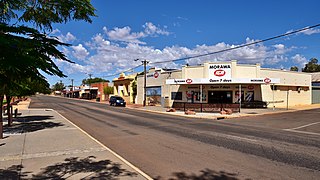
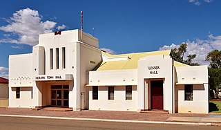
Morawa is a town in the Mid West region of Western Australia. It is located within the Shire of Morawa, approximately 370 kilometres (230 mi) north of the state capital Perth, on the railway line between Wongan Hills and Mullewa.

Mullewa is a town in the Mid West region of Western Australia, 450 kilometres (280 mi) north of Perth and 98 kilometres (61 mi) east-northeast of Geraldton. Mullewa is well known for an abundance of wildflowers in spring and it is one of the few places in Western Australia that the wreath flower grows. The surrounding areas produce wheat and other cereal crops. The town is a receival site for Cooperative Bulk Handling.

Perenjori is a townsite in the northern agricultural region, 348 kilometres (216 mi) north of Perth and 39 kilometres (24 mi) south-east of Morawa. It is located on the Wongan Hills to Mullewa railway line which was opened in 1915. Perenjori was approved as the name of a siding in April 1913, and later that year the government decided to establish a townsite there. Perenjori townsite was gazetted in 1916.

Trayning is a town in the north-eastern Wheatbelt region of Western Australia, 236 kilometres (147 mi) east of the state capital, Perth, on the Nungarin–Wyalkatchem Road. At the 2006 census, Trayning had a population of 122.

The Shire of Mingenew is a local government area in the Mid West region of Western Australia, about 110 kilometres (68 mi) southeast of the city of Geraldton and about 370 kilometres (230 mi) north of the state capital, Perth. The Shire covers an area of 1,939 square kilometres (749 sq mi), and its seat of government is the town of Mingenew.
The Shire of Morawa is a local government area in the Mid West region of Western Australia, about 170 kilometres (106 mi) east-southeast of the city of Geraldton and about 390 kilometres (242 mi) north of the state capital, Perth. The Shire covers an area of 3,516 square kilometres (1,358 sq mi), and its seat of government is the town of Morawa.

The Shire of Perenjori is a local government area in the Mid West region of Western Australia, about 360 kilometres (224 mi) north of the state capital, Perth. The Shire covers an area of 8,313 square kilometres (3,210 sq mi), and its seat of government is the town of Perenjori.
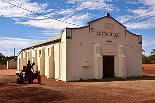
Gutha is a townsite in the Mid West region of Western Australia, 32 kilometres (20 mi) north of Morawa.

Maya is a small town in the Mid West region of Western Australia.

Pithara is a small town in the wheatbelt region of Western Australia. It is located about 240 km north of Perth, in the Shire of Dalwallinu. At the 2011 census, Pithara had a population of 257, a 25% fall from the previous 2006 census.
Bowgada is a small town in Western Australia located on the Mullewa Wubin Road 366 kilometres (227 mi) north of Perth in the Mid West region.
Bunjil is a small town in Western Australia located on the Mullewa Wubin Road 326 kilometres (203 mi) north of Perth in the Mid West region. At the 2021 census, it had a population of 61.

Yelbeni is a small town 222 km east-northeast of Perth, Western Australia along the Nungarin-Wyalkatchem Road situated in the Wheatbelt region of Western Australia. At the 2006 census, Yelbeni had a population of 118.
Tenindewa is a small town located between Geraldton and Mullewa along the Geraldton – Mount Magnet Road in the Mid West region of Western Australia. At the 2006 census, the Tenindewa district had a population of 143.

Korrelocking is a small town situated between Wyalkatchem and Trayning in the Wheatbelt region of Western Australia. At the 2006 census, Korrelocking had a population of 76.

Pintharuka is an abandoned townsite in the Mid West region of Western Australia. The town is located between the towns of Morawa and Mullewa on the Mullewa-Wubin Road
Canna is a small town in the Mid West region of Western Australia. It is located between the towns of Morawa and Mullewa on the Mullewa-Wubin Road. At the 2006 census, Canna had a population of 81.

