
The City of Nedlands is a local government area in the inner western suburbs of the Western Australian capital city of Perth, about 7 kilometres (4 mi) west of Perth's central business district. The city is situated within the western suburbs of the metropolitan area—known colloquially as the “golden triangle” for the concentration of wealth and high housing values.

Erica is a town in Victoria, Australia, on Rawson Road, in the Shire of Baw Baw.
Yilliminning is a small town located in the southern Wheatbelt region of Western Australia, 212 kilometres (132 mi) southeast of the state capital, Perth and 23 kilometres (14 mi) east of Narrogin. At the 2006 census, Yilliminning had a population of 337.

The Shire of Mount Marshall is a local government area in the Wheatbelt region of Western Australia, about 80 kilometres (50 mi) north-northwest of Merredin and about 300 kilometres (186 mi) northeast of the state capital, Perth. The Shire covers an area of 10,190 square kilometres (3,934 sq mi), and its seat of government is the town of Bencubbin.
Roelands is a town in the South West region of Western Australia on the South Western Highway, between Brunswick Junction and Bunbury. At the 2011 census, Roelands had a population of 620.
Highbury, originally Wolwolling, is a small town in the Wheatbelt region of Western Australia, located along the Great Southern Highway between Narrogin and Wagin. At the 2006 census, Highbury had a population of 493.

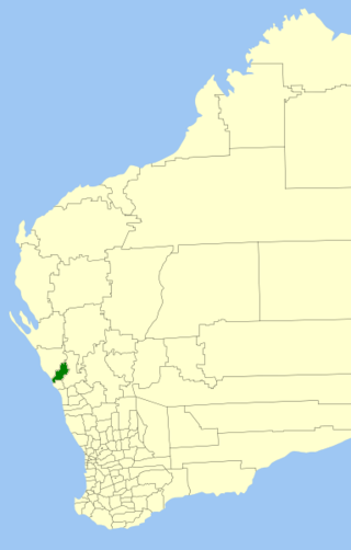
The Shire of Boddington is a local government area in the Peel region of Western Australia, about 120 kilometres (75 mi) south-east of the state capital, Perth. The Shire covers an area of 1,901 square kilometres (734 sq mi), and its seat of government is the town of Boddington.

Trayning is a town in the north-eastern Wheatbelt region of Western Australia, 236 kilometres (147 mi) east of the state capital, Perth, on the Nungarin–Wyalkatchem Road. At the 2006 census, Trayning had a population of 122.

Koorda is a town in the north eastern Wheatbelt region of Western Australia, approximately 236 kilometres (147 mi) east of Perth and 43 kilometres (27 mi) north of Wyalkatchem at the northeastern end of the Cowcowing Lakes. It is the main town in the Shire of Koorda. At the 2016 census Koorda had a population of 414. The surrounding areas produce wheat and other cereal crops. The town is a receival site for Cooperative Bulk Handling.
The Shire of Chapman Valley is a local government area located in the Mid West region of Western Australia, immediately northeast of the City of Geraldton and about 440 kilometres (273 mi) north of Perth, the state capital. The Shire covers an area of 3,965 square kilometres (1,531 sq mi) and its seat of government is the small town of Nabawa.
Nabawa is a small town in the Mid West region of Western Australia, and is located in the Shire of Chapman Valley 42 kilometres (26 mi) northeast of the city of Geraldton.
Yuna is a small town in the Mid West region of Western Australia, in the Shire of Chapman Valley, 62 kilometres (39 mi) northeast of the city of Geraldton.

Pithara is a small town in the Wheatbelt region of Western Australia. It is located about 240 km north of Perth, in the Shire of Dalwallinu. At the 2011 census, Pithara had a population of 257, a 25% fall from the previous 2006 census.

Kununoppin is a small town in the Wheatbelt region of Western Australia. The town is located on the Nungarin–Wyalkatchem Road and in the Shire of Trayning local government area, 257 kilometres (160 mi) north east of the state capital, Perth, Western Australia. At the 2006 census, Kununoppin had a population of 151.

Yelbeni is a small town 222 km east-northeast of Perth, Western Australia along the Nungarin-Wyalkatchem Road situated in the Wheatbelt region of Western Australia. At the 2006 census, Yelbeni had a population of 118.
Welbungin is a small town located just off the Koorda–Southern Cross road 287 km (178 mi) from Perth in the Wheatbelt region of Western Australia.
Howatharra is a small town in the Mid West region of Western Australia, between Geraldton and Binnu. It is situated just off the North West Coastal Highway and on the Oakagee River.

Korrelocking is a small town situated between Wyalkatchem and Trayning in the Wheatbelt region of Western Australia. At the 2006 census, Korrelocking had a population of 76.

The City of Greater Geraldton is a local government area in the Mid West region of Western Australia, 424 kilometres (263 mi) north of the state capital, Perth on the Indian Ocean. It covers an area of 12,625.5 square kilometres (4,874.7 sq mi), and its seat of government is the town of Geraldton.
Naraling is a locality in the Mid West region of Western Australia.

