
Rothsay is a city in Otter Tail and Wilkin counties in the State of Minnesota. The population was 498 at the 2020 census. One of Rothsay's major tourist attractions is the large prairie chicken statue near the northwest outskirts of the town.
Rothesay is the principal town on the Isle of Bute, Scotland.

Cue is a small town in the Mid West region of Western Australia, located 620 km north-east of Perth. At the 2016 census, Cue had a population of 178. Cue is administered through the Cue Shire Council, which has its chambers in the historic Gentlemans Club building. The current president is Ross Pigdon. The Cue Parliament is held twice yearly in May and November.

Ravensthorpe is a town 541 km south-east of Perth and 40 km inland from the south coast of Western Australia. It is the seat of government of the Shire of Ravensthorpe. At the 2021 census, Ravensthorpe had a population of 2,085.

Menzies is a town in the Goldfields-Esperance region of Western Australia, 728 kilometres (452 mi) east-northeast of the state capital, Perth, and 133 kilometres (83 mi) north-northwest of the city of Kalgoorlie. At the 2016 census, Menzies had a population of 108. Aboriginal people have lived in this area since time immemorial, and the local group are the Kaburn Bardu.
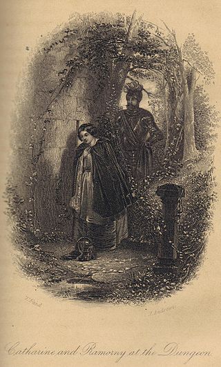
The Fair Maid of Perth is an 1828 novel by Sir Walter Scott, one of the Waverley novels. Inspired by the strange, but historically true, story of the Battle of the North Inch, it is set in Perth and other parts of Scotland around 1400.

Sandstone is a small town in the Mid West region of Western Australia 157 kilometres (98 mi) east of Mount Magnet and 661 kilometres (411 mi) north of the state capital, Perth. At the 2016 census, Sandstone and the surrounding Shire of Sandstone had a population of 89 people, including 19 families. Sandstone is the administrative centre and only town in the Shire of Sandstone local government area.
Broad Arrow is a ghost town in Western Australia, located 38 km north of Kalgoorlie and 633 km east of Perth. It is on the Kalgoorlie to Leonora Road.

Gold mining in Western Australia is the third largest commodity sector in Western Australia (WA), behind iron ore and LNG, with a value of A$17 billion in 2021–22. The 6.9 million troy ounces sold during this time period was the highest amount in 20 years and accounted for almost 70 percent of all gold sold in Australia.
Gabanintha is a ghost town located in the Mid West region of Western Australia approximately 40 km south east of Meekatharra on the Meekatharra-Sandstone road. The town is situated within the Murchison goldfields.
Bulong is an abandoned town in Western Australia located 580 kilometres (360 mi) east of Perth in the Goldfields-Esperance region of Western Australia.

Widgiemooltha is an abandoned town in Western Australia 631 kilometres (392 mi) east of Perth, Western Australia between Kambalda and Norseman in the Goldfields-Esperance region of Western Australia. It is found on the southern shoreline of Lake Lefroy.
Varley is a small town located between Hyden and Lake King in the Wheatbelt region of Western Australia.
Black Flag is an abandoned town in Western Australia, 30 km north west of Kalgoorlie. It is on the Black Flag to Ora Banda Road in the Goldfields-Esperance region of Western Australia.
Bardoc is an abandoned town in the Goldfields-Esperance region of Western Australia. It is situated between Kalgoorlie and Menzies along the Goldfields Highway.
Dunnsville is an abandoned town in Western Australia located 46 km north-west of Coolgardie in the Goldfields-Esperance region of Western Australia.
Feysville is an abandoned town in the Goldfields-Esperance region of Western Australia. It is situated between Kalgoorlie and Kambalda just off the Goldfields Highway.
Mertondale is an abandoned town located between Leonora and Laverton in the Goldfields-Esperance region of Western Australia.
Horseshoe is an abandoned town in Western Australia located in the Murchison goldfields within the Mid West region of Western Australia situated between Meekatharra and Newman. The town is adjacent to the Peak Hill goldfields.
Cuddingwarra is an abandoned town in the Mid West region of Western Australia. The town is located between Cue and Big Bell.

