Garratt Road Bridge

Last updated

Garratt Road Bridge
Garratt Road upstream Bridge from NW.jpg
View along upstream bridge from north-west
Coordinates 31°55′57″S115°54′59″E / 31.932439°S 115.916439°E / -31.932439; 115.916439 Coordinates: 31°55′57″S115°54′59″E / 31.932439°S 115.916439°E / -31.932439; 115.916439
Crosses Swan River
Locale BayswaterAscot
Owner Main Roads Western Australia
Structure number
  • 950 (upstream)
  • 952 (downstream)
Characteristics
MaterialTimber
Total length237 m (778 ft)
Width8.7 m (29 ft)
Longest span12.1 m (40 ft)
No. of spans38
Piers in water37
History
DesignerErnest Godfrey
Constructed byMain Roads Department
Statistics
TypeState Registered Place
Designated23 March 2010
Reference no. 11342
Location
Garratt Road Bridge

Garratt Road Bridge consists of two adjacent bridges over the Swan River, linking the suburbs of Bayswater and Ascot in Perth, Western Australia. The upstream bridge was built in 1935, while the matching downstream bridge was built in 1972. [1] The site was significant prior to the construction of Garratt Road Bridge – it featured in Aboriginal mythology, and was in the near vicinity of 1880s bridges for pedestrians and trains. From that time there were various proposal to provide a vehicular crossing between Bayswater and Bassendean. Interest peaked in 1928, but plans were delayed due to the Great Depression. The first bridge, designed by Main Roads Chief Engineer Ernest Godfrey, was constructed in 1934–35. It allowed two lanes of traffic to cross the Swan River, alongside pedestrians on an adjacent footbridge.

Contents

Increasing traffic volume led to the bridge being widened by one and a half metres (5 ft) in 1962. By the end of that decade, a second bridge was being planned to cope with rising levels of congestion. It was constructed during 1971–72, but with only a 40-year design life as it was expected to be redundant once the planned Beechboro–Gosnells Highway (modern-day Tonkin Highway) opened. From the 1970s, Main Roads has maintained the bridges with procedures that vastly extended the bridges' lifespans, including concrete overlays on the decks, and retrofitting of steel girders. The heritage value of the structure was recognised in 1998, and Garratt Road Bridge was included in the City of Bayswater's Municipal Heritage Inventory. Eleven years later, in 2009, it was added to the state heritage list, and a permanent entry was given on 23 March 2010.

Description

Garratt Road Bridge consists of a pair of bridges across the Swan River, between Bayswater and Ascot. The upstream bridge, from 1935, carries southbound traffic, pedestrians, and two pipes, while northbound traffic travels on the 1970 downstream bridge. Both bridges are predominantly constructed from timber, and feature "timber piles driven into the river bed linked with timber cross bracing and double beams top and bottom and then spanned by timber logs which in turn support the wooden decking". The original bridge is at a lower height, and some of its beams have been replaced by Rolled Steel Joists. While both bridges have modern steel safety rails, the original white-painted wooden rail is still present along the pedestrian path. The original bridge has approximately 38 spans over 37 piers, along a 238-metre (781 ft) length. [2]

Main Roads Western Australia maintains and controls Garratt Road Bridge. The road is designated Highway H37, while the bridges are designated Structure Number 950 (upstream) and Structure Number 952 (downstream). The original bridge has 38 spans over a length of 236.4 metres (776 ft), a width of 8.75 metres (28.7 ft), and a deck area of 2,068.50 square metres (22,265.1 sq ft). The road width is 8.35 metres (27.4 ft), while the footpath width is 1.3 metres (4 ft 3 in). The newer bridge has similar measurements: 38 spans over a length of 237.7 metres (780 ft), width of 8.65 metres (28.4 ft), deck area of 2,056.11 square metres (22,131.8 sq ft), and road width of 8.21 metres (26.9 ft). The longest spans of each bridges are 12.1 metres (40 ft) in length. [3]

Garratt Road Bridge is the longest timber bridge still in existence in Western Australia. It may have been the longest ever built in the state, [lower-alpha 1] [4] and the downstream bridge was probably the last wooden bridge to be built in Perth. [lower-alpha 2] [5]

Garratt Road Bridge (banner).jpg
View of the upstream Garratt Road Bridge in 2009

History

Background

Before European colonisation, the area around the Garratt Road Bridge site was inhabited by the Mooro people to the north of the Swan River, and the Beeloo people to the south. Beeloo territory included the Martagarup [lower-alpha 3] flats, immediately south-west of the bridge site, one of their fishing grounds. The area also features in Aboriginal mythology. It is believed that the Swan River was created by the meanderings of the Wagyl, a snakelike being from Dreamtime, and that scales shed from the male Wagyl remain visible in the riverbank at Ascot. [1] :4

Following the establishment of the Swan River Colony in 1829, European settlers James Birkett and James Henty received 1,000 acres (400 ha) blocks containing the modern-day bridge site. Birkett's land was north of the river, and following his death it was sold to James Drummond in 1839. Henty's land was south of the river, and changed hands multiple times in a short timespan – Henty preferred the north side of the river, and so sold his block to Philip Dod, who disliked the marsh-like quality of the land, and traded it to John Wall Hardey, founder of the Wesley Church in Perth. Hardey expanded his land, which he named Grove Farm, by buying neighbouring riverside lots. [1] :5

Hardey was influential in the development of the Belmont area, as he took on the roles of Justice of the Peace, magistrate and member of the Legislative Council. Harvey lobbied for river crossings to be constructed in 1837; The Causeway was built in 1843, and a crossing over the Helena River soon followed. Horse racing began on Grove Farm in 1848, and roads were constructed using convict labour to improve access from the road to Guildford (modern-day Great Eastern Highway). In 1850 the races moved to the current site of Ascot Racecourse. With the advent of horse training facilities in 1856, a horse pulley system was set up to provide a river crossing – close to the modern-day Garratt Bridge site, but east of the racecourse. Bridges were constructed in the 1880s to improve access to the races – a mechanical drawbridge for pedestrians opened in 1881, and a railway bridge was built in 1885. [1] :5–6 The bridge, later known as the Belmont railway bridge, [lower-alpha 4] [6] [7] carried a spur of the Perth–Guildford line that terminated south of the racecourse, but only operated on racing days. [1] :5–6

Proposals

There has been proposals for a vehicle bridge since the late 1880s; it was one of the most advocated issues in the Bayswater area. [2] The first formal request to the Perth Road Board for a vehicular crossing between Bayswater and Belmont was made in 1904, but it was declined due to insufficient trade potential. The Belmont and Bayswater Road Boards [lower-alpha 5] requested the state government construct a bridge, as new industries were developing in the districts. The government, however, considered there were more urgent matters than the bridge, which was estimated to cost £6000. [1] :6

In 1922 the idea of a bridge was suggested again, this time as part of a circular tram line. Belmont Park and Bayswater Road Boards made a deputation to the state government on 23 February 1923, but again received an unenthusiastic response on 13 April, stating that the £9100 was not available and could not be justified. Following a public meeting in 1924, residents of Bayswater and Belmont made a direct appeal to the premier, asserting that a new bridge would reduce traffic over The Causeway, and save the cost of replacing the structure, said to be £200,000. A government survey was conducted, and three estimates were obtained – which put the cost at £35,000 to £38,000 – but no funding was provided. [1] :6–7

Renewed interest in the proposed bridge came from the newly formed Town Planning Commission in 1928. [2] Three potential sites were considered: [1] :7 The Town Planning Commission advocated for a bridge to the east of Ascot Racecourse, connecting to Slade Street north of the river. [2] The Bayswater Road Board also preferred an eastern option, connecting to Epsom Avenue south of the river, while the Belmont Park Road Board recommended the crossing be further west, at Abernethy Road. The third option was at Garratt Road, midway between the eastern and western options, and was the government's final decision. Plans did not progress due to the onset of the Great Depression. [1] :7

Construction

Planning for a bridge recommenced in 1933, with construction beginning the following year. Main Roads Chief Engineer Ernest Godfrey designed the bridge. Godfrey was the first bridge engineer for Main Roads, and oversaw the design of all of Main Roads' bridges statewide between 1928 and 1957. The bridge was designed and constructed economically, out of low cost local wood – Wandoo, Jarrah and Karri – and without treatments such as beam shaping that would have added unnecessary cost. Fill material came from levelling Ascot Racecourse, which had contained a World War I era mound in its centre. The mound had initially been used by soldiers during training, and later by children playing. Sustenance labourers worked on the construction project, [1] :7–8 which required homes and businesses to be demolished or repositioned. [2] Garratt Road Bridge opened on 1 January 1935, the same day as the Perth Cup, having cost £35,000 for the bridge itself, and an additional £9000 for the approaches. Like the road it connects to, the bridge is named after Mary Anne Traylen (née Garratt). Her husband, William Traylen, named various roads in Bayswater after family members when he subdivided his land, c.1890. [1] :7–8

In 1956, fire wrecked the nearby Belmont railway bridge, which was then demolished. Buses became the main form of transportation across the river to Ascot Racecourse, [1] :9 but by that time Garratt Road Bridge was already congested due to increasing traffic. [2] The bridge was widened in 1962 to cater for the increased volume in both ways, from 8.38 metres (27.5 ft) to 10 metres (33 ft). The works also allowed a 107-centimetre (42 in) diameter water main to be carried, on the bridges's western side. [1] :9

The 1960s saw increasing traffic volume across Garratt Road Bridge. By the end of that decade, planning was under way for another bridge at the site to cater for the increasing demand. The new bridge was planned as a short-term solution, with only a forty-year design life, as it was expected to be unnecessary once the planned Beechboro–Gosnells Highway (modern-day Tonkin Highway) opened. The design of the second bridge mimicked the original bridge, especially in aesthetics and the span configuration. It was constructed downstream from the original, to carry northbound traffic. Works began in 1971, and the bridge opened on 4 July 1972. [1] :10 A new road, Resolution Drive, was constructed in 1972 to tie into the new bridge. It carried northbound traffic as part of a one-way pairing with Grandstand Road, which then only carried the southbound traffic. [1] :10–11 By 2007 the one-way pair was removed, traffic was diverted wholly to the now dual carriageway Grandstand Road, and Resolution Drive was reverted to a residential street.

Maintenance and upgrades

From the 1970s, Main Roads applied newly developed maintenance procedures that vastly extended the bridges' lifespans. Such methods included "concrete decks; concrete pile and abutment overlays; removal of decayed timber and replacement with structural epoxy filler; sealing endgrain decking and tops of wingwall piles; diffusible fungicides; clearance of undergrowth to decrease surrounding humidity; skilled inspections, and treatment of metal components". [1] :11 Concrete decks were added to the upstream and downstream bridges in 1972 and 1980 respectively, to minimise rot, control termites, and distribute loads on the bridge more evenly. Steel girders were also retrofitted, replacing wooden half-caps. Karri used for half-caps was particularly prone to termite attack; while the outside had been treated with sodium fluoride and arsenic trioxide, the inside was susceptible to being hollowed out, and was the cause of a partial collapse of the upstream bridge in 1987. [1] :11

Steel barricades were added to the upstream bridge in 2000, to prevent swimmers jumping from the bridge into the paths of ferries. In 2005 wooden half-caps supporting the water pipeline were removed, and replaced with steel. The following year, new approach slabs were installed, and new expansion joints were added to the existing concrete, to reduce the increased stress that increased traffic volumes were causing. [1] :12 Bridge works were undertaken again from 12 December 2014, with an expected completion date of 1 April 2015. [10] The downstream road, then the upstream road were resurfaced in 2017, which included the installation of new steel safety barriers, and the reinforcement or replacement of the wooden pylons supporting the bridges with concrete pilings. [11] [12]

Heritage listing

The City of Bayswater included Garratt Road Bridge on its Municipal Heritage Inventory on 24 February 1998, and it received classification from the National Trust on 14 April 1998. [2] In 1998, Main Roads Western Australia undertook a survey of the state's bridges, and confirmed the heritage value of the upstream Garratt Road Bridge. [1] :11 It was added to the state heritage list in Autumn 2009, [13] and on 23 March 2010 received a permanent entry in the Register of Heritage Places. [14]

See also

Notes

  1. According to its permanent entry on the State Register of Heritage Places
  2. According to a Channel 7 documentary
  3. meaning leg deep
  4. the third railway crossing of the Swan River to be constructed, after the earlier Fremantle and Guildford bridges
  5. Bayswater rather than Perth, as the boundary between the road boards was changed to Caledonian Avenue in 1906; [8] the formation of the Bayswater Road Board in 1897 had not changed the boundary of the Perth Road Board [9]

Related Research Articles

Swan River (Western Australia) River in Western Australia

The Swan River is a river in the south west of Western Australia. The river runs through the metropolitan area of Perth, Western Australia's capital and largest city.

City of Belmont Local government area in Western Australia

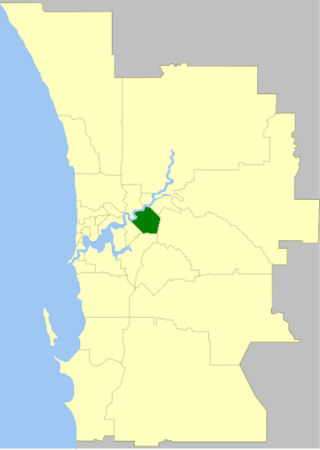
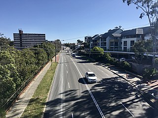
The City of Belmont is a local government area in the inner eastern suburbs of the Western Australian capital city of Perth, located about 8 kilometres (5 mi) east of Perth's central business district on the south bank of the Swan River. The City covers an area of 39.8 square kilometres (15.4 sq mi), maintains 225 km of roads and had a population of almost 40,000 as at the 2016 Census. The City of Belmont is a member of the Eastern Metropolitan Regional Council

Barwon River (Victoria) Perennial river in Victoria, Australia

The Barwon River is a perennial river of the Corangamite catchment, located in The Otways and the Bellarine Peninsula regions of the Australian state of Victoria.

Great Eastern Highway Highway in Western Australia

Great Eastern Highway is a 590-kilometre-long (370 mi) road that links the Western Australian capital of Perth with the city of Kalgoorlie. A key route for road vehicles accessing the eastern Wheatbelt and the Goldfields, it is the western portion of the main road link between Perth and the eastern states of Australia. The highway forms the majority of National Highway 94, although the alignment through the Perth suburbs of Guildford and Midland, and the eastern section between Coolgardie and Kalgoorlie are not included. Various segments form parts of other road routes, including National Route 1, Alternative National Route 94, and State Route 51.

Ascot Racecourse (Western Australia)

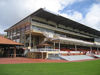
Ascot Racecourse is the major racecourse in Perth, Western Australia, situated approximately 8 kilometres east of the Perth central business district, with the headquarters of the Perth Racing positioned directly opposite.

The Causeway Road in Perth, Western Australia

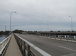
The Causeway is an arterial traffic crossing in Perth, Western Australia, linking the inner-city suburbs of East Perth and Victoria Park. It is carried over the Swan River at the eastern end of Perth Water by two bridges on either side of Heirisson Island. The current Causeway is the third structure to have been built across the river at this point.

Tonkin Highway Highway in Perth, Western Australia

Tonkin Highway is an 81-kilometre-long (50 mi) north–south highway and partial freeway in Perth, Western Australia, linking Perth Airport and Kewdale with the city's north-eastern and south-eastern suburbs. As of April 2020, the northern terminus is at the interchange with Brand Highway and Great Northern Highway in Muchea, and the southern terminus is at Thomas Road in Oakford. It forms the entire length of State Route 4, and connects to several major roads. Besides Brand Highway and Great Northern Highway, it also connects to Reid Highway, Great Eastern Highway, Leach Highway, Roe Highway, and Albany Highway.

Canning Bridge

Canning Bridge is a traffic bridge which is the most downstream crossing of the Canning River in the city of Perth, Western Australia. The bridge is a part of Canning Highway, and it connects the suburbs of Como and Applecross. The Canning River is approximately 100 metres (328 ft) wide at the crossing, the narrowest point of the river along its downstream stretch. It is located near the Canning Bridge railway station.
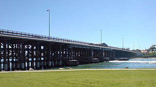
Bayswater, Western Australia Suburb of Perth, Western Australia

Bayswater is a suburb 6 km (4 mi) north-east of the central business district (CBD) of Perth, the capital of Western Australia. It is just north of the Swan River, within the City of Bayswater local government area. It is predominantly a low-density residential suburb consisting of single-family detached homes. However, there are several clusters of commercial buildings, most notably in the suburb's town centre, around the intersection of Whatley Crescent and King William Street and a light industrial area in the suburb's east.

Queen Victoria Street, Fremantle Road in Fremantle, Western Australia

Queen Victoria Street is the main road entering the city centre of Fremantle, Western Australia from the direction of Perth. The road was originally named Cantonment Road, but was subsequently renamed Victoria Road, and a few years later Queen Victoria Street, after Queen Victoria of the United Kingdom, to avoid confusion with similarly named roads in the area.

Redcliffe Bridge, Perth Bridge in Perth, Western Australia

Redcliffe Bridge is a traffic bridge which carries Tonkin Highway across the Swan River between the Perth suburbs of Ascot and Bayswater. It is named after Redcliffe, which is a nearby suburb.

Dickabram Bridge

Dickabram Bridge is a heritage-listed road-and-rail bridge over the Mary River between Miva and Theebine, both in the Gympie Region, Queensland, Australia. It was the major bridge on the Kingaroy railway line. It was designed by Henry Charles Stanley and built from 1885 to 1886 by Owen McDermott & Co. It is also known as Mary River Bridge (Miva). The bridge was registered on the former Register of the National Estate in 1988. It was added to the Queensland Heritage Register on 21 October 1992.

Clackline Bridge Road bridge in Clackline, Western Australia

Clackline Bridge is a road bridge in Clackline, Western Australia, 77 kilometres (48 mi) east of Perth in the Shire of Northam, that carried the Great Eastern Highway until 2008. It is the only bridge in Western Australia to have spanned both a waterway and railway, the Clackline Brook and the former Eastern Railway alignment. The mainly timber bridge has a unique curved and sloped design, due to the difficult topography and the route of the former railway. The bridge was designed in 1934 to replace two dangerous rail crossings and a rudimentary water crossing. Construction began in January 1935, and was completed relatively quickly, with the opening ceremony held in August 1935. The bridge has undergone various improvement and maintenance works since then, including widening by three metres (10 ft) in 1959–60, but remained a safety hazard, with increasing severity and numbers of accidents through the 1970s and 1980s. Planning for a highway bypass of Clackline and the Clackline Bridge began in the 1990s, and it was constructed between January 2007 and February 2008. The local community had been concerned that the historic bridge would be lost, but it remains in use as part of the local road network, and has been listed on both the Northam Municipal Heritage Inventory and the Heritage Council of Western Australia's Register of Heritage Places.

Guildford Road

Guildford Road is a major road in Perth, Western Australia, linking the inner-city suburb of Mount Lawley with Guildford in the north-east. The ten-kilometre-long (6.2 mi) road runs mostly parallel to the Swan River, on its northern side, and is part of State Route 51, which runs between Perth's CBD and Midvale. Guildford Road is maintained and controlled by Main Roads Western Australia, which uses the internal designation "H026 Guildford Road" for Guildford Road, as well as Bridge Street and James Street in Guildford. In the 1930s, the name Great Eastern Highway was coined to describe the road, but was actually used for the road on the other side of the Swan River.

The Belmont Railway Line was a branch railway in Western Australia that extended from the Eastern Railway at Bayswater to Belmont near the Ascot Racecourse. The line closed in 1956.

Kuljak Island, also known as Black Swan Island, is an artificial island in the Swan River. Situated between Ron Courtney Island upstream and Heirisson Island downstream, Kuljak Island is east of Maylands Peninsula and south of Garratt Road Bridge. Kuljak Island is surrounded by a number of smaller, also artificial, islets, and is entirely within the boundaries of the suburb of Ascot.

Murray River road bridge, Swan Hill

The Murray River road bridge is a heritage-listed road bridge that carries Swan Hill Road across the Murray River, on the border between New South Wales and Victoria, Australia. The bridge connects Murray Downs in New South Wales with McCallum Street in Swan Hill, Victoria. The bridge was built in 1896 and is owned by Transport for NSW. The bridge is also called the Swan Hill Bridge and the Swan Hill-Murray River Road Bridge. It was added to the New South Wales State Heritage Register on 20 June 2000.

Tooleybuc Bridge Bridge crossing Murray River in Victoria, Australia

The Tooleybuc Bridge is a dual heritage-listed road bridge that carries Tooleybuc Road across the Murray River, located in Tooleybuc, New South Wales, Australia. It was built in 1925. The bridge is owned by the Murray River Council, and is also called the Tooleybuc Bridge over Murray River. The bridge was added to the New South Wales State Heritage Register on 20 June 2000 and the Victorian Heritage Register on 10 July 2008.

Bayswater Subway

The Bayswater Subway is a road under rail subway near Bayswater railway station in Perth, Western Australia with a low clearance of 3.8 metres (12 ft). It has become well known in Perth and has received significant media coverage for being frequently struck by tall vehicles.

References

  1. 1 2 3 4 5 6 7 8 9 10 11 12 13 14 15 16 17 18 19 Heritage Council of Western Australia (March 2010). "Register of Heritage Places – Assessment Documentation: Garratt Road Bridge". Government of Western Australia. Archived from the original (PDF) on 26 December 2014. Retrieved 26 December 2014.Additional archives: 26 December 2014 .
  2. 1 2 3 4 5 6 7 City of Bayswater. "Garratt Road Bridge". inHerit. Government of Western Australia. Archived from the original on 26 December 2014. Retrieved 26 December 2014.Additional archives: 21 December 2014 .
  3. Main Roads Western Australia. "Road Information Mapping System". Government of Western Australia. Structures 950, 952. Archived from the original on 28 September 2013. Retrieved 21 December 2014.
  4. Heritage Council of Western Australia (March 2010). "Register of Heritage Places – Permanent Entry: Garratt Road Bridge". Government of Western Australia. p. 2. Archived from the original (PDF) on 26 December 2014. Retrieved 26 December 2014.Additional archives: 26 December 2014 .
  5. Seven Network (Australia). Perth (1971). Garratt Road Bridge under construction. Channel 7. Retrieved 26 December 2014.
  6. "Incendiarism Suspected". The Daily News . Perth, WA. 7 February 1907. p. 7. Retrieved 22 December 2014 via Tove (National Library of Australia).
  7. "Belmont Railway Bridge". The Daily News (Home Final ed.). Perth, WA. 29 May 1930. p. 9. Retrieved 22 December 2014 via Trove (National Library of Australia).
  8. "News and Notes". The West Australian . Perth, WA. 13 November 1906. p. 4. Retrieved 22 December 2014 via Trove (National Library of Australia).
  9. "Deputation from Bayswater". The Inquirer and Commercial News . Perth, WA. 5 February 1897. p. 6. Retrieved 22 December 2014 via Trove (National Library of Australia).
  10. "Bridge Works on 150 Garratt Road". Get The Bigger Picture. Government of Western Australia. Archived from the original on 24 December 2014. Retrieved 24 December 2014.Additional archives: 24 December 2014 .
  11. "Garratt Road Bridges Pile Potting & Maintanance". 13 August 2018. Archived from the original on 13 August 2018.
  12. "Timber Fencing Perth: Bayswater Garratt Road Bridge Installation 2017". 13 August 2018. Archived from the original on 13 August 2018.
  13. Fitzhardinge, Chris (July 2009). Davies, Tim (ed.). "Four wheel drives, formations, formwork, presidents and presentations" (PDF). News from Engineering WA: Engineers Australia WA Division Newsletter. Engineers Australia Western Australia Division: 3. Archived (PDF) from the original on 26 December 2014.
  14. "Heritage" (PDF). Western Australia Government Gazette. 23 March 2010. p. 2010:1085. Archived (PDF) from the original on 26 December 2014.Additional archives: 26 December 2014 .