
Bull Creek is a suburb of Perth, Western Australia, located within the local government area of City of Melville. The suburb lies to the south of a creek of the same name, which flows into the Canning River.

Thornlie railway station is a temporarily closed railway station on the Transperth network. It was the terminus of the Thornlie line, a spur of the Armadale Line, seventeen kilometres (11 mi) from Perth Station serving the suburb of Thornlie, Western Australia. Under construction is the Thornlie-Cockburn Link which will link to Cockburn Central railway station along the Mandurah line via two new stations, Nicholson Road railway station and Ranford Road railway station.

Kwinana bus station is a Transperth bus station located next to the Kwinana Marketplace Shopping Centre in Kwinana Town Centre. It has 10 stands and is served by five Transperth routes operated by Transdev WA.

Baldivis is a semi-rural residential suburb 46 kilometres (29 mi) south of Perth, Western Australia, and 11 kilometres (6.8 mi) southeast of the regional centre of Rockingham. It is located within the City of Rockingham local government area.
Bateman is a suburb of Perth, Western Australia, located within the City of Melville.

Canning Vale is a southern suburb of Perth, 22 km (13.7 mi) from the central business district. Its local government areas are the City of Canning and the City of Gosnells.

Bertram is a suburb of Perth, Western Australia, located within the City of Kwinana. Bertram derives its name from the family name of a Group Settler of the 1920s who owned land in the area. It was established as a locality name on 17 December 1998.

Leda is a southern suburb of Perth, Western Australia within the City of Kwinana. Leda is one of the five main suburbs of Kwinana.

Orelia is a southern suburb of Perth, Western Australia, located within the City of Kwinana.

Atwell is a suburb within the metropolitan area of Perth, Western Australia, situated 21 kilometres (13 mi) south of Perth City, and located in the City of Cockburn local government area.
Success is a southern suburb of Perth, the capital city of Western Australia, located within the City of Cockburn.

Canning Bridge railway station is a suburban railway and bus station on the Mandurah line in Perth, Western Australia. Situated in the suburb of Como next to the Canning River, the station is located at the interchange between the Kwinana Freeway and Canning Highway. The train platforms are at ground level within the median strip of the freeway, while the bus stands are on the bridge carrying Canning Highway.

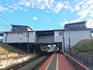
Bull Creek railway station is a railway station on the Transperth network. It is located on the Mandurah line, 11.7 kilometres from Perth station inside the median strip of the Kwinana Freeway serving the suburb of Bull Creek.

Murdoch railway station is a railway and bus station on the Transperth network. It is located on the Mandurah line, 13.8 kilometres (8.6 mi) from Perth station inside the median strip of the Kwinana Freeway serving the suburb of Murdoch.

Cockburn Central station is a bus and railway station on the Transperth network. It is located at the juncture of the Mandurah and – once completed – Thornlie lines, 20.5 kilometres (12.7 mi) from Perth station inside the median strip of the Kwinana Freeway serving the suburb of Cockburn Central.

Kwinana railway station is a railway station in Bertram and Parmelia, suburbs of Perth, Western Australia. It is on the Mandurah railway line, which is part of the Transperth commuter rail network, and it serves the City of Kwinana. It has two side platforms located in a cutting, accessed by a ground-level station concourse. Services run every 10 minutes during peak, and every 15 minutes between peak. The journey to Perth railway station is 32.9 kilometres (20.4 mi), and takes 26 minutes. The station has a bus interchange with five bus stands, and five regular bus routes.
Wellard railway station is a railway station in Wellard, a suburb of Perth, Western Australia. It is on the Mandurah railway line, which is part of the Transperth commuter rail network, and is located at the centre of a transit oriented development. It has two side platforms located in a cutting, accessed by a ground-level station concourse. Services run every 10 minutes during peak, and every 15 minutes between peak. The journey to Perth railway station is 37.1 kilometres (23.1 mi), and takes 30 minutes. The station has a bus interchange with four bus stands, and three regular bus routes.

Rockingham railway station is a railway station in Rockingham, a suburb of Perth, Western Australia. It is on the Mandurah railway line, which is part of the Transperth commuter rail network. It has two side platforms, linked by a pedestrian overpass accessed by stairs, a lift, and escalators. Services run every 10 minutes during peak, and every 15 minutes between peak. The journey to Perth railway station is 43.2 kilometres (26.8 mi), and takes 34 minutes. The journey to Mandurah railway station is 27.6 kilometres (17.1 mi), and takes 17 minutes. The station has a bus interchange with twelve bus stands, and 14 regular bus routes.

Perth is a suburb in the Perth metropolitan region, Western Australia that includes both the central business district of the city, and a suburban area spreading north to the northern side of Hyde Park. It does not include the separate suburbs of Northbridge or Highgate. Perth is split between the City of Perth and the City of Vincent local authorities, and was named after the city of the same name in Scotland.

Treeby is a southern suburb of Perth, Western Australia, located within the City of Cockburn. It is located on the east side of the Kwinana Freeway, close to Cockburn Central.

