History
Kwinana was first created for the 2008 state election. It was a new urban seat created as a result of the one vote one value reforms. For the most part it combined the southern portion of the district of Cockburn with the northern part of the district of Peel; it also took in territory previously covered by the districts of Rockingham and Serpentine-Jarrahdale.
At its creation, Kwinana was calculated to have a Labor Party majority of 69.2% to 30.8% versus the Liberal Party, [1] making it a very safe Labor seat. However, Labor candidate Roger Cook won the seat only narrowly against independent challenger Carol Adams, prevailing 50.79% to 49.21%. [2] Adams, the mayor of Kwinana, launched her independent candidacy after unsuccessfully contesting Labor preselection for the seat. [3] Adams sought a rematch in 2013, but Cook won with a slightly increased majority.
However, Kwinana was a very safe Labor seat in "traditional" two-party matchups between Labor and the Liberals; Cook would have easily won it with well over 60 percent of the two-party vote in 2008 and 2013. Proving this, Cook was easily reelected in 2017 with 68 percent of the two-party vote.
Geography
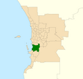
Kwinana, since the 2023 redistribution, includes the local government area of the City of Kwinana west of the Kwinana Freeway as well as parts of the adjoining City of Rockingham. The district takes in the suburbs of Naval Base, Hope Valley, Mandogalup, Kwinana Beach, Postans, The Spectacles, Medina, Orelia, Calista, Kwinana Town Centre, Parmelia, Bertram, Leda, as well as parts of Wellard, northern Baldivis and East Rockingham.
Previous versions of Kwinana also took in southern parts of the City of Cockburn (including Henderson, Wattleup, Hammond Park, Aubin Grove and Banjup), and parts of the City of Kwinana east of the namesake freeway (Wandi, Anketell and Casuarina). However, strong population growth in the area necestitated the creation of Baldivis in 2015, followed by Oakford in 2023 which both led to these suburbs being transferred away and caused Kwinana to both shrink and move progressively further south.
This page is based on this
Wikipedia article Text is available under the
CC BY-SA 4.0 license; additional terms may apply.
Images, videos and audio are available under their respective licenses.