
The City of Nedlands is a local government area in the inner western suburbs of the Western Australian capital city of Perth, about 7 kilometres (4 mi) west of Perth's central business district. The city is situated within the western suburbs of the metropolitan area—known colloquially as the “golden triangle” for the concentration of wealth and high housing values.
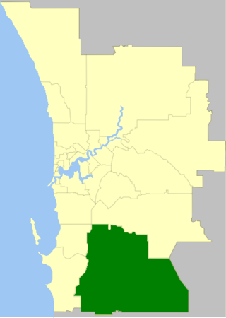
The Shire of Serpentine-Jarrahdale is a local government area in the outer southeastern metropolitan area of Perth, the capital of Western Australia, and has an area of 905 square kilometres (349 sq mi) and a population of 32,173 as at the 2021 census. Despite being named after two towns in the area, neither Serpentine nor Jarrahdale function as either the Shire's largest settlement (Byford) or the seat of government (Mundijong).

The Town of Victoria Park is a local government area of Western Australia. It covers an area of 17.62 km² in metropolitan Perth, the capital of Western Australia. It had a population of approximately 35,000 as at the 2016 census.

The City of Wanneroo is a local government area with city status in the northern suburbs of Perth, Western Australia. It is centred approximately 25 kilometres (15.5 mi) north of Perth's central business district and forms part of the northern boundary of the Perth metropolitan area. Wanneroo encompasses the federal divisions of Cowan, Moore and Pearce.

The Shire of Augusta Margaret River is a local government area in the south-west corner of the South West region of Western Australia, approximately 270 kilometres (168 mi) south of Perth. The shire covers an area of 2,243 square kilometres (866 sq mi) and had a population of over 14,000 at the 2016 Census, about half of whom live in the towns of Margaret River and Augusta.

Serpentine is a town located 55 kilometres (34 mi) south-southeast of Perth, the capital of Western Australia, and 7 km south of Mundijong.

Anketell is a suburb of Perth, Western Australia, located within the City of Kwinana.

Mandogalup is a suburb of Perth, Western Australia, located within the City of Kwinana. Its postcode is 6167.

Munster is a suburb of Perth, Western Australia, located within the City of Cockburn.

The City of Perth is a local government area and body, within the Perth metropolitan area, which is the capital of Western Australia. The local government is commonly known as Perth City Council. The City covers the Perth city centre and surrounding suburbs. The City covers an area of 20.01 square kilometres (8 sq mi) and had an estimated population of 21,092 as at 30 June 2015. On 1 July 2016 the City expanded, absorbing 1,247 residents from the City of Subiaco.

The Shire of Mount Marshall is a local government area in the Wheatbelt region of Western Australia, about 80 kilometres (50 mi) north-northwest of Merredin and about 300 kilometres (186 mi) northeast of the state capital, Perth. The Shire covers an area of 10,190 square kilometres (3,934 sq mi), and its seat of government is the town of Bencubbin.

The City of Mandurah is a local government area of Western Australia, covering both Mandurah proper and an additional area reaching down as far south as Lake Clifton. The city has a total area of approximately 174 square kilometres (67 sq mi).

The Shire of Murray is a local government area of Western Australia. It has an area of 1,710.1 square kilometres (660.3 sq mi) and is located in the Peel Region about 80 kilometres (50 mi) south of the Perth CBD.

The Shire of Waroona is a local government area in the Peel region of Western Australia between Mandurah and Harvey and about 110 kilometres south of Perth, the state capital. The Shire covers an area of about 835 km2 (322 sq mi) and its seat of government is the town of Waroona.

The Shire of Westonia is a local government area in the eastern Wheatbelt region of Western Australia, about 310 kilometres (193 mi) east of Perth, the state capital. Its seat of government is the small town of Westonia.

The City of Rockingham is a council and local government area, comprising the south coastal suburbs of the Western Australian capital city of Perth.
Darling Downs is an outer south-eastern suburb of Perth, Western Australia, within the Shire of Serpentine-Jarrahdale. The name, referring to the suburb's proximity to the Darling Scarp, was first used as an estate name in 1977, and adopted as a suburb name in 1997.

The Shire of Woodanilling is a local government area in the Great Southern region of Western Australia, about 30 kilometres (19 mi) south of Wagin and about 260 kilometres (162 mi) south-southeast of the state capital, Perth. The Shire covers an area of 1,129 square kilometres (436 sq mi), and its seat of government is the town of Woodanilling.
Kudardup is a locality in the South West region of Western Australia. The locality is in the Shire of Augusta-Margaret River and on the Bussell Highway, 312 kilometres (194 mi) south of the state capital, Perth.

Hopeland is an outer suburb of the Western Australian capital city of Perth, located in the Shire of Serpentine-Jarrahdale. In the 2016 census, it had a population of 336 people. It was established in 1923 as Group 46 of the Group Settlement Scheme on Peel Estate; the name was in use for some time and it was established as a suburb name on 1 May 1997.

