Armadale is a suburb of Perth within the City of Armadale, located on the south-eastern edge of the Perth metropolitan region. The major junction of the South Western and Albany Highways, which connect Perth with the South West and Great Southern regions of Western Australia respectively, is located within the suburb. It is also the terminus of the Armadale railway line, one of five major railway lines to service Perth.
Brookdale is a suburb of Perth, Western Australia, located within the City of Armadale. Formerly part of the district of Wungong, Brookdale was gazetted in 1997.

Jandakot is a southern suburb of Perth, Western Australia, located within the City of Cockburn local government area. It is best known for Jandakot Airport that is situated entirely within the suburb, the airport being "the busiest general aviation airport in Australia in terms of aircraft movements", the sixth-busiest civilian airport in Australia in the fiscal year ending 30 June 2018, and in the 2011 fiscal year even the busiest civilian airport in Australia.
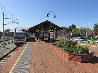
Armadale railway station is located on the South Western Railway, 30 kilometres from Perth station serving the suburb of Armadale, Brookdale and Haynes. It is the terminating point for Transperth Armadale line services and a calling point for Transwa Australind services.

Byford is a suburb on the south-eastern edge of Perth, Western Australia, within the Shire of Serpentine-Jarrahdale. The town has its origins in a township that was gazetted under the name "Beenup" in 1906. In 1920, the name of the township was changed to Byford.

Champion Lakes is a suburb of Perth, Western Australia in the City of Armadale.

Forrestdale is a suburb of Perth, Western Australia, located within the City of Armadale. It is named after John Forrest, the first premier of Western Australia.

Canning Vale is a southern suburb of Perth, 22 km (13.7 mi) from the central business district. Its local government areas are the City of Canning and the City of Gosnells.

Mount Richon is a suburb of Perth, Western Australia in the City of Armadale. Formerly part of Armadale and Wungong, Mount Richon was approved as a suburb in 2003. It occupies the western slope of the Darling Range from the intersection of Albany and South Western Highways south to Leys Rise, is bounded on the west by South-Western Highway and is bounded on the east by Albany Highway and Bungendore Park. Mount Richon is named after a vineyard that formerly existed in the area.
Mount Nasura is a suburb of Perth, Western Australia, located within the City of Armadale. The suburb occupies hilly terrain bounded on the north by Brookton Highway and Hill Street (1.6 km), west by Paterson Road (1.1 km), south-west by Canns and Carradine Roads (1.6 km), south by property boundaries on the north side of the Neerigin Brook (0.3 km), and east by Albany Highway (2.7m). With the exception of the Armadale Kelmscott District Memorial Hospital, the suburb is primarily residential.
Camillo is a southeastern suburb of Perth, Western Australia. Its local government area is the City of Armadale and it was part of Kelmscott until 1978. It was named after Camillo Cyrus, the child of Gertrude Seeligson, a local property owner in the area in 1901. Until mid-2008, it was named Westfield, named after a siding on the Jandakot railway line.

Banjup is a suburb of Perth, Western Australia, located within the City of Cockburn. Its postcode is 6164. It is approximately 25 km (16 mi) south of the Perth central business district.
Maddington is a suburb 20 kilometres (12 mi) southeast of the central business district of Perth, the capital of Western Australia, within the City of Gosnells local government area. Maddington is a mixed-use suburb containing major residential, retail and industrial sections as well as some semi-rural areas.

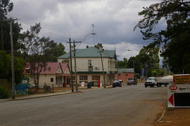
Jarrahdale is a small historic town located 45 km south-east of Perth, Western Australia in the Darling Range. The name is derived from its situation in a jarrah forest. Established in the late 1800s as the state's first major timber milling operation, it played a key role in the development of Western Australia through the exportation of jarrah around the world. At the 2016 census, Jarrahdale had a population of 1,192. Since 2001, the historic precinct has been managed by the state's National Trust organisation alongside private residential and tourism-oriented developments.

Seville Grove is a suburb of Perth, Western Australia in the City of Armadale.
Darling Downs is an outer south-eastern suburb of Perth, Western Australia, within the Shire of Serpentine-Jarrahdale. The name, referring to the suburb's proximity to the Darling Scarp, was first used as an estate name in 1977, and adopted as a suburb name in 1997.

Cardup is an outer suburb of the Western Australian capital city of Perth, located in the Shire of Serpentine-Jarrahdale to the north of the town Mundijong. In the 2011 census, it had a population of 972 people.
Hilbert is a suburb of Perth, Western Australia, located within the City of Armadale. This rural and semi-rural suburb is located on the city's fringe, and in the 2010s began to be subdivided for urban purposes.
Haynes is a suburb of Perth, Western Australia, located within the City of Armadale. This rural and semi-rural suburb is located on the city's fringe, and in the 2010s began to be subdivided for urban purposes.

Treeby is a southern suburb of Perth, Western Australia, located within the City of Cockburn. It is located on the east side of the Kwinana Freeway, close to Cockburn Central.