Watermans Bay, Western Australia

Last updated

Watermans Bay
Perth,  Western Australia
Waterman ocean view.jpg
View towards the ocean at sunset from Watermans Bay
Metropolitan Perth.svg
Red pog.svg
Watermans Bay
Coordinates 31°51′04″S115°45′29″E / 31.851°S 115.758°E / -31.851; 115.758 Coordinates: 31°51′04″S115°45′29″E / 31.851°S 115.758°E / -31.851; 115.758
Population1,281 (2016 census) [1]
 • Density754/km2 (1,950/sq mi)
Established1918
Postcode(s) 6020
Area1.7 km2 (0.7 sq mi)
Location18 km (11 mi) NW of Perth
LGA(s) City of Stirling
State electorate(s) Carine
Federal Division(s) Stirling
Suburbs around Watermans Bay:
Marmion Duncraig
Indian Ocean Watermans Bay Carine
North Beach Karrinyup

Watermans Bay is a northern coastal suburb of Perth, the capital city of Western Australia. Its local government area is the City of Stirling.

Contents

History

The area originally formed part of the Hamersley Estate, which also included the suburbs now known as Carine, North Beach and modern-day Hamersley. These areas were owned by the Hamersley family, who arrived from Europe to settle in the Swan River Colony in 1837. The Hamersleys built a summer home just south of Waterman called "The Castle" in 1865, where their large family, as well as the Perth elite, congregated for summer holidays. [2] Many of the street names in the suburb honour members of the Hamersley family, including Ethel, Margaret, Mary, Ada and Elsie.

Originally set aside as a timber reserve, the area was first settled by pastoralists in the 1860s. It served as a stopping point and watering hole along the Coastal Stock Route between Dongara and Fremantle. Cattle drovers frequented the area and Afghan camel drivers were a common sight after the opening of the goldfields in the 1890s.

In 1908, the first house in modern-day Watermans Bay was built by a business man come recreational fisherman, Alfred Waterman, who named his house "Zephyr". The beach front adjacent to his house became known as Watermans Bay, which became a popular fishing spot. [3] The only way into the area at this time was via a wooden block road built by convicts (later Wanneroo Road) and then along a limestone track to North Beach, although numerous tracks through the bushland were developed as time progressed.

In 1918, the area was subdivided as the Mt Flora Estates, but initial development was largely limited to holiday shacks. After World War II, the area developed rapidly, and in 1954, the postal district of Watermans Bay was approved. [4] By 1961, nearly all of the existing suburb had been built and settled.

Name controversy

In 1962, the name Watermans Bay was shortened to Waterman because it did not comply with WA state government regulations at the time it was not, strictly speaking, a bay. This move was unpopular with local residents, who lobbied to revert the name. In November 2003, the Geographic Names Committee accepted a City of Stirling proposal to return to the original name following a survey of Waterman households, 491 of whom supported the proposal and 11 of whom opposed it. [3] It is in fact a "bay", divided by onshore cliffs and offshore reefs to north and south with a wide sandy beach, and a place to launch fishing boats.

Star Swamp Bushland Reserve Star Swamp, Western Australia.jpg
Star Swamp Bushland Reserve

Star Swamp

Star Swamp Bushland Reserve is a bushland reserve occupying about half of the land area of the suburbs of Watermans Bay and North Beach. The precise origin of the name is unknown, but the earliest known use of the name was on a lease application by J.H.Okely of Wanneroo in 1868. It also has a long history as a Noongar camping area, with fresh water and abundant bush tucker and seafood. Some signs of the people are still there. In 1987, the State Government set aside 96 hectares as an A-class reserve, [5] and funding from the Bicentennial Commemorative Program and assistance from local organisations facilitated the establishment of the Star Swamp Heritage Trail within the reserve. [2]

Geography

Watermans Bay is bounded by the Beach Road coastal segment to the north, Marmion Avenue to the east, Hale Street to the south and West Coast Drive and the ocean to the west. Star Swamp sits east of Hope Street and represents just over half of the suburb. Reid Highway ends at the southeastern corner, and is the suburb's outlet to the Mitchell Freeway and the Perth central business district. [6]

At the 2006 Australian census, Waterman had a population of 1,195 people living in 494 dwellings, with an average age of 45 years (the third-oldest in the northern suburbs). [1] Residential styles in Watermans Bay range from timber and fibro workers' homes to modern two storey dwellings constructed of brick. [4] Due to its small size and surroundings, it is one of the most expensive of the northern suburbs in Perth.

View over Waterman from Mount Flora Lookout OIC north beach mt flora view N.jpg
View over Waterman from Mount Flora Lookout

Facilities

Watermans Bay is a residential suburb, relying on a shop on West Coast Drive and nearby shops in Marmion, North Beach and Duncraig for basic commercial services, and nearby Karrinyup Shopping Centre for other services. The suburb contains no schools, but Marmion Primary School is just beyond its northern boundary.

Star Swamp Bushland Reserve is accessible from the eastern edge of the suburb. The WA Marine Research Laboratories are located on the beach off Elvire Street, and until recently[ when? ] were the headquarters of the Research Division of the WA Department of Fisheries, which moved to Hillarys in June 2005. [7] The site has since become the home of the department's International Operations Branch.

On the southern boundary, on Elvire Street, is the Mount Flora Regional Museum, built in 1936 as a water tower at the highest point of the suburb to provide scheme water to surrounding areas. It was phased out of service in the 1970s, and converted to a museum and lookout in May 1986. It now details the region's history, and is home to the North Suburban Historical Society.

Transport

Watermans Bay is served by the 423 bus between Warwick and Stirling train stations, operated by Swan Transit. [8]

Politics

Watermans Bay is a reasonably affluent suburb with a large elderly population. It consistently supports the Liberal Party at both federal and state elections.

2004 federal election
Source: AEC
  Liberal 61.0%
  Labor 27.2%
  Greens 7.47%
  CDP 1.93%
  One Nation 0.96%
2001 federal election
Source: AEC
  Liberal 59.7%
  Labor 25.7%
  Greens 9.17%
  Democrats 2.46%
  One Nation 1.79%
1998 federal election
Source: AEC
  Liberal 54.8%
  Labor 30.0%
  One Nation 4.85%
  Greens 4.85%
  Democrats 4.73%
2005 state election
Source: WAEC
  Labor 52.1%
  Liberal 32.0%
  Greens 12.4%
  CDP 3.5%
2001 state election
Source: WAEC
  Liberal 41.8%
  Labor 26.4%
 Independent13.4%
  Greens 8.12%
  One Nation 4.97%
1996 state election
Source: WAEC
  Liberal 43.4%
 Independent25.8%
  Labor 20.3%
 Independent6.37%
  Greens 4.00%

Related Research Articles

City of Stirling Local government area in Western Australia

The City of Stirling is a local government area in the northern suburbs of the Western Australian capital city of Perth about 10 kilometres (6 mi) north of Perth's central business district. The City covers an area of 105.2 square kilometres (40.6 sq mi) and had a population of over 210,000 as at the 2016 Census, making it the largest local government area by population in Western Australia.

Carine, Western Australia Suburb of Perth, Western Australia

Carine is a suburb of Perth, the capital city of Western Australia, and is located 14 kilometres (9 mi) north of Perth's central business district (CBD) between Marmion Avenue and Mitchell Freeway. Its local government area is the City of Stirling.

Gwelup, Western Australia Suburb of Perth, Western Australia

Gwelup is a suburb of Perth, the capital city of Western Australia 12 km north of Perth's central business district (CBD) along the Mitchell Freeway. Its local government area is the City of Stirling.

Hamersley, Western Australia Suburb of Perth, Western Australia

Hamersley is a residential suburb 14 kilometres north-northwest of the central business district of Perth, the capital of Western Australia, and six kilometres (4 mi) from the Indian Ocean. The suburb adjoins two major arterial roads—Mitchell Freeway to the west and Reid Highway to the south—and is within the City of Stirling local government area. It was built during the late 1960s and 1970s as part of the Government of Western Australia's response to rapidly increasing land prices across the metropolitan area.

Karrinyup, Western Australia Suburb of Perth, Western Australia

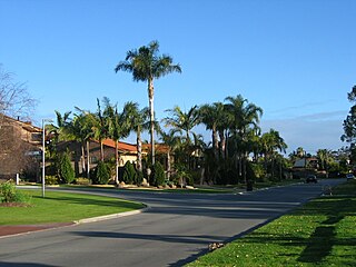
Karrinyup is a suburb of Perth, the capital city of Western Australia, and is located 12 km north of Perth's central business district. Its local government area is the City of Stirling.

North Beach, Western Australia Suburb of Perth, Western Australia

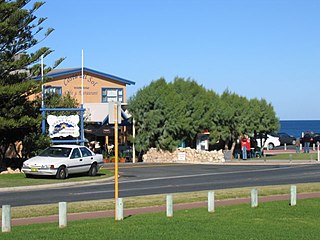
North Beach is a northern coastal suburb of Perth, the capital city of Western Australia 16 kilometres (10 mi) from Perth's central business district via Mitchell Freeway and Reid Highway. Its local government area is the City of Stirling.

City of Wanneroo Local government area in Western Australia

The City of Wanneroo is a local government area with city status in the northern suburbs of Perth, Western Australia. It is centred approximately 25 kilometres (15.5 mi) north of Perth's central business district and forms part of the northern boundary of the Perth metropolitan area. Wangara encompasses the federal divisions of Cowan, Moore and Pearce.

Hamersley family

The Hamersley family were a wealthy and well-connected family of early settlers in the colony of Western Australia. Members of the Hamersley family emigrated to Western Australia from England in 1837.

Duncraig, Western Australia Suburb of Perth, Western Australia

Duncraig is a northern suburb of Perth, the capital city of Western Australia, and is located 16 kilometres (10 mi) north of Perth's central business district (CBD) between Marmion Avenue and Mitchell Freeway. Its local government area is the City of Joondalup.

Eglinton, Western Australia Suburb of Perth, Western Australia

Eglinton is a newly populated locality in the Western Australian capital city of Perth, located approximately 44 kilometres (27 mi) north of Perth's central business district on the Indian Ocean. For the most part, the suburb is covered in native banksia woodland, scrubland and heath typical of the Swan Coastal Plain. However, in recent years, there has been growth in residential estates, with a town centre to be built in the near future. There are also plans for the Joondalup train line to be extended through the suburb with Eglinton Station to be located inside Allara estate.

Mindarie, Western Australia Suburb of Perth, Western Australia

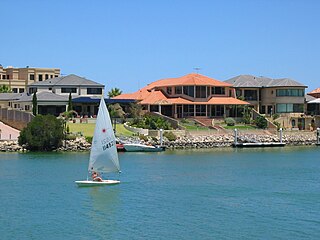
Mindarie is an outer coastal suburb of Perth, Western Australia. It is located 36 kilometres (22 mi) north of Perth's central business district, and forms part of the City of Wanneroo local government area.

Tamala Park, Western Australia Suburb of Perth, Western Australia

Tamala Park is an unpopulated locality in Perth, Western Australia. It sits on the border between the City of Wanneroo and the City of Joondalup local authorities, and separates the Clarkson-Butler region from the suburbs of Joondalup.

Merriwa, Western Australia Suburb of Perth, Western Australia

Merriwa is a coastal, northern suburb of Perth, Western Australia, 36 kilometres (22 mi) north of the central business district. It is part of the City of Wanneroo local government area. It is a predominantly residential suburb, containing two RAAF retirement villages.

Hillarys, Western Australia Suburb of Perth, Western Australia

Hillarys is a northern coastal suburb of Perth, the capital city of Western Australia, in the local government area of the City of Joondalup. It is part of the Whitfords precinct, and is located 21 km north-northwest of Perth's central business district via Mitchell Freeway and Hepburn Avenue.

Burns Beach, Western Australia Suburb of Perth, Western Australia

Burns Beach is a suburb of Perth, Western Australia, located 34 kilometres (21 mi) north of Perth's central business district at the northern fringe of the City of Joondalup. Burns Beach has maintained much of its original character as a small coastal village even with its loss of isolation, and the beach is popular among hang gliding enthusiasts.

Wanneroo Road

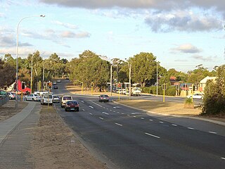
Wanneroo Road is a 44-kilometre (27 mi) arterial highway in the northern suburbs of Perth, Western Australia linking Joondanna and Yokine in the south with Wanneroo and Yanchep in the north. As part of State Route 60, it begins from Charles Street in the inner city and becomes Indian Ocean Drive up to Dongara.

Marmion Avenue

Marmion Avenue is a 40-kilometre (25 mi) arterial road in the northern coastal suburbs of Perth, Western Australia, linking Trigg in the south with Yanchep in the north. It forms part of State Route 71 along with West Coast Highway, which it joins onto at its southern terminus.

Alexander Drive

Alexander Drive is a major north–south arterial road in the northern suburbs of Perth, Western Australia, connecting Perth's central business district (CBD) with Edith Cowan University's Mount Lawley campus and the Malaga industrial area, as well as newer development suburbs to Perth's north. It is used by Transperth bus routes, including the 360, 361 and 362. Alexander Drive was named after Mr S.B. Alexander, a former Wanneroo Road Board member. Alexander Drive runs through the following local government areas City of Wanneroo, City of Swan, City of Bayswater and City of Stirling.

Beach Road, Perth

Beach Road is a major east-west road in the northern suburbs of Perth, Western Australia, connecting Perth's inner northern beachside suburbs and inland state housing areas with shopping and public transport facilities at Warwick and the Malaga industrial area. It was mostly built between 1967 and 1974, and is a dual carriageway for most of its length, except for a small western part between Marmion Avenue and the coast, which is a minor residential distributor road and is discontinuous at Marmion Avenue. Beach Road also serves as a local government boundary. From Alexander Drive to Wanneroo Road, Beach Road is the boundary with the City of Wanneroo on the northern side and the City of Stirling on the southern side. From Wanneroo Road to the coast Beach Road is the boundary with the City of Joondalup on the northern side and the City of Stirling on the southern side.

Star Swamp

Star Swamp Bushland Reserve is a bushland reserve occupying about half of the land area of the suburbs of Watermans Bay and North Beach in the northern suburbs of Perth, Western Australia. The precise origin of the name is unknown, but the earliest known use of the name was on a lease application by J.H.Okely of Wanneroo in 1868.

References

  1. 1 2 Australian Bureau of Statistics (27 June 2017). "State Suburbs: Watermans Bay". 2016 Census QuickStats. Retrieved 25 August 2020. OOjs UI icon edit-ltr-progressive.svg
  2. 1 2 Heritage Council of WA (June 1999). "Heritage Trail - Star Swamp" (PDF). Retrieved 15 September 2006.
  3. 1 2 Western Australian Land Information Authority. "History of metropolitan suburb names – W" . Retrieved 17 April 2007.
  4. 1 2 City of Stirling. "Suburbs - Watermans Bay" . Retrieved 17 January 2007.
  5. "Naming of Star Swamp (per 3129/977 V3)". Western Australia Government Gazette. 3 April 1987. p. 1987:1246.
  6. Department of Land Information. StreetSmart Perth Street Directory (54th ed.). West Australian Newspapers Ltd. pp. Map 280/310. ISBN   978-0-909439-67-5.
  7. Department of Fisheries (WA) (November 2005). "Overview of the Research Division" . Retrieved 17 January 2007.
  8. Northern 62 timetable, Transperth, effective 8 August 2005. Accessed 17 January 2007.