Marmion, Western Australia

Last updated

Marmion
Perth,  Western Australia
Marmion streets Radbourn W to Cliverton.jpg
Radbourn Street, Marmion
Marmion, Western Australia
Coordinates 31°50′24″S115°45′22″E / 31.84°S 115.756°E / -31.84; 115.756
Population2,390 (SAL 2021) [1]
Established1970s
Postcode(s) 6020
Area1.2 km2 (0.5 sq mi)
Location17 km (11 mi) NW of Perth
LGA(s) City of Joondalup
State electorate(s) Carine
Federal division(s) Moore
Suburbs around Marmion:
Sorrento Duncraig
Indian Ocean Marmion Duncraig
Watermans Bay Carine

Marmion is a northern coastal suburb of Perth, the capital city of Western Australia. Its local government area is the City of Joondalup.

Contents

History

Marmion was named after Patrick Marmion, master whaler, who operated a whaling station in the area in 1849. There are still some remains of the old whaling station in the adjacent suburb, Sorrento. [2] A monument to Marmion can be found in Geneff Park in Padbury Circle, Sorrento.

Prior to white settlement, the Whadjuk Aboriginal people, who called the area Mooro, gathered abalone and other shellfish in large numbers off the nearby reefs.

The area was popular with fishermen in the 1930s, and numerous boatsheds and shacks were built there, as well as a whaling station. A townsite was gazetted in the area in 1940, [3] but it remained largely undeveloped until the late 1950s, when the postal district of Marmion was approved. At first, the only development in the area was the primary school, opened in 1956 as a two-teacher school and nicknamed "The Little School in the Bush", accessible only by a track until the mid-1970s. By 1961, the area west of Cliff Street was largely developed, and the Marmion Angling and Aquatic Club had been established. The rest of the suburb was developed between 1973 and 1976.

Geography

Marmion is bounded by High Street and Freeman Way to the north, Marmion Avenue to the east, the Beach Road coastal segment to the south and West Coast Drive and the ocean to the west. [4]

At the 2006 Australian census, Marmion had a population of 2,106 people living in 736 dwellings. [5]

Marmion Village shopping centre Marmion shops in 2006.jpg
Marmion Village shopping centre

Facilities

Marmion is a residential suburb, relying on the Marmion Village shopping centre in Sheppard Way for basic commercial services, and Karrinyup Shopping Centre and Centro Warwick for other services. The suburb is served by the Marmion Primary School and falls within Carine Senior High School's catchment area. Braden Park, a large park with play equipment and lighting, is situated near the shopping centre. [4]

The Marmion Angling and Aquatic Club is a boating and fishing club located above Marmion Beach, which has a function room overlooking the Indian Ocean. Off the coast is the Marmion Marine Park, [6] which provides a home for many species of marine animals.

Transport

Marmion's west is served by the Transperth 423 bus route between Warwick and Stirling, [7] while the 441 bus along Marmion Avenue [8] serves the eastern part of the suburb. All bus services are operated by Swan Transit.

Politics

Marmion is a reasonably affluent suburb with a large elderly population.[ citation needed ] It consistently supports the Liberal Party at both federal and state elections.

Education

Marmion has one state public school, Marmion Primary School, which caters for kindergarten through to year 6.

Related Research Articles

<span class="mw-page-title-main">Carine, Western Australia</span> Suburb of Perth, Western Australia

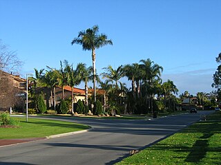
Carine is a suburb of Perth, the capital city of Western Australia, and is located 14 kilometres (9 mi) north of Perth's central business district (CBD) between Marmion Avenue and Mitchell Freeway. Its local government area is the City of Stirling.

<span class="mw-page-title-main">Hamersley, Western Australia</span> Suburb of Perth, Western Australia

Hamersley is a residential suburb 14 kilometres north-northwest of the central business district of Perth, the capital of Western Australia, and six kilometres (4 mi) from the Indian Ocean. The suburb adjoins two major arterial roads—Mitchell Freeway to the west and Reid Highway to the south—and is within the City of Stirling local government area. It was built during the late 1960s and 1970s as part of the Government of Western Australia's response to rapidly increasing land prices across the metropolitan area.

<span class="mw-page-title-main">Karrinyup, Western Australia</span> Suburb of Perth, Western Australia

Karrinyup is a suburb of Perth, the capital city of Western Australia, and is located 12 km north of Perth's central business district. Its local government area is the City of Stirling.

<span class="mw-page-title-main">North Beach, Western Australia</span> Suburb of Perth, Western Australia

North Beach is a northern coastal suburb of Perth, the capital city of Western Australia 16 kilometres (10 mi) from Perth's central business district via Mitchell Freeway and Reid Highway. Its local government area is the City of Stirling.

<span class="mw-page-title-main">Yokine, Western Australia</span> Suburb of Perth, Western Australia

Yokine is a suburb of Perth, Western Australia. Its local government area is the City of Stirling.

<span class="mw-page-title-main">Peppermint Grove, Western Australia</span> Suburb of Perth, Western Australia

Peppermint Grove is an affluent western suburb of Perth, Western Australia on the north bank of the Swan River at Freshwater Bay. Its local government area, the smallest in the country, is the Shire of Peppermint Grove. The suburb was named after its trademark Swan River peppermint trees lining many streets. The suburb has long been associated with Western Australia's wealthiest and oldest families. Their prosperity is reflected in the many historical houses in the area, such as The Cliffe and the Federation Queen Anne style St Just. Colin Barnett, a former Premier of Western Australia, dubbed the suburb "Monaco of WA" due to its small size and concentration of wealth.

<span class="mw-page-title-main">Edgewater, Western Australia</span> Suburb of Perth, Western Australia

Edgewater is a suburb of Perth, Western Australia 23 kilometres (14 mi) north of Perth's central business district. Edgewater was approved as a suburb name in 1974, and its local government area is the City of Joondalup. It is named after its location on the western edge of Lake Joondalup, which is surrounded by Yellagonga Regional Park.

<span class="mw-page-title-main">Currambine, Western Australia</span> Suburb of Perth, Western Australia

Currambine is a northern suburb of Perth, the capital city of Western Australia, 29 km north of Perth's central business district. Its local government area is the City of Joondalup. It contains the Currambine Central shopping centre and a Hoyts cinema complex.

<span class="mw-page-title-main">Sorrento, Western Australia</span> Suburb of Perth, Western Australia

Sorrento is a northern coastal suburb of Perth, the capital city of Western Australia in the local government area of the City of Joondalup. At its northwestern corner is the Hillarys Boat Harbour, built in the late 1980s.

<span class="mw-page-title-main">Watermans Bay, Western Australia</span> Suburb of Perth, Western Australia

Watermans Bay is a northern coastal suburb of Perth, the capital city of Western Australia. Its local government area is the City of Stirling.

<span class="mw-page-title-main">Duncraig, Western Australia</span> Suburb of Perth, Western Australia

Duncraig is a northern suburb of Perth, the capital city of Western Australia, and is located 16 kilometres (10 mi) north of Perth's central business district (CBD) between Marmion Avenue and Mitchell Freeway. Its local government area is the City of Joondalup.

<span class="mw-page-title-main">Yanchep</span> Suburb of Perth, Western Australia

Yanchep is an outer coastal suburb of Perth, Western Australia, 56 kilometres (35 mi) north of the Perth CBD. It is a part of the City of Wanneroo local government area. Originally a small crayfishing settlement, it was developed by entrepreneur Alan Bond in the 1970s for the 1977 America's Cup. The area covers the urban centre of Yanchep as well as Yanchep National Park in its entirety.

<span class="mw-page-title-main">Clarkson, Western Australia</span> Suburb of Perth, Western Australia

Clarkson is an outer northern suburb of Perth, Western Australia, located 34 kilometres north of Perth's central business district in the City of Wanneroo.

<span class="mw-page-title-main">Jindalee, Western Australia</span> Suburb of Perth, Western Australia

Jindalee is an outer coastal suburb of Perth, Western Australia, located approximately 40 kilometres (25 mi) north of the Perth central business district. Its local government area is the City of Wanneroo.

<span class="mw-page-title-main">Quinns Rocks, Western Australia</span> Suburb of Perth, Western Australia

Quinns Rocks is an outer coastal suburb of Perth, Western Australia, located 38 kilometres (24 mi) north of Perth's central business district. It is part of the City of Wanneroo local government area. The suburb was formally established in 1962 as a rural townsite, focused around Quinns Beach, the area's main amenity.

<span class="mw-page-title-main">Ridgewood, Western Australia</span> Suburb of Perth, Western Australia

Ridgewood is an outer suburb of Perth, Western Australia, located 37 kilometres north of Perth's central business district. It is part of the City of Wanneroo local government area.

<span class="mw-page-title-main">Two Rocks</span> Suburb of Perth, Western Australia

Two Rocks is an outer suburb at the northern edge of Perth, the state capital of Western Australia, located 61 kilometres (38 mi) northwest of the city's central business district. It is part of the City of Wanneroo local authority and represents the furthest northern extent of the Perth metropolitan region.

Hillarys is a northern coastal suburb of Perth, the capital city of Western Australia, in the local government area of the City of Joondalup. It is part of the Whitfords precinct, and is located 21 km north-northwest of Perth's central business district via Mitchell Freeway and Hepburn Avenue.

<span class="mw-page-title-main">Burns Beach, Western Australia</span> Suburb of Perth, Western Australia

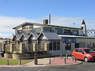
Burns Beach is a suburb of Perth, Western Australia, located 34 kilometres (21 mi) north of Perth's central business district at the northern fringe of the City of Joondalup. Burns Beach has maintained much of its original character as a small coastal village even with its loss of isolation, and the beach is popular among hang gliding enthusiasts.

<span class="mw-page-title-main">Stirling, Western Australia</span> Suburb of Perth, Western Australia

Stirling is a suburb of Perth, the capital city of Western Australia, about 10 km north of Perth's central business district (CBD) along the Mitchell Freeway. Its local government area is the City of Stirling, whose council offices and administration centre are located in the southwest of the mostly residential suburb.

References

  1. Australian Bureau of Statistics (28 June 2022). "Marmion (Suburb and Locality)". Australian Census 2021 QuickStats. Retrieved 28 June 2022.  OOjs UI icon edit-ltr-progressive.svg
  2. "History of metropolitan suburb names – M". Western Australian Land Information Authority. Archived from the original on 16 March 2022. Retrieved 17 January 2007. Incorrectly references Peter Marmion.
  3. "New Townsite - Marmion (per 940/36)". Western Australia Government Gazette. 5 April 1940. p. 1940:474.
  4. 1 2 Department of Land Information. StreetSmart Perth Street Directory (54th ed.). West Australian Newspapers Ltd. pp. Map 280. ISBN   978-0-909439-67-5.
  5. Australian Bureau of Statistics (27 June 2017). "State Suburbs: Marmion". 2016 Census QuickStats. Retrieved 25 August 2020. OOjs UI icon edit-ltr-progressive.svg
  6. Conservation & Land Management (WA) (20 September 2005). "Marmion Marine Park". Archived from the original on 19 September 2006. Retrieved 17 January 2007.
  7. Northern 62 timetable Archived 30 September 2007 at the Wayback Machine , Transperth, effective 8 August 2005. Accessed 17 January 2007.
  8. Northern 63 timetable Archived 28 September 2007 at the Wayback Machine , Transperth, effective 1 October 2006. Accessed 17 January 2007.