Beldon, Western Australia

Last updated

Beldon
Perth,  Western Australia
Beldon, Western Australia
Coordinates 31°46′26″S115°46′05″E / 31.774°S 115.768°E / -31.774; 115.768
Population4,094 (SAL 2021) [1]
Established1975
Postcode(s) 6027
Area2.2 km2 (0.8 sq mi)
Location25 km (16 mi) NNW of Perth
LGA(s) City of Joondalup
State electorate(s) Hillarys
Federal division(s) Moore
Suburbs around Beldon:
Ocean Reef Heathridge Edgewater
Mullaloo Beldon Woodvale
Kallaroo Craigie Woodvale

Beldon is a small suburb of Perth, Western Australia, located within the City of Joondalup, to the north of Craigie.

Contents

Etymology

There are two possible origins for naming the suburb Beldon. The first possible origin is that it is named after A.W. Beldon who was an early landowner and surveyor of the Wanneroo area, active around 1838. [2] [3] :4 The second possibility is that it is named after Arthur and Florence Beldon who ran Wanneroo School from 1945 until 1965. [3] :4

History

Prior to white settlement in Western Australia, the land was inhabited by the Nyoongar aboriginal people for 40,000 years and who had crisscrossed the area from inland to the coast during various times of the year. [3] :4

When the suburb was proposed in 1974, Albert Grove was suggested as a name after one of the co-developers Jennings Industries which was owned by Sir Albert V Jennings. [2] [3] :4 But this name was objected to as there was another suburb called Albert Cove, so another suggestion was put forward. [4] Beldon's name was approved on 25 August 1975. [2] [4] [3] :4 House and land packages were first advertised in 1977 with the area known until 1979 as Mullaloo-Beldon or Ocean Reef-Beldon. [3] :4 The first show-houses were built along Craigie Drive and the area was marketed to young families, couples and migrants. [3] :4

Economy

Retail

The suburb has two main shopping precincts. The Belridge City shopping centre is located in the northern part of the suburb. Beldon Shopping Centre is located to the western side and is the original shopping centre in the suburb having opened on 5 December 1977 as Mullaloo Woolworths. [3] :4 In 1991, Belridge Professional Centre was opened and currently has chiropractic, medical, physiotherapy and veterinary facilities. [3] :4 The Belridge shopping centre opened in July 1994. [5]

Governance

The suburb of Beldon falls under the local government of the City of Joondalup and is represented by two councillors from the Central Ward. The current councillors are Rebecca Pizzey and Christopher May. [6] At state parliament level, Beldon is represented in the Western Australian Legislative Assembly by a member from Hillarys electoral district. The current member is Caitlin Collins. In the Australian federal parliament, the suburb is part of the Division of Moore and is currently represented by member, Ian Goodenough.

Amenities

Parks

Beldon also contains several parks, with most of them containing play equipment for children. Beldon Park, the main park has a multi-purpose sports field and children's play equipment. Haddington Park, that features a dirt bike track. And two smaller parks, Gradient Park and Sandalford Park.

Infrastructure

Transport

Bus

The suburb is served by the 463 Transperth bus route, as well as two others, the 462 and 464, that all start and end at the Joondalup and Whitfords railway stations.

Rail

Though not directly served, the nearest train station is Edgewater railway station which is part of the Joondalup line.

Roads

Beldon is located in between two major North-South arteries, Marmion Avenue to the west and the Mitchell Freeway to the east. Adjacent to the north is Ocean Reef Road which connects Beldon to the beach in the west (about 3 km) and inland parts, such as the Swan Valley.

Education

Schools

The suburb hosts two schools. Beldon Primary School which opened in 1985 and Belridge Senior High School which opened in 1991 and was fully established in 1995. [3] :4

Related Research Articles

<span class="mw-page-title-main">Currambine, Western Australia</span> Suburb of Perth, Western Australia

Currambine is a northern suburb of Perth, the capital city of Western Australia, 29 km north of Perth's central business district. Its local government area is the City of Joondalup.

<span class="mw-page-title-main">Butler, Western Australia</span> Suburb of Perth, Western Australia

Butler is an outer suburb of Perth, Western Australia, 41 kilometres north of Perth's central business district. It is part of the City of Wanneroo local government area. It forms the majority of the Brighton Estate, a large commercial and residential development by Satterley.

<span class="mw-page-title-main">Clarkson, Western Australia</span> Suburb of Perth, Western Australia

Clarkson is an outer northern suburb of Perth, Western Australia, located 34 kilometres north of Perth's central business district in the City of Wanneroo.

<span class="mw-page-title-main">Neerabup, Western Australia</span> Suburb of Perth, Western Australia

Neerabup is a rural locality in Perth, the capital of Western Australia, within the local government area of the City of Wanneroo.

<span class="mw-page-title-main">Pearsall, Western Australia</span> Suburb of Perth, Western Australia

Pearsall is a suburb of Perth, Western Australia in the City of Wanneroo. Until the late 1990s it was the southernmost part of the suburb of Wanneroo.

Sinagra is an outer northern suburb of Perth, Western Australia, located within the City of Wanneroo.

Tapping is a suburb of Perth, Western Australia, located within the City of Wanneroo. It came into being in the early 1990s as a subdivision of Wanneroo, originally as part of the Carramar estate.

<span class="mw-page-title-main">Wangara, Western Australia</span> Suburb of Perth, Western Australia

Wangara is a light industrial suburb of Perth, Western Australia, located within the City of Wanneroo.

Craigie is a northern suburb of Perth. Craigie was chosen as a suburb name in 1970 and honours an early councillor of the City of Wanneroo who did work in developing the City. Craigie is one of the four "Whitfords" suburbs that resulted from the State Government rezoning a large area of coastal land for development in 1969.

Heathridge is a suburb of Perth, Western Australia, located 33 kilometres (21 mi) south of Yanchep within the City of Joondalup.

Hillarys is a northern coastal suburb of Perth, the capital city of Western Australia, in the local government area of the City of Joondalup. It is part of the Whitfords precinct, and is located 21 km north-northwest of Perth's central business district via Mitchell Freeway and Hepburn Avenue.

<span class="mw-page-title-main">Marmion, Western Australia</span> Suburb of Perth, Western Australia

Marmion is a northern coastal suburb of Perth, the capital city of Western Australia. Its local government area is the City of Joondalup.

<span class="mw-page-title-main">Woodvale, Western Australia</span> Suburb of Perth, Western Australia

Woodvale is a suburb of Perth, Western Australia, located within the City of Joondalup and the City of Wanneroo. At the 2016 census Woodvale had a population of 9,276.

<span class="mw-page-title-main">Mullaloo, Western Australia</span> Suburb of Perth, Western Australia

Mullaloo is a northern coastal suburb of Perth, Western Australia, within the City of Joondalup.
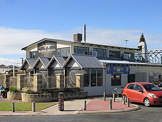
<span class="mw-page-title-main">City of Joondalup</span> Local government area in Western Australia

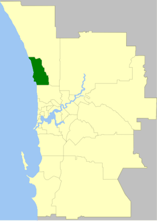
The City of Joondalup is a local government area in Perth, Western Australia. Its central business district is located in the suburb Joondalup, and it includes the town centres of Hillarys and Warwick.

<span class="mw-page-title-main">Belridge Secondary College</span> School in Perth, Western Australia

Belridge Secondary College is a comprehensive independent public co-educational high day school, located in Beldon, 3.8 kilometres (2.4 mi) south of Joondalup in the northern suburbs of Perth, Western Australia.

<span class="mw-page-title-main">Marmion Avenue</span> Road in Perth, Western Australia

Marmion Avenue is a 40-kilometre (25 mi) arterial road in the northern coastal suburbs of Perth, Western Australia, linking Trigg in the south with Yanchep in the north. It forms part of State Route 71 along with West Coast Highway, which it joins onto at its southern terminus.

Wanneroo is a northern suburb of Perth, Western Australia, located within the City of Wanneroo.

<span class="mw-page-title-main">Ocean Reef Road</span> Road in Perth, Western Australia

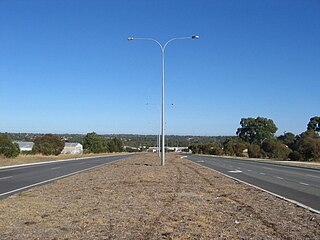
Ocean Reef Road is an arterial east-west road in Perth, Western Australia. It is located within the northern suburbs of Perth, from Ocean Reef in the west, to Landsdale in the east, with a portion travelling northwards along the coast to Iluka.

Hodges Drive is a main west–east road in Joondalup, north of Perth, Western Australia. It begins in the suburb of Ocean Reef at a T-junction with Boat Habour Quays in the Ocean Reef Marina and runs through the residential areas in Ocean Reef, Connolly and Heathridge, before terminating at Joondalup Drive. The road continues from there as Grand Boulevard. Hodges Drive is a four lane dual-carriageway for its entire length apart from a small section near the interchange with Boat Habour Quays where it becomes a 2 lane road.

References

  1. Australian Bureau of Statistics (28 June 2022). "Beldon (suburb and locality)". Australian Census 2021 QuickStats. Retrieved 28 June 2022.  OOjs UI icon edit-ltr-progressive.svg
  2. 1 2 3 "Beldon - Perth and surrounds suburb names". Landgate. Government of Western Australia. Retrieved 26 November 2018.
  3. 1 2 3 4 5 6 7 8 9 10 "The Story of Beldon - Family & Local History Newsletter" (PDF). City of Joondalup. Winter 2016. Retrieved 26 November 2018.
  4. 1 2 Sparvell, Ray (28 October 2015). "Perth's suburbs that changed their names and the stories behind them". WA Today. Retrieved 26 November 2018.
  5. Stories from the suburbs : Beldon. City of Joondalup. 2004.
  6. "Elected Members". City of Joondalup. 21 December 2023. Retrieved 21 December 2023.
  7. "Route 462". Bus Timetable 65 (PDF). Transperth. 11 January 2024 [effective from 28 January 2024].
  8. "Route 463". Bus Timetable 66 (PDF). Transperth. 24 October 2023 [effective from 17 December 2023].
  9. "Route 464". Bus Timetable 66 (PDF). Transperth. 24 October 2023 [effective from 17 December 2023].