The Marmion Marine Park is a protected area along and off the coast of northern Perth, Western Australia.
In 1987, [1] this park was declared the first marine park in Western Australia. The park covers an area of 10,500 ha, from Trigg Island in the south to Burns Beach in the north. [2]
Limestone reefs run parallel to the coastline and contain underwater limestone platforms and caves that hide many species of tropical fish.
Several other animals visit this area regularly, including the Australian sea lion and the bottlenose dolphin. Humpback whales frequent the waters in May on their journey north. When they return between September and November, they are in breeding, making them easier to see by tourists.
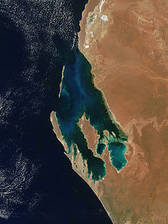
Shark Bay is a World Heritage Site in the Gascoyne region of Western Australia. The 23,000-square-kilometre (8,900 sq mi) area is located approximately 800 kilometres (500 mi) north of Perth, on the westernmost point of the Australian continent. UNESCO's official listing of Shark Bay as a World Heritage Site reads:

The City of Wanneroo is a local government area with city status in the northern suburbs of Perth, Western Australia. It is centred approximately 25 kilometres (15.5 mi) north of Perth's central business district and forms part of the northern boundary of the Perth metropolitan area. Wangara encompasses the federal divisions of Cowan, Moore and Pearce.

The Shark Bay Marine Park is protected marine park located within the UNESCO World Heritage–listed Shark Bay, in the Gascoyne region of Western Australia. The 748,725-hectare (1,850,140-acre) marine park is situated over 800 km (500 mi) north of Perth and 400 kilometres (250 mi) north of Geraldton.

Sorrento is a northern coastal suburb of Perth, the capital city of Western Australia in the local government area of the City of Joondalup. At its northwestern corner is the Hillarys Boat Harbour, built in the late 1980s.

Duncraig is a northern suburb of Perth, the capital city of Western Australia, and is located 16 kilometres (10 mi) north of Perth's central business district (CBD) between Marmion Avenue and Mitchell Freeway. Its local government area is the City of Joondalup.
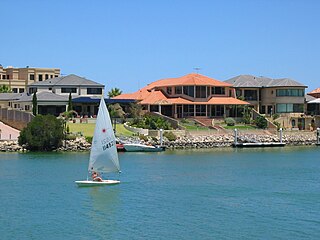
Mindarie is an outer coastal suburb of Perth, Western Australia. It is located 36 kilometres (22 mi) north of Perth's central business district, and forms part of the City of Wanneroo local government area.

Two Rocks is an outer suburb at the northern edge of Perth, the state capital of Western Australia, located 61 kilometres (38 mi) northwest of the city's central business district. It is part of the City of Wanneroo local authority and represents the furthest northern extent of the Perth metropolitan region.
Hillarys is a northern coastal suburb of Perth, the capital city of Western Australia, in the local government area of the City of Joondalup. It is part of the Whitfords precinct, and is located 21 km north-northwest of Perth's central business district via Mitchell Freeway and Hepburn Avenue.

Marmion is a northern coastal suburb of Perth, the capital city of Western Australia. Its local government area is the City of Joondalup.

Marmion Avenue is a 40-kilometre (25 mi) arterial road in the northern coastal suburbs of Perth, Western Australia, linking Trigg in the south with Yanchep in the north. It forms part of State Route 71 along with West Coast Highway, which it joins onto at its southern terminus.

The Ningaloo Coast is a World Heritage Site located in the north west coastal region of Western Australia. The 705,015-hectare (1,742,130-acre) heritage-listed area is located approximately 1,200 kilometres (750 mi) north of Perth, along the East Indian Ocean. The distinctive Ningaloo Reef that fringes the Ningaloo Coast is 260 kilometres (160 mi) long and is Australia's largest fringing coral reef and the only large reef positioned very close to a landmass. The Muiron Islands and Cape Farquhar are within this coastal zone.

The Swan Coastal Plain in Western Australia is the geographic feature which contains the Swan River as it travels west to the Indian Ocean. The coastal plain continues well beyond the boundaries of the Swan River and its tributaries, as a geological and biological zone, one of Western Australia's Interim Biogeographic Regionalisation for Australia (IBRA) regions. It is also one of the distinct physiographic provinces of the larger West Australian Shield division.

Sunset Coast is the name given by Tourism Western Australia to the coastal section of the northern metropolitan area of Perth, the capital city of Western Australia, and is one of the six component tourism precincts of the Perth region. While not in extensive use locally, since the 1990s it has been a centrepiece of Western Australian tourism planning and is used in interstate and overseas marketing of the region. The region contains many white sand beaches.
Shenton Avenue is an east-west distributor road in the northern suburbs of Perth, Western Australia, located within the City of Joondalup. The road primarily links Joondalup's coastal suburbs with the Joondalup central business district, which it passes through. It is also an entrance to the Mitchell Freeway.

The Shoalwater Islands Marine Park is a protected marine park located in Western Australia and stretches from the northern point of the Garden Island Causeway to the southern point of Becher Point. The 6,540-hectare (16,200-acre) marine park is located offshore from the suburban locality of Shoalwater.
Hodges Drive is a main west–east road in Joondalup, north of Perth, Western Australia. It begins in the suburb of Ocean Reef at a T-junction with Ocean Reef Road and runs through the residential areas in Ocean Reef, Connolly and Heathridge, before terminating at Joondalup Drive. The road continues from there as Grand Boulevard. Hodges Drive is a four lane dual-carriageway for most of its length, and changes to a two way single carriageway road west of Marmion Avenue.
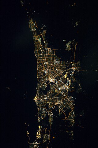
The Perth metropolitan region or the Perth metropolitan area is the administrative area and geographical extent of the Western Australian capital city of Perth and its conurbation.
Boullanger Island lies off the coast of Western Australia and covers an area of about 35 hectares. The nearest settlement is the mainland town of Jurien Bay.

Centaur was a 188-ton iron brig built in Aberdeen, Scotland, in 1849.
Little Island is a small uninhabited sand and limestone island situated in the Marmion Marine Park just off the coast of Hillarys in Perth, Western Australia. There is a small beach on the north eastern side of the island, however beaching of kayaks is not allowed and walking on the beach is discouraged. The waters around the island are a marine sanctuary, so there is always an excellent array of marine life in the area, including humpback whales, bottlenose dolphins, Australian sea lions and occasionally, wayward sea turtles. It is a site for viewing sea lions and has a snorkelling trail.
Coordinates: 31°48′04″S115°42′22″E / 31.801°S 115.706°E
| | This article about a location in Western Australia is a stub. You can help Wikipedia by expanding it. |