Division of Stirling

Last updated

Stirling
Australian House of Representatives Division
Division of STIRLING 2016.png
Division of Stirling in Western Australia, as of the 2016 federal election
Created1955
Abolished2022
Namesake Sir James Stirling
Electors 100,781 (2019)
Area74 km2 (28.6 sq mi)
DemographicInner metropolitan

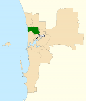
The Division of Stirling was an Australian electoral division in the inner northern and beachside suburbs of Perth, Western Australia, which included a large portion of the local government area of the City of Stirling.

Contents

History

Sir James Stirling, the division's namesake Jamesstirling.jpg
Sir James Stirling, the division's namesake

The electorate was created in the Western Australia redistribution of 10 August 1955, and was named after Sir James Stirling, the 19th-century founding lieutenant governor and governor of Western Australia. Stirling covered a demographically diverse area, including several affluent beachside suburbs, as well as working class areas further inland. As a result, Stirling was often a marginal seat, alternating between the Australian Labor Party and the Liberal Party of Australia.

Unlike some marginal seats on the east coast, such as Eden-Monaro, Stirling was not often seen as a reliable barometer for winning government. For example, longtime Labor member Harry Webb survived the massive Coalition landslide of 1966, only to become one of two Labor MPs from the state to be defeated in 1972 even as Labor ended 23 years of Coalition rule. While it elected five government MPs, all but three of its members have spent at least one term in opposition.

Besides Webb, who held the seat for all but one term from its creation in 1955 until his defeat in 1972, the seat's most prominent member was Labor's Ron Edwards, who was Deputy Speaker of the House of Representatives from 29 August 1989 to 8 February 1993. It had been expected that if the 1993 election had not been called so soon after Leo McLeay's resignation as Speaker or if Edwards had held his seat in the election upon the re-election of the Keating government, Edwards would have been elected Speaker.

Opinion polls in the leadup to the 2004 election had suggested a close result in Stirling, leaning towards the possibility of sitting Labor member Jann McFarlane retaining her seat. This was thought to have been more likely after Paul Afkos, the original Liberal candidate, was forced to resign after he was revealed to have borrowed money from a convicted drug dealer. A local businessman, Michael Keenan, was brought in as his replacement, and maintained the close difference in polling. However, on election day, the swing to the Liberal Party both statewide and nationwide was stronger than expected, and Keenan was ultimately successful in unseating McFarlane. The Stirling Times, a local newspaper, speculated in October 2006 that McFarlane, at that time a Stirling councillor, might contest the seat again in 2007. On 28 November 2006, former SAS officer and outspoken opponent of the Iraq War Peter Tinley accepted an offer from Kim Beazley to run as the ALP candidate in the 2007 election. [1] Ahead of the 2010 election, Labor preselected Louise Durack, a social worker and executive director of People With Disabilities (WA) and past candidate for the state seat of Ocean Reef, to run for the seat. Keenan was re-elected at the 2010 federal election.

It was confirmed in June 2021 that this division would be abolished at the 2022 federal election, with its area redistributed to the neighbouring divisions of Cowan, Curtin, Moore and Perth. [2] [3]

Geography

Since 1984, federal electoral division boundaries in Australia have been determined at redistributions by a redistribution committee appointed by the Australian Electoral Commission. Redistributions occur for the boundaries of divisions in a particular state, and they occur every seven years, or sooner if a state's representation entitlement changes or when divisions of a state are malapportioned. [4]

The division included the northern majority of the City of Stirling and a small portion of the City of Bayswater. Suburbs included [5]


In the redistribution that resulted in Stirling's abolition, the suburbs it contained west of the Mitchell Freeway were divided into two. In the north, the suburbs of Carine and Watermans Bay and the northern areas of Gwelup, Karrinyup and Trigg were allocated to Moore, while in the south, the remaining southern portions of Gwelup, Karrinyup and Trigg, along with Stirling's portion of Scarborough, were allocated to Curtin. East of the Mitchell Freeway, the southern fringe of the electorate, containing the suburbs of Joondanna, Tuart Hill and Yokine, along with the southern portion of Dianella, the south-east of Osborne Park, and Stirling's section of Morley, were allocated to Perth. The remainder of the electorate, approximately half of its total area, and including the suburbs of Balcatta, Balga, Hamersley, Mirrabooka, Nollamara, Stirling, and Westminster, along with the northern sections of Dianella and Morley and the north-east of Osborne Park, were allocated to Cowan. [6]

Members

ImageMemberPartyTermNotes
  HarryWebb1962.jpg Harry Webb
(1908–2000)
Labor 10 December 1955
22 November 1958
Previously held the Division of Swan. Lost seat
  Doug Cash.png Doug Cash
(1919–2002)
Liberal 22 November 1958
9 December 1961
Lost seat. Later elected to the Western Australian Legislative Assembly seat of Mirrabooka in 1968
  HarryWebb1967.jpg Harry Webb
(1908–2000)
Labor 9 December 1961
2 December 1972
Lost seat
  No image.svg Ian Viner
(1933–)
Liberal 2 December 1972
5 March 1983
Served as minister under Fraser. Lost seat
  No image.svg Ron Edwards
(1945–)
Labor 5 March 1983
13 March 1993
Lost seat
  No image.svg Eoin Cameron
(1951–2016)
Liberal 13 March 1993
3 October 1998
Lost seat
  No image.svg Jann McFarlane
(1944–)
Labor 3 October 1998
9 October 2004
Lost seat
  Michael Keenan 2017.jpg Michael Keenan
(1972–)
Liberal 9 October 2004
11 April 2019
Served as minister under Abbott, Turnbull and Morrison. Retired
  Vince Connelly.jpg Vince Connelly
(1978–)
Liberal 18 May 2019
11 April 2022
Division abolished in 2022. Unsuccessfully contested Division of Cowan

Election results

2019 Australian federal election: Stirling [7]
PartyCandidateVotes%±%
Liberal Vince Connelly 40,75746.97−2.48
Labor Melita Markey27,62331.83−0.34
Greens Judith Cullity10,43912.03+0.35
One Nation Angus Young3,1293.61+3.61
Western Australia Elizabeth Re1,7502.02+2.02
United Australia Dorothy Hutton1,5771.82+1.82
Christians Kevin Host1,5041.73−0.71
Total formal votes86,77995.32−0.53
Informal votes4,2594.68+0.53
Turnout 91,03889.97+2.24
Two-party-preferred result
Liberal Vince Connelly 48,28955.65−0.47
Labor Melita Markey38,49044.35+0.47
Liberal hold Swing −0.47

Referendum and plebiscite results

Same-sex marriage survey, 2017 [8]
ChoiceVotes %
Check-71-128-204-brightblue.svg Yes47,22561.11
No30,06038.89
Valid votes77,28599.75
Invalid or blank votes1900.25
Total votes77,475100.00
Registered voters/turnout98,82078.40
Australian republic referendum, 1999 [9]
ChoiceVotes %
Light brown x.svg No42,02151.58
Yes39,44848.42
Valid votes81,46998.99
Invalid or blank votes8351.01
Total votes82,304100.00
Registered voters/turnout86,62195.02
Preamble to the Constitution referendum, 1999 [10]
ChoiceVotes %
Light brown x.svg No48,72359.88
Yes32,64440.12
Valid votes81,36798.85
Invalid or blank votes9501.15
Total votes82,317100.00
Registered voters/turnout86,62195.03
1988 Australian referendum (Rights and Freedoms) [11]
ChoiceVotes %
Light brown x.svg No43,89271.65
Yes17,36428.35
Valid votes61,25698.26
Invalid or blank votes1,0861.74
Total votes62,342100.00
Registered voters/turnout68,13091.50
1988 Australian referendum (Local Government) [11]
ChoiceVotes %
Light brown x.svg No43,04270.13
Yes18,33429.78
Valid votes61,37698.45
Invalid or blank votes9661.55
Total votes62,342100.00
Registered voters/turnout68,13091.50
1988 Australian referendum (Fair Elections) [11]
ChoiceVotes %
Light brown x.svg No41,36867.39
Yes20,02132.61
Valid votes61,38998.47
Invalid or blank votes9531.53
Total votes62,342100.00
Registered voters/turnout68,13091.50
1988 Australian referendum (Parliamentary Terms) [11]
ChoiceVotes %
Light brown x.svg No42,31968.90
Yes19,10231.10
Valid votes61,42198.52
Invalid or blank votes9211.48
Total votes62,342100.00
Registered voters/turnout68,13091.50
1984 Australian referendum (Interchange of Powers) [11]
ChoiceVotes %
Light brown x.svg No33,17454.37
Yes27,84045.63
Valid votes61,01494.05
Invalid or blank votes3,8605.95
Total votes64,874100.00
Registered voters/turnout68,67294.47
1984 Australian referendum (Terms of Senators) [11]
ChoiceVotes %
Light brown x.svg No32,48052.37
Yes29,54647.63
Valid votes62,02695.61
Invalid or blank votes2,8484.39
Total votes64,874100.00
Registered voters/turnout68,67294.47
1977 Australian referendum (Retirement of Judges) [11]
ChoiceVotes %
Check-71-128-204-brightblue.svg Yes46,26180.33
No11,32519.67
Valid votes57,5697.47
Invalid or blank votes1,4932.53
Total votes59,079100.00
Registered voters/turnout64,74091.26
1977 Australian referendum (Referendums) [11]
ChoiceVotes %
Check-71-128-204-brightblue.svg Yes43,02874.70
No14,57025.30
Valid votes57,59897.49
Invalid or blank votes1,4812.51
Total votes59,079100.00
Registered voters/turnout64,74091.26
1977 Australian referendum (Senate Casual Vacancies) [11]
ChoiceVotes %
Check-71-128-204-brightblue.svg Yes33,69758.49
No23,91741.51
Valid votes57,61497.52
Invalid or blank votes1,4652.48
Total votes59,079100.00
Registered voters/turnout64,74091.26
1977 Australian referendum (Simultaneous Elections) [11]
ChoiceVotes %
Light brown x.svg No29,13550.56
Yes28,49149.44
Valid votes57,62697.54
Invalid or blank votes1,4532.46
Total votes59,079100.00
Registered voters/turnout64,74091.26
1974 Australian referendum (Local Government Bodies) [11]
ChoiceVotes %
Light brown x.svg No31,22258.06
Yes22,54941.94
Valid votes53,77197.66
Invalid or blank votes1,2872.34
Total votes55,058100.00
Registered voters/turnout58,15094.68
1974 Australian referendum (Democratic Elections) [11]
ChoiceVotes %
Light brown x.svg No29,76155.29
Yes24,06644.71
Valid votes53,82797.76
Invalid or blank votes1,2312.24
Total votes55,058100.00
Registered voters/turnout58,15094.68
1974 Australian referendum (Mode of Altering the Constitution) [11]
ChoiceVotes %
Light brown x.svg No29,90855.55
Yes23,92744.45
Valid votes53,83597.78
Invalid or blank votes1,2232.22
Total votes55,058100.00
Registered voters/turnout58,15094.68
1974 Australian referendum (Simultaneous Elections) [11]
ChoiceVotes %
Light brown x.svg No29,15454.15
Yes24,68945.85
Valid votes53,84397.79
Invalid or blank votes1,2152.21
Total votes55,058100.00
Registered voters/turnout58,15094.68
1973 Australian referendum (Incomes) [11]
ChoiceVotes %
Light brown x.svg No52,06774.31
Yes18,00525.69
Valid votes70,07297.78
Invalid or blank votes1,5932.22
Total votes71,665100.00
Registered voters/turnout77,24692.78
1973 Australian referendum (Prices) [11]
ChoiceVotes %
Light brown x.svg No47,49667.49
Yes22,87632.51
Valid votes70,38198.20
Invalid or blank votes1,2931.80
Total votes71,665100.00
Registered voters/turnout77,24692.78
1967 Australian referendum (Aboriginals) [11]
ChoiceVotes %
Check-71-128-204-brightblue.svg Yes55,13082.53
No11,66717.47
Valid votes66,79797.09
Invalid or blank votes2,0032.91
Total votes68,800100.00
Registered voters/turnout74,09292.86
1967 Australian referendum (Parliament) [11]
ChoiceVotes %
Light brown x.svg No47,73971.45
Yes19,07828.55
Valid votes66,81797.12
Invalid or blank votes1,9832.88
Total votes68,800100.00
Registered voters/turnout74,09292.86

Related Research Articles

<span class="mw-page-title-main">City of Stirling</span> Local government area in Western Australia

The City of Stirling is a local government area in the northern suburbs of the Western Australian capital city of Perth about 10 kilometres (6 mi) north of Perth's central business district. The City covers an area of 105.2 square kilometres (40.6 sq mi) and has a population of over 223,000, making it the largest local government area by population in Western Australia.

<span class="mw-page-title-main">Gwelup, Western Australia</span> Suburb of Perth, Western Australia

Gwelup is a suburb of Perth, the capital city of Western Australia 12 km north of Perth's central business district (CBD) along the Mitchell Freeway. Its local government area is the City of Stirling.

<span class="mw-page-title-main">Hamersley, Western Australia</span> Suburb of Perth, Western Australia

Hamersley is a residential suburb 14 kilometres north-northwest of the central business district of Perth, the capital of Western Australia, and six kilometres (4 mi) from the Indian Ocean. The suburb adjoins two major arterial roads—Mitchell Freeway to the west and Reid Highway to the south—and is within the City of Stirling local government area. It was built during the late 1960s and 1970s as part of the Government of Western Australia's response to rapidly increasing land prices across the metropolitan area.

<span class="mw-page-title-main">Karrinyup, Western Australia</span> Suburb of Perth, Western Australia

Karrinyup is a suburb of Perth, the capital city of Western Australia, and is located 12 km north of Perth's central business district. Its local government area is the City of Stirling.

<span class="mw-page-title-main">Nollamara</span> Suburb of Perth, Western Australia

Nollamara is a suburb of Perth, Western Australia. Its local government area is the City of Stirling.

<span class="mw-page-title-main">Division of Cowan</span> Australian federal electoral division

The Division of Cowan is an Australian Electoral Division in Western Australia.

<span class="mw-page-title-main">Division of Curtin</span> Australian federal electoral division

The Division of Curtin is an Australian electoral division in Western Australia.

<span class="mw-page-title-main">Division of Perth</span> Australian federal electoral division

The Division of Perth is an Australian electoral division in the state of Western Australia. It is named after Perth, the capital city of Western Australia, where the Division is located.

<span class="mw-page-title-main">Division of Moore</span> Australian federal electoral division

The Division of Moore is an Australian electoral division in the state of Western Australia.

<span class="mw-page-title-main">Electoral district of Balcatta</span> State electoral district of Western Australia

Balcatta is an electoral district of the Legislative Assembly in the Australian state of Western Australia.

Yokine was a Legislative Assembly electorate in the state of Western Australia from 1996 to 2008. It was named for the northern Perth suburb of Yokine which fell within its borders. The last member for Yokine was Bob Kucera who held the seat for the Labor Party by a margin of 8.2%.

<span class="mw-page-title-main">Electoral district of Mount Lawley</span> State electoral district of Western Australia

Mount Lawley is an electorate in the state of Western Australia. Mount Lawley is named for the inner north-eastern Perth suburb of Mount Lawley, which falls within its borders.

<span class="mw-page-title-main">Electoral district of Scarborough</span>

Scarborough is an electoral district of the Legislative Assembly in the Australian state of Western Australia.

Innaloo was an electoral district of the Legislative Assembly in the Australian state of Western Australia from 1996 to 2005 that had 24,311 electors on roll.

The Electoral district of Glendalough was a Legislative Assembly electorate in the state of Western Australia. The district was named for the inner northern Perth suburb of Glendalough, which fell within its borders. The seat was abolished after two terms at the 1994 redistribution, taking effect from the 1996 election due to the one vote one value legislation. Most parts of the former seat presently fall within the seats of Churchlands and Perth.

Nollamara was an electoral district of the Legislative Assembly in the Australian state of Western Australia.

Dianella was an electoral district of the Legislative Assembly in the Australian state of Western Australia from 1977 to 1983 and again from 1989 to 1996.

<span class="mw-page-title-main">Electoral district of Mirrabooka</span> State electoral district of Western Australia

Mirrabooka is an electoral district of the Legislative Assembly in the Australian state of Western Australia.

<span class="mw-page-title-main">Balcatta Senior High School</span> High school in Perth, Western Australia

Balcatta Senior High School is an independent public co-educational high day school, located on Poincaire Road in Balcatta, approximately 10 kilometres (6.2 mi) north of Perth, Western Australia.

<span class="mw-page-title-main">Morley Drive</span>

Morley Drive is a major east-west road in the inner northern suburbs of Perth, Western Australia, connecting the residential areas of Balcatta, Osborne Park, Tuart Hill, Nollamara, Yokine, Dianella, and Morley with major north-south arterial roads including Wanneroo Road, Alexander Drive, and Tonkin Highway.

References

  1. "Former SAS soldier approached by Labor". ABC News. 28 November 2006. Retrieved 28 November 2006.
  2. "Names and boundaries of federal electoral divisions in Western Australia decided". Australian Electoral Commission. 4 June 2021. Retrieved 30 June 2021.
  3. "Western Australia to lose seat of Stirling, plus big changes to Pearce and Cowan". The Australian. 19 March 2021.
  4. Muller, Damon (14 November 2017). "The process of federal redistributions: a quick guide". Parliament of Australia. Retrieved 19 April 2022.
  5. "Profile of the electoral division of Stirling (WA)". Australian Electoral Commission . Retrieved 24 April 2016.
  6. "Names and boundaries of federal electoral divisions in Western Australia decided". Australian Electoral Commission. 4 June 2021. Retrieved 30 June 2021.
  7. Stirling, WA, Tally Room 2019, Australian Electoral Commission.
  8. "Results and Publications". marriagesurvey.abs.gov.au. Retrieved 6 September 2023. For breakdown of results by electorate download the Response.xls file and refer to table 2
  9. "1999 Referendum Report and Statistics; Summary of Results – Republic Question". Australian Electoral Commission . Retrieved 6 September 2023.
  10. "1999 Referendum Report and Statistics; Summary of Results – Preamble Question". Australian Electoral Commission . Retrieved 6 September 2023.
  11. 1 2 3 4 5 6 7 8 9 10 11 12 13 14 15 16 17 18 "Data repository". Tally Room. Australian Electoral Commission . Retrieved 6 September 2023 via Ben Raue. To access divisional results, access the 'Australian Referendums 1906-2017' google drive link and then refer to 'Aus-Referendums-Division'

31°52′37″S115°49′05″E / 31.877°S 115.818°E / -31.877; 115.818