
John Forrest National Park is a national park in the Darling Scarp, 24 km (15 mi) east of Perth, Western Australia. Proclaimed as a national park in November 1900, it was the first national park in Western Australia and the second in Australia after Royal National Park.

Mundaring is a suburb located 34 km east of Perth, Western Australia on the Great Eastern Highway. The suburb is located within the Shire of Mundaring.

Great Eastern Highway is a 590-kilometre-long (370 mi) road that links the Western Australian capital of Perth with the city of Kalgoorlie. A key route for road vehicles accessing the eastern Wheatbelt and the Goldfields, it is the western portion of the main road link between Perth and the eastern states of Australia. The highway forms the majority of National Highway 94, although the alignment through the Perth suburbs of Guildford and Midland, and the eastern section between Coolgardie and Kalgoorlie are not included. Various segments form parts of other road routes, including National Route 1, Alternative National Route 94, and State Route 51.
Mount Helena is an urban suburb on the outskirts of Perth, in Western Australia, 35 km from the city, in the Shire of Mundaring. Its population in 2016 was 3,185 people.

The Eastern Railway is the main railway route between Fremantle and Northam in Western Australia. It opened in stages between 1881 and 1893. The line continues east to Kalgoorlie as the Eastern Goldfields Railway.

Bellevue is an eastern suburb of Perth, Western Australia in the local government areas of the City of Swan and the Shire of Mundaring. It is at the foot of the slopes of Greenmount, a landmark on the Darling Scarp that is noted in the earliest of travel journals of the early Swan River Colony.

The Swan View Tunnel is a former railway tunnel located on the southern side of the Jane Brook valley in the outer Perth suburb of Swan View in the John Forrest National Park on the edge of the Darling Scarp. After its closure as a railway tunnel, it reopened as part of the John Forrest Heritage Trail, a rail trail.

The Railway Reserves Heritage Trail – also on some maps as Rail Reserve Heritage Trail or Rail Reserves Historical Trail, and frequently referred to locally as the Bridle Trail or Bridle Track – is within the Shire of Mundaring in Western Australia.
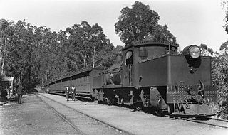
The Mundaring Weir Branch Railway was constructed from Mundaring, Western Australia to the site of the Mundaring Weir, and opened on 1 June 1898.
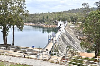
Mundaring Weir is a dam located 39 kilometres (24 mi) from Perth, Western Australia in the Darling Scarp. The dam and reservoir form the boundary between the suburbs of Reservoir and Sawyers Valley. The dam impounds the Helena River.
Swan View is an eastern suburb of Perth, Western Australia. Its local government areas are the City of Swan and the Shire of Mundaring. It is 25 kilometres (16 mi) from Perth in the Perth Hills on the edge of the Darling Scarp, just to the west of the John Forrest National Park, east of Roe Highway and north of the Great Eastern Highway.

Boya is a locality on the Darling Scarp, in the Shire of Mundaring, Western Australia; it is on the south side of Greenmount Hill, and just west of Darlington.
Wooroloo is a town on the outer fringe of the Perth metropolitan region, located off Great Eastern Highway in the eastern part of the Shire of Mundaring. At the 2006 census, Wooroloo had a population of 254.
The Lakes is an outer northeastern locality of Perth, the capital city of Western Australia, located within the Shire of Mundaring. It is located 51 kilometres (32 mi) east of the Perth CBD, at the junction of the Great Eastern Highway and the Great Southern Highway, and is the easternmost suburb within the Metropolitan Region Scheme. At the 2011 census, The Lakes had a population of 45.

Lake Leschenaultia, Western Australia is a former railway dam that is now a recreational lake in the Shire of Mundaring just north of the location of an important railway stopping place on the original Eastern Railway. The dam holds approximately 520 million litres of water.

The Midland Junction railway station was an important junction station on the Eastern Railway of Western Australia until its closure in 1966.

Swan View railway station, Perth was a railway station of significance on the Eastern Railway in Western Australia. In all working timetables during the operation of this line, the station was the point of control for the Swan View Tunnel.

Bellevue railway station was a junction station on the Eastern Railway in the Perth suburb of Bellevue.
The Kep Track is a bicycle, walking and horse track in the Darling Range and further east in Western Australia.

Midland is a suburb in the Perth metropolitan region, as well as the regional centre for the City of Swan local government area that covers the Swan Valley and parts of the Darling Scarp to the east. It is situated at the intersection of Great Eastern Highway and Great Northern Highway. Its eastern boundary is defined by the Roe Highway. Midland is almost always regarded as a suburb of Perth, being only 16 km (10 mi) away from the city centre.

