Armadale is an inner suburb in Melbourne, Victoria, Australia, 7 km south-east of Melbourne's Central Business District, located within the City of Stonnington local government area. Armadale recorded a population of 9,368 at the 2021 census.

The City of Cockburn is a local government area in the southern suburbs of the Western Australian capital city of Perth about 8 kilometres (5 mi) south of Fremantle and about 24 kilometres (15 mi) south of Perth's central business district. The City covers an area of 167.5 square kilometres (64.7 sq mi) and had a population of over 104,000 as at the 2016 Census.
The City of Gosnells is a local government area in the southeastern suburbs of the Western Australian capital city of Perth, located northwest of Armadale and about 20 kilometres (12 mi) southeast of Perth's central business district. The City covers an area of 128 square kilometres (49.42 sq mi), a portion of which is state forest rising into the Darling Scarp to the east, and had a population of approximately 118,000 at the 2016 Census. The largest activity centre in the City is the Central Maddington shopping centre. District centres exist in the Gosnells town centre and Thornlie.

The Town of Victoria Park is a local government area of Western Australia. It covers an area of 17.62 km² in metropolitan Perth, the capital of Western Australia. It had a population of approximately 35,000 as at the 2016 census.

Roleystone is a suburb of Perth, Western Australia in the south eastern corridor.
Brookdale is a suburb of Perth, Western Australia, located within the City of Armadale. Formerly part of the district of Wungong, Brookdale was gazetted in 1997.

The Division of Canning is an Australian Electoral Division in Western Australia.

Jandakot is a southern suburb of Perth, Western Australia, located within the City of Cockburn local government area. It is best known for Jandakot Airport that is situated entirely within the suburb, the airport being "the busiest general aviation airport in Australia in terms of aircraft movements", the sixth-busiest civilian airport in Australia in the fiscal year ending 30 June 2018, and in the 2011 fiscal year even the busiest civilian airport in Australia.

Kelmscott is a southeastern suburb of Perth, Western Australian within the local government area of the City of Armadale. It is 23 kilometres (14 mi) southeast of Perth along the Albany Highway.
Mount Nasura is a suburb of Perth, Western Australia, located within the City of Armadale. The suburb occupies hilly terrain bounded on the north by Brookton Highway and Hill Street (1.6 km), west by Paterson Road (1.1 km), south-west by Canns and Carradine Roads (1.6 km), south by property boundaries on the north side of the Neerigin Brook (0.3 km), and east by Albany Highway (2.7m). With the exception of the Armadale Kelmscott District Memorial Hospital, the suburb is primarily residential.
Camillo is a southeastern suburb of Perth, Western Australia. Its local government area is the City of Armadale and it was part of Kelmscott until 1978. It was named after Camillo Cyrus, the child of Gertrude Seeligson, a local property owner in the area in 1901. Until mid-2008, it was named Westfield, named after a siding on the Jandakot railway line.

Kenwick, Western Australia is a mixed residential, light industrial and semi-rural suburb located in the south-east of Perth, Western Australia, located within the City of Gosnells. A large portion of the suburb is composed of remnant agricultural land organised as smallholdings of several acres, as well as relatively pristine native wetlands, including the Brixton Street Wetlands which are of significant conservation value. It also contains several sites of historical significance relating to its status as one of the early farming communities of the Swan River Colony.
Maddington is a suburb 20 kilometres (12 mi) southeast of the central business district of Perth, the capital of Western Australia, within the City of Gosnells local government area. Maddington is a mixed-use suburb containing major residential, retail and industrial sections as well as some semi-rural areas.

Seville Grove is a suburb of Perth, Western Australia in the City of Armadale.

Victoria Park is an inner suburb of Perth, the capital of the Australian state of Western Australia. It is located on the Swan River south-east of East Perth, and is linked to East Perth and the Perth central business district via The Causeway, which crosses Heirisson Island.

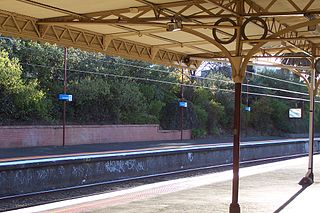
Gosnells is a suburb located within the City of Gosnells. Gosnells is approximately 20 kilometres (12 mi) south-east of the Perth central business district. It contains the Gosnells town centre which includes the Council offices, library and the Gosnells Railway Station.

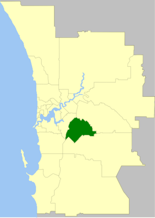
The City of Armadale is a local government area in the southeastern suburbs of the Western Australian capital city of Perth, about 28 kilometres (17.4 mi) southeast of Perth's central business district. The City covers an area of 560 square kilometres (216 sq mi), much of which is state forest rising into the Darling Scarp to the east, and had a population of almost 80,000 as at the 2016 Census. At the 2021 census, the population had risen to 94,184.
Hilbert is a suburb of Perth, Western Australia, located within the City of Armadale. This rural and semi-rural suburb is located on the city's fringe, and in the 2010s began to be subdivided for urban purposes.
Haynes is a suburb of Perth, Western Australia, located within the City of Armadale. This rural and semi-rural suburb is located on the city's fringe, and in the 2010s began to be subdivided for urban purposes.

Treeby is a southern suburb of Perth, Western Australia, located within the City of Cockburn. It is located on the east side of the Kwinana Freeway, close to Cockburn Central.

