Armadale is an inner suburb of Melbourne, Victoria, Australia, 7 km south-east of Melbourne's Central Business District, located within the City of Stonnington local government area. Armadale recorded a population of 9,054 at the 2016 Census.

Armadale is a suburb of Perth within the City of Armadale, located on the south-eastern edge of the Perth metropolitan region. The major junction of the South Western and Albany Highways, which connect Perth with the South West and Great Southern regions of Western Australia respectively, is located within the suburb. It is also the terminus of the Armadale railway line, one of five major railway lines to service Perth.

Roleystone is a suburb of Perth, Western Australia in the south eastern corridor.
The Division of Canning is an Australian Electoral Division in Western Australia.
The Armadale line is a suburban rail service in Western Australia that runs from Perth to Armadale on the South Western Railway. This service is planned to extend to the suburb of Byford over an 8-kilometre-long (5.0 mi) new railway line constructed as part of the Byford Rail Extension project.

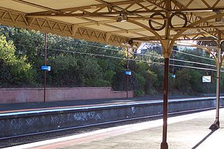
Armadale Station is a railway station on the South Western Railway, 30 kilometres from Perth station serving the suburb of Armadale, Brookdale and Haynes. It is the terminating point for Transperth Armadale line services and a calling point for Transwa Australind services.
Byford is a suburb on the south-eastern edge of Perth, Western Australia, and has its origins in a township that was gazetted under the name "Beenup" in 1906. "Beenup", a corruption of the Aboriginal name associated with nearby Beenyup Brook, was the spelling that had been applied to a railway siding there. The uncorrupted form, "Bienyup" received mention in surveyor Robert Austin's account of an expedition through the area in 1848. In 1920, the name of the township was changed to Byford.
Mount Nasura is a suburb of Perth, Western Australia, located within the City of Armadale. The suburb occupies hilly terrain bounded on the north by the Brookton Highway and Hill Street (1.6 km), west by Paterson Road 1.1 km), south-west by Canns and Carradine Roads (1.6 km), south by property boundaries on the north side of the Neerigin Brook (0.3 km), and east by the Albany Highway (2.7m). With the exception of the Armadale Kelmscott District Memorial Hospital, the suburb is primarily residential.

Atwell is a suburb within the metropolitan area of Perth, Western Australia, situated 21 kilometres (13 mi) south of Perth City, and located in the City of Cockburn local government area.
Success is a southern suburb of Perth, the capital city of Western Australia, located within the City of Cockburn.
Wattle Grove is a suburb of Perth, Western Australia, located within the City of Kalamunda.

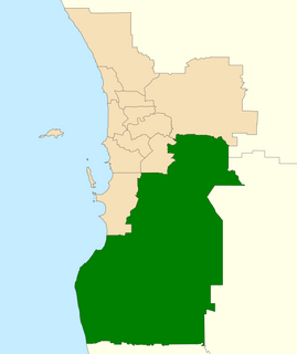
Armadale is a Legislative Assembly electorate in the state of Western Australia. The district is named for the southeastern Perth suburb of Armadale which falls within its borders.

The City of Armadale is a local government area in the southeastern suburbs of the Western Australian capital city of Perth, about 28 kilometres (17.4 mi) southeast of Perth's central business district. The City covers an area of 560 square kilometres (216 sq mi), much of which is state forest rising into the Darling Scarp to the east, and had a population of almost 80,000 as at the 2016 Census.
Cecil Andrews College is a public co-educational high day school, located on Seville Drive in the suburb of Seville Grove near Armadale, part of the metropolitan area of Perth, Western Australia.
Armadale Senior High School is a public co-educational specialist high day school, located on the South Western Highway, in the Perth suburb of Armadale, Western Australia.

The Division of Burt is an Australian electoral division in Perth in the state of Western Australia.
Hilbert is a suburb of Perth, Western Australia, located within the City of Armadale. This rural and semi-rural suburb is located on the city's fringe, and in the 2010s began to be subdivided for urban purposes.
Haynes is a suburb of Perth, Western Australia, located within the City of Armadale. This rural and semi-rural suburb is located on the city's fringe, and in the 2010s began to be subdivided for urban purposes.
Treeby is a suburb of Perth, Western Australia, located within the City of Cockburn. It is located on the east side of the Kwinana Freeway, close to Cockburn Central. It is a southern suburb of Perth, falling within the City of Cockburn local government area.

