Jandakot, Western Australia

Last updated

Jandakot
Perth,  Western Australia
Jandokot Air Traffic Control Back 2006 SMC.jpg
Rear of air traffic control tower, 2006
Jandakot, Western Australia
Coordinates 32°06′09″S115°52′20″E / 32.1023906°S 115.8723359°E / -32.1023906; 115.8723359 (Jandakot)
Population2,533 (SAL 2021) [1]
Postcode(s) 6164
Area16.2 km2 (6.3 sq mi) [2]
Location21 km (13 mi) from Perth
LGA(s) City of Cockburn
State electorate(s) Jandakot
Federal division(s) Fremantle
Suburbs around Jandakot:
North Lake Leeming Canning Vale
Bibra Lake
South Lake
Jandakot Treeby
Cockburn Central
Success
Atwell Banjup
Light aircraft at Jandakot Airport, with the Darling Range in the distance. Aircraft at Jandakot 2006 SMC.jpg
Light aircraft at Jandakot Airport, with the Darling Range in the distance.

Jandakot is a southern suburb of Perth, Western Australia, located within the City of Cockburn local government area. It is best known for Jandakot Airport that is situated entirely within the suburb, the airport being "the busiest general aviation airport in Australia in terms of aircraft movements", [3] :2 the sixth-busiest civilian airport in Australia in the fiscal year ending 30 June 2018, [4] and in the 2011 fiscal year even the busiest civilian airport in Australia. [5]

Contents

History

Jandakot was originally named after Lake Jandakot, which was renamed lake Forrestdale in 1973. Maps of the Swan River Colony produced in the early 1830s show a lake of vast extent situated south west of Kelmscott. The name of the first European to find the lake remains unknown but, in February 1833, Surveyor-General Septimus Roe found the size of the lake had been greatly exaggerated. It became well known as a watering place on the original track between the Canning River and Pinjarra and in 1844 its Aboriginal name was recorded as Jandacot by surveyor J.W. Gregory, brother of Augustus Gregory. During subsequent years, the name was recorded variously as Jandicott, Jandakoot and Jandakott, but the spelling eventually adopted was Jandakot. The Aboriginal meaning of the word is said to be "place of the Whistling Eagle". [6]

Geography

It is bounded to the north by the Roe Highway, Kwinana Freeway to the west, Johnston Road to the east and to the south by Fraser Road, Jandakot Road, Solomon Road and Armadale Road. [7] The northeastern boundary of the suburb is also the municipal boundary of the City of Melville and the eastern boundary is the municipal boundary of the City of Canning.

Jandakot Airport

Jandakot is best known for Jandakot Airport located within it. Jandakot Airport serves pilot testing and domestic plane flights. It is the busiest secondary airport in Australia. A popular feature is the cafe that overlooks the runway. The airport was opened in 1963.

A land development company is keen to redevelop the land occupied by Jandakot Airport in exchange for a new airport more than 70 kilometres (43 mi) from many airport customers. In contrast to the tens of thousands of people now living in its vicinity, there is stiff opposition from the aviation community. [8] The aforementioned land development company received a further setback in 2006 when the Minister for Transport wrote advising them that the airport was to be operated in its current location and in accordance with their lease from the Federal Government. This will include major re-development of the airside facilities including a new parallel 12/30 runway.

Green hydrogen project

In 2018, the Australian Renewable Energy Agency (ARENA), an independent government agency, announced A$1.5 million in funding for Australia's first green hydrogen project, called the ATCO Hydrogen Microgrid, at Jandakot. The project involved a trial by ATCO to produce, store, and use renewable hydrogen to power a microgrid and assess the feasibility of a similar process on a larger scale. [9] After solar energy has been used to separate hydrogen molecules from water, the hydrogen was captured and injected into a micro-grid system at the Clean Energy Innovation Hub (CEIH) at Jandakot. The total project cost was A$3.53m, with A$1.79m coming from ARENA, and the project was completed on 30 November 2019. [10]

Climate

Jandakot gets the comfortable climate of the Perth area with cool, wet winters and hot, dry summers. Summer temperatures can get as high as 45 °C (113 °F), winter weather gets mild temperatures around 15 °C (59 °F). Jandakot holds the record for the lowest temperature in the Perth metro area, of −3.4 °C (25.9 °F), and regularly drops below freezing in winter.

Climate data for Jandakot Airport
MonthJanFebMarAprMayJunJulAugSepOctNovDecYear
Record high °C (°F)45.7
(114.3)
46.6
(115.9)
43.0
(109.4)
39.2
(102.6)
33.4
(92.1)
25.6
(78.1)
25.9
(78.6)
29.4
(84.9)
34.2
(93.6)
37.4
(99.3)
40.3
(104.5)
44.0
(111.2)
46.6
(115.9)
Mean maximum °C (°F)40.3
(104.5)
40.2
(104.4)
38.5
(101.3)
33.5
(92.3)
28.2
(82.8)
23.7
(74.7)
22.3
(72.1)
24.0
(75.2)
26.9
(80.4)
32.2
(90.0)
36.6
(97.9)
39.2
(102.6)
42.0
(107.6)
Mean daily maximum °C (°F)31.3
(88.3)
31.6
(88.9)
29.6
(85.3)
25.8
(78.4)
22.0
(71.6)
19.2
(66.6)
18.0
(64.4)
18.7
(65.7)
20.1
(68.2)
22.9
(73.2)
26.5
(79.7)
29.2
(84.6)
24.6
(76.3)
Mean daily minimum °C (°F)16.8
(62.2)
17.2
(63.0)
15.6
(60.1)
12.5
(54.5)
9.3
(48.7)
7.6
(45.7)
6.9
(44.4)
7.2
(45.0)
8.2
(46.8)
9.8
(49.6)
12.7
(54.9)
14.8
(58.6)
11.6
(52.9)
Mean minimum °C (°F)9.4
(48.9)
10.3
(50.5)
7.2
(45.0)
5.0
(41.0)
2.5
(36.5)
1.0
(33.8)
−0.1
(31.8)
0.8
(33.4)
1.6
(34.9)
3.0
(37.4)
5.8
(42.4)
7.9
(46.2)
−0.9
(30.4)
Record low °C (°F)4.7
(40.5)
6.5
(43.7)
1.6
(34.9)
2.3
(36.1)
−0.6
(30.9)
−3.4
(25.9)
−2.8
(27.0)
−1.4
(29.5)
−1.3
(29.7)
−1.0
(30.2)
0.8
(33.4)
3.2
(37.8)
−3.4
(25.9)
Average rainfall mm (inches)16.1
(0.63)
17.5
(0.69)
16.4
(0.65)
41.1
(1.62)
105.2
(4.14)
152.4
(6.00)
173.1
(6.81)
129.1
(5.08)
84.2
(3.31)
46.0
(1.81)
27.1
(1.07)
10.6
(0.42)
819.6
(32.27)
Average precipitation days2.62.33.87.212.015.617.815.513.59.06.03.4108.7
Average afternoon relative humidity (%) (at 15:00)37363845515758555348433947
Source: Bureau of Meteorology [11] [12] [13]
Temperatures: 1989–2020; Rain data: 1972–2020; Relative humidity: 1990–2010

Related Research Articles

<span class="mw-page-title-main">Perth Airport</span> Airport in Perth, Western Australia

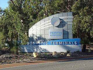
Perth Airport is an international, domestic and general aviation airport serving Perth, the capital city of Western Australia.

<span class="mw-page-title-main">City of Cockburn</span> Local government area in Western Australia

The City of Cockburn is a local government area in the southern suburbs of the Western Australian capital city of Perth about 8 kilometres (5 mi) south of Fremantle and about 24 kilometres (15 mi) south of Perth's central business district. The City covers an area of 167.5 square kilometres (64.7 sq mi) and had a population of over 104,000 as at the 2016 Census.

<span class="mw-page-title-main">Swanbourne, Western Australia</span> Suburb of Perth, Western Australia

Swanbourne is a western coastal suburb of Perth, Western Australia, located within the City of Nedlands. It is an affluent, upper middle class residential area with older Federation style homes, many being renovated. The suburb was established in the late 19th century. New housing estates have been built recently through the redevelopment of areas such as the Swanbourne Senior High School, Swanbourne Primary School and Lakeway Drive-In Cinema sites.

<span class="mw-page-title-main">Leeming, Western Australia</span> Suburb of Perth, Western Australia

Leeming is a southern suburb of Perth, Western Australia. It is divided between the three local government areas of the City of Melville, the City of Cockburn (south) and the City of Canning (north-east). It is located approximately 17 kilometres (11 mi) south of the Perth central business district and 13 kilometres (8.1 mi) east of Fremantle.

<span class="mw-page-title-main">Denham, Western Australia</span> Town in Western Australia

Denham is the administrative town for the Shire of Shark Bay, Western Australia. At the 2016 census, Denham had a population of 754. Located on the western coast of the Peron Peninsula 831 kilometres (516 mi) north of Perth, Denham is the westernmost publicly accessible town in Australia, and is named in honour of Captain Henry Mangles Denham of the Royal Navy, who charted Shark Bay in 1858. Today, Denham survives as the gateway for the tourists who come to see the dolphins at Monkey Mia, which is located 23 kilometres (14 mi) northeast of the town. The town also has an attractive beach and a jetty popular with those interested in fishing and boating.

<span class="mw-page-title-main">Jandakot Airport</span> Airport in Jandakot, Western Australia

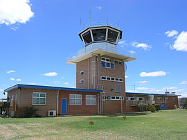
Jandakot Airport is a general aviation (GA) airport located in Jandakot, Western Australia, about 20 kilometres (12 mi) south-southwest of the "general aviation area of the Airport West precinct" at Perth Airport. Jandakot airport opened in 1963. From 1 July 1998, Jandakot Airport Holdings purchased a 50-year lease with a 49-year option to operate and maintain the airport including its conservation areas.

<span class="mw-page-title-main">Bullsbrook, Western Australia</span> Suburb of Perth, Western Australia

Bullsbrook is a northern suburb of Perth, Western Australia in the outer metropolitan area. It is located in the City of Swan. The original Bullsbrook townsite is located slightly west of the current town, on the 17 km mark of the Midland Railway. Bullsbrook is also home to the RAAF Pearce airbase, a major training facility for the Royal Australian Air Force. The suburb is situated on the Great Northern Highway, 25 kilometres north of the Midland Strategic Regional Centre. It is well serviced by several major transport networks including the Great Northern Highway, Railway Parade and the Brand Highway to the north, Chittering Road to the east and Neaves Road to the west. Bullsbrook is also adjacent to the State rail network, providing an opportunity for the development of an intermodal freight transport hub. The site is further strengthened by linkage to the planned Perth-Darwin National Highway via Stock Road.

<span class="mw-page-title-main">Canning Vale, Western Australia</span> Suburb of Perth, Western Australia

Canning Vale is a southern suburb of Perth, 22 km (13.7 mi) from the central business district. Its local government areas are the City of Canning and the City of Gosnells.

<span class="mw-page-title-main">Atwell, Western Australia</span> Suburb of Perth, Western Australia

Atwell is a suburb within the metropolitan area of Perth, Western Australia, situated 21 kilometres (13 mi) south of Perth City, and located in the City of Cockburn local government area.

<span class="mw-page-title-main">Banjup, Western Australia</span> Suburb of Perth, Western Australia

Banjup is a suburb of Perth, Western Australia, located within the City of Cockburn. Its postcode is 6164. It is approximately 25 km (16 mi) south of the Perth central business district.

<span class="mw-page-title-main">Roe Highway</span> Highway in Perth, Western Australia

Roe Highway is a 35-kilometre-long (22 mi) limited-access highway and partial freeway in Perth, Western Australia, linking Kewdale with the city's north-eastern and south-western suburbs. The northern terminus is at Reid Highway and Great Northern Highway in Middle Swan, and the southern terminus is with Murdoch Drive at the Kwinana Freeway interchange in Bibra Lake. Roe Highway, in addition to Reid Highway, form State Route 3, a partial ring road around the outer suburbs of the Perth metropolitan area. Roe Highway also forms part of National Highway 94 from Great Eastern Highway Bypass to Great Eastern Highway, and National Highway 95 from Great Eastern Highway to Great Northern Highway.

<span class="mw-page-title-main">Parafield Airport</span> Airport in Parafield, South Australia

Parafield Airport is on the edge of the residential suburb of Parafield, South Australia, 18 km (11 mi) north of the Adelaide city centre and adjacent to the Mawson Lakes campus of the University of South Australia. It is Adelaide's second airport and the third busiest airport in Australia by aircraft movements. Although owned by the Government of Australia, the airport is leased to and managed independently by Parafield Airport Ltd., a wholly owned subsidiary of Adelaide Airport Limited.

<span class="mw-page-title-main">Perth Airport (suburb)</span> Suburb of Perth, Western Australia

Perth Airport is an eastern suburb of Perth, the capital city of Western Australia. Its local government areas are the City of Belmont, the City of Swan (north) and the City of Kalamunda (east). It is located approximately 12 km east of the central business district. The suburb is the home of Perth Airport, the main international airport of Perth.

<span class="mw-page-title-main">City of Armadale</span> Local government area in Western Australia

The City of Armadale is a local government area in the southeastern suburbs of the Western Australian capital city of Perth, about 28 kilometres (17.4 mi) southeast of Perth's central business district. The City covers an area of 560 square kilometres (216 sq mi), much of which is state forest rising into the Darling Scarp to the east, and had a population of almost 80,000 as at the 2016 Census.

<span class="mw-page-title-main">Rottnest Island Airport</span> Airport on Rottnest Island, Western Australia

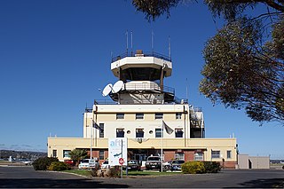
Rottnest Island Airport is a small airport for light aircraft, situated about 800 m (2,600 ft) from the main settlement at Thomson Bay, Rottnest Island and 10 nautical miles northwest of Fremantle. Daily air services operate to the island. In the past these have been from Perth Airport, but in recent years have been mainly from Jandakot.

<span class="mw-page-title-main">Australian Renewable Energy Agency</span> Independent agency of the Australian federal government

The Australian Renewable Energy Agency (ARENA) is an independent agency of the Australian federal government, established in 2012 to manage Australia's renewable energy programs, with the objective of increasing supply and competitiveness of Australian renewable energy sources.

Perth, the capital city of the state of Western Australia, has a Mediterranean climate, with hot, dry summers and mild, wet winters. February is the hottest month of the year, with an average high of 31.6 °C (88.9 °F), and July is the coldest month of the year, with an average low of 7.9 °C (46.2 °F). 77% of rain in Perth falls between May and September. Perth has an average of 8.8 hours of sunshine per day, which equates to around 3,200 hours of annual sunshine, and 138.7 clear days annually, making it the sunniest capital city in Australia.

<span class="mw-page-title-main">Treeby, Western Australia</span> Suburb of Perth, Western Australia

Treeby is a southern suburb of Perth, Western Australia, located within the City of Cockburn. It is located on the east side of the Kwinana Freeway, close to Cockburn Central.

References

  1. Australian Bureau of Statistics (28 June 2022). "Jandakot (suburb and locality)". Australian Census 2021 QuickStats. Retrieved 28 June 2022.  OOjs UI icon edit-ltr-progressive.svg
  2. Australian Bureau of Statistics (27 June 2017). "2016 Community Profiles: Jandakot (State Suburb)". 2016 Census of Population and Housing. Retrieved 3 December 2021. OOjs UI icon edit-ltr-progressive.svg
  3. "Jandakot Airport Master Plan 2014" (PDF). Jandakot Airport Holdings. 17 February 2015. Retrieved 16 March 2019.
  4. "Movements at Australian Airports – 2018 Financial Year Totals" (PDF). Airservices Australia. 25 July 2018. Retrieved 16 March 2019.
  5. "Movements at Australian Airports" (PDF). Airservices Australia. June 2011. Archived from the original (PDF) on 21 March 2016. Retrieved 12 July 2012.
  6. "History of metropolitan suburb names – J". Western Australian Land Information Authority. Archived from the original on 16 March 2022. Retrieved 7 November 2007.
  7. Department of Land Information. StreetSmart Perth Street Directory (54th ed.). West Australian Newspapers Ltd. pp. Maps 462-463. ISBN   978-0-909439-67-5.
  8. "Jandakot Airport Relocation Action group". Archived from the original on 25 December 2006. Retrieved 31 January 2020.
  9. "Green hydrogen innovation hub to be built in WA". Australian Renewable Energy Agency . 3 July 2018. Retrieved 24 March 2024.
  10. "ATCO Hydrogen Microgrid". Australian Renewable Energy Agency . 19 October 2021. Retrieved 23 March 2024.
  11. "Climate statistics for Australian locations – Jandakot Airport". Bureau of Meteorology. Retrieved 16 July 2020.
  12. "Monthly highest temperature – Jandakot Airport". Bureau of Meteorology. Retrieved 16 July 2020.
  13. "Monthly lowest temperature – Jandakot Airport". Bureau of Meteorology. Retrieved 16 July 2020.

Commons-logo.svg Media related to Jandakot, Western Australia at Wikimedia Commons