The name Gosnells may refer to:
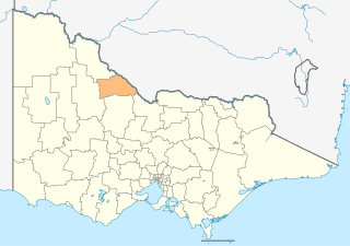
The Shire of Gannawarra is a local government area in Victoria, Australia, located in the northern part of the state. It covers an area of 3,735 square kilometres (1,442 sq mi) and, in June 2018 had a population of 10,547.

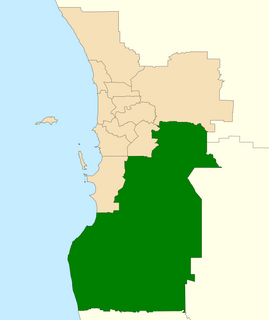
The City of Gosnells is a local government area in the southeastern suburbs of the Western Australian capital city of Perth, located northwest of Armadale and about 20 kilometres (12 mi) southeast of Perth's central business district. The City covers an area of 128 square kilometres (49.42 sq mi), a portion of which is state forest rising into the Darling Scarp to the east, and had a population of approximately 118,000 at the 2016 Census. The largest activity centre in the City is the Central Maddington shopping centre. District centres exist in the Gosnells town centre, Thornlie and Canning Vale.
The Division of Canning is an Australian Electoral Division in Western Australia.

The Division of Hasluck is an electoral division of the Australian House of Representatives, located in Western Australia.

The Division of Tangney is an Australian electoral division in the state of Western Australia. The Division was named after Dame Dorothy Tangney, the first female member of the Australian Senate, and is at present a safe Liberal seat. It is currently held by Ben Morton, a former state director of the Liberal Party.
Huntingdale is a southeastern suburb of Perth, Western Australia. It is part of the City of Gosnells local government area, which suggested the name of the suburb in 1974 as it was used by local developers as a promotional name. It is largely a residential suburb with associated schools and small businesses, mainly existing to service local residents. Homes in the area include a section of older residences constructed mainly in the 1970s, while there was significant new development from the 1990s onward in the southern portion of Huntingdale. There are some remaining pockets of semi-rural land comprising remnants of horticultural and chicken-farming enterprises, but in the early 2000s these were fast being taken over for new residential developments.
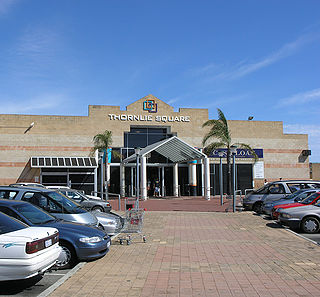
Thornlie is a large residential suburb of Perth, the capital city of Western Australia, located 15 kilometres south-east of the city's central business district. It is a part of the City of Gosnells local government area. The Canning River runs through the northern side of the suburb. Since the 1950s the suburb has developed in approximately five stages; north-east Thornlie (1950s-60s), south Thornlie (1970s-80s), Crestwood (1970s), Castle Glen (1980s) and Forest Lakes.

Canning Vale is a southern suburb of Perth, 16 km (9.9 mi) from the central business district. Its local government areas are the City of Canning and the City of Gosnells.

Beckenham is a suburb of Perth, Western Australia, located within the City of Gosnells.

Kenwick, Western Australia is a mixed residential, light industrial and semi-rural suburb located in the south-east of Perth, Western Australia, located within the City of Gosnells. A large portion of the suburb is composed of remnant agricultural land organized as smallholdings of several acres, as well as relatively pristine native wetlands, including the Brixton Street Wetlands which are of significant conservation value. It also contains several sites of historical significance relating to its status as one of the early farming communities of the Swan River Colony.
Langford is a suburb of Perth, Western Australia, located within the City of Gosnells. Its postcode is 6147.

Maddington is a suburb 20 kilometres (12 mi) southeast of the central business district of Perth, the capital of Western Australia, within the City of Gosnells local government area. Maddington is a mixed-use suburb containing major residential, retail and industrial sections as well as some semi-rural areas.

Southern River is a suburb of Perth, Western Australia, located within the City of Gosnells.

Tonkin Highway is an 81-kilometre-long (50 mi) north–south highway and partial freeway in Perth, Western Australia, linking Perth Airport and Kewdale with the city's north-eastern and south-eastern suburbs. As of April 2020, the northern terminus is at the interchange with Brand Highway and Great Northern Highway in Muchea, and the southern terminus is at Thomas Road in Oakford. It forms the entire length of State Route 4, and connects to several major roads. Besides Brand Highway and Great Northern Highway, it also connects to Reid Highway, Great Eastern Highway, Leach Highway, Roe Highway, and Albany Highway.

Gosnells is a suburb located within the City of Gosnells. Gosnells is approximately 20 kilometres (12 mi) south-east of the Perth central business district. It contains the Gosnells town centre which includes the Council offices, library and the Gosnells Railway Station.
Gosnells was an electoral district of the Legislative Assembly of Western Australia. It was in existence from 1977 to 1989 and from 2008 to 2017. The seat was named after the suburb of Gosnells, and was located in Perth's southeastern suburbs. Gosnells was a safe seat for the Labor Party for most of its existence.

Thornlie is an electoral district of the Legislative Assembly of Western Australia. It is located in Perth's southeastern suburbs, and is named after the suburb of Thornlie.
Southern River College is an independent public co-educational high day school in the City of Gosnells, located on Southern River Road in Gosnells, a suburb of Perth, Western Australia.

The Division of Burt is an Australian electoral division in Perth in the state of Western Australia.
