Mokare

Last updated
Statue of Mokare, Albany, Western Australia Mokare.jpg
Statue of Mokare, Albany, Western Australia
Mokare plaque.jpg
Mokare Statue in Gardens Mokare AHG.jpg
Mokare Statue in Gardens

Mokare (c. 1800 - 26 June 1831) was a Noongar Aboriginal man from the south-west corner of Australia, who was pivotal in aiding European exploration of the area.

Contents

Life

Mokare was from the Minang clan of Noongar people. He had at least two brothers: Mollian (d. 1829), who may have been known as Yallapoli, and Nakina, who like Mokare, became a frequent visitor to the settlement at King George Sound (now Albany). He also had a married sister.

Mokare was probably the same man who met Phillip Parker King when his ship stopped at King George Sound in 1821. [1] "Jack", as King called the man, was a charismatic intermediary between the ship's crew and Noongar people who visited the ship.

In 1826 Mokare met the crew of the French barge Astrolabe who passed the area during their voyage to circumnavigate the world.

In 1827 Major Edmund Lockyer arrived at King George Sound in the brig Amity, to found a penal settlement at King George Sound. Mokare showed Lockyer and other Europeans local walking trails that Noongar people had used and maintained over generations. Many of these became key roads still used in the region. Mokare became a close friend of the surgeon-assistant Isaac Scott Nind, who he frequently visited.

In December 1829 Mokare guided Thomas Braidwood Wilson's overland expedition during which Mount Barker and Mount Lindsay were named, as well as Hay River, Denmark River and Wilson Inlet. Two months later he guided Captain Collet Barker's expedition over the same area.

In 1831 Albany formally became part of the Swan River Colony, and Scotsman Alexander Collie became its first government resident. Mokare built a positive relationship with Collie as he had his predecessors. He sometimes lived with Collie in the latter's house.

As there was no competition between the small European population and the local Minang people for land, women or hunting, intercultural relations at Albany were largely peaceful during Mokare's lifetime. Mokare has also become known as a skilled peacemaker and mediator between Aboriginal and white communities. He was concerned when Governor James Stirling began to take command of the King George Sound settlement in 1830, as he had heard of battles and massacres between European settlers and Aboriginal people, and wished it to be maintained as a separate settlement.

Death and legacy

Mokare fell ill and died at Collie's house on 26 June 1831. Collie described his burial, noting that Noongar people and Europeans assembled at the house and walked to a site selected by Nakina, where the Europeans dug a grave and Mokare was interred with a buka cloak and personal artefacts to Nakina's specifications. [2]

When Collie was dying from tuberculosis in 1835, he asked to be buried alongside Mokare. Their graves were together beneath Albany Town Hall. Four years after Mokare's death, the surveyor John Septimus Roe had the graves exhumed. Collie was re-interred at the newly established Albany Cemetery; however it is not known what happened to Mokare's remains. [1]

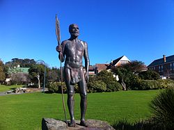
A park consisting of native bushland on the northern side of Mount Melville in Albany was named after Mokare in 1978. [3] A statue was erected in Alison Hartman Gardens on York Street in the centre of Albany in 1997 as part of a reconciliation project. [4]

Alternative spellings

Mokare's name was also spelt as Mokaré, Mokkare, Mawcarrie, Markew or Makkare.

Dumont d'Urville spells his name "Maukorraï" in the second volume of his Voyage pittoresque autour du Monde.

Portrait

Mokaré's portrait was sketched by Louis-Auguste de Sainson in 1826. It appears in colour with his name on the bottom right-hand corner of plate 8 of Dumont d’Urville, Voyage et découvertes de l’Astrolabe..., Atlas, 1833.

Related Research Articles

<span class="mw-page-title-main">Albany, Western Australia</span> City in Western Australia

Albany is a port city in the Great Southern region in the Australian state of Western Australia, 418 kilometres (260 mi) southeast of Perth, the state capital. The city centre is at the northern edge of Princess Royal Harbour, which is a part of King George Sound. The central business district is bounded by Mount Clarence to the east and Mount Melville to the west. The city is in the local government area of the City of Albany. While it is the oldest colonial, although not European, settlement in Western Australia—predating Perth and Fremantle by over two years—it was a semi-exclave of New South Wales for over four years until it was made part of the Swan River Colony.

The human history of Western Australia commenced "over 50,000 years ago and possibly as much as 70,000 years ago" with the arrival of Aboriginal Australians on the northwest coast. The first inhabitants expanded across the east and south of the continent.

<span class="mw-page-title-main">Great Southern (Western Australia)</span> Region of Western Australia

The Great Southern region is one of the nine regions of Western Australia, as defined by the Regional Development Commissions Act 1993, for the purposes of economic development. It is a section of the larger south coast of Western Australia and neighbouring agricultural regions.

<span class="mw-page-title-main">Mount Barker, Western Australia</span> Town in Western Australia

Mount Barker is a town on Albany Highway and the administrative centre of the Shire of Plantagenet in the Great Southern region of Western Australia. At the 2021 census, Mount Barker had a population of 2,855.

<span class="mw-page-title-main">Stirling Range</span> Mountain range in Great Southern region of Western Australia

The Stirling Range or Koikyennuruff is a range of mountains and hills in the Great Southern region of Western Australia, 337 kilometres (209 mi) south-east of Perth. It is over 60 kilometres (37 mi) wide from west to east, stretching from the highway between Mount Barker and Cranbrook eastward past Gnowangerup. The Stirling Range is protected by the Stirling Range National Park, which was gazetted in 1913, and has an area of 1,159 km2 (447 sq mi).

<span class="mw-page-title-main">King George Sound (Western Australia)</span> Large body of water in southern Western Australia

King George Sound is a sound on the south coast of Western Australia. Named King George the Third's Sound in 1791, it was referred to as King George's Sound from 1805. The name "King George Sound" gradually came into use from about 1934, prompted by new Admiralty charts supporting the intention to eliminate the possessive 's' from geographical names.

<span class="mw-page-title-main">Denmark, Western Australia</span> Coastal town in Western Australia

Denmark is a coastal town located on Wilson Inlet in the Great Southern region of Western Australia, 423 kilometres (263 mi) south-south-east of the state capital of Perth. At the 2016 census, Denmark had a population of 2,558; however, the population can be several times the base population during tourist seasons.

<span class="mw-page-title-main">Edmund Lockyer</span> British soldier and explorer of Australia

Edmund Lockyer, was a British soldier and explorer of Australia.

<span class="mw-page-title-main">Whadjuk</span> Noongar people of the Swan Coastal Plain in Western Australia

Whadjuk, alternatively Witjari, are Noongar people of the Western Australian region of the Perth bioregion of the Swan Coastal Plain.

Dr Alexander Collie was a Scottish surgeon and botanist who journeyed to Western Australia in 1829, where he was an explorer and Colonial Surgeon.

<span class="mw-page-title-main">Frankland River (Western Australia)</span> River in Western Australia

The Frankland River is a river in the Great Southern region of Western Australia. The Frankland River is the largest river by volume in the region and the eighth largest in the state. The traditional owners of the area are the Menang Noongar people, who know the river as Kwakoorillup, meaning "place of quokka".

<span class="mw-page-title-main">Hay River (Western Australia)</span> River in Western Australia

The Hay River is a river in the Great Southern region of Western Australia. The traditional owners of the area are the Noongar people, who know the river as Genulup.

<span class="mw-page-title-main">Denmark River</span> River in Western Australia

The Denmark River is located in the Great Southern region of Western Australia. The river rises near Pardelup and meanders in a southerly direction until it flows through Denmark into Wilson Inlet. The traditional owners of the area are the Noongar people, who know the river as Kwoorabup, meaning the place of the western brush wallaby.

This is a timeline of Aboriginal history of Western Australia.

<span class="mw-page-title-main">Kendenup, Western Australia</span> Town in Western Australia

Kendenup is a small town in the Great Southern region of Western Australia, within the Shire of Plantagenet. It is known for its view of Porongurup Range and the Stirling Range. It is 345 kilometres (214 mi) south east of Perth and 22 kilometres (14 mi) north of Mount Barker. The Great Southern Railway passes through the town, being one of the original stations on the line. At the 2006 census, Kendenup had a population of 1,290.

Robert Dale may refer to:

<span class="mw-page-title-main">Mineng</span> Indigenous people of Western Australia

Mineng, also spelled Minang or Minanga or Mirnong, are an indigenous Noongar people of southern Western Australia.

<span class="mw-page-title-main">Old Farm, Strawberry Hill</span> Farm in Albany, Western Australia

The Old Farm, now known as Strawberry Hill/Barmup is located on Strawberry Hill in the suburb of Mira Mar in Albany, Western Australia. It is known as being the first farm in Western Australia.

<span class="mw-page-title-main">History of Albany, Western Australia</span>

The coastline of the Albany area was observed by Europeans for the first time in 1627 by the Dutchman François Thijssen, captain of the ship 't Gulden Zeepaert, who sailed to the east as far as Ceduna in South Australia and back. Captain Thijssen had discovered the south coast of Australia and charted about 1,768 kilometres (1,099 mi) of it between Cape Leeuwin and the Nuyts Archipelago.

References

  1. 1 2 Green, Neville (2005). "Mokare (1800–1831)". Australian Dictionary of Biography.
  2. Dale, R. 1834 Descriptive Account of the Panoramic View &c. of King George's Sound and the Adjacent Country p. 9
  3. "Mount Melville". InHerit. Heritage Council of Western Australia. 8 February 2015. Retrieved 23 April 2016.
  4. "Mokare - Man of Peace". Monument Australia. Retrieved 23 April 2016.