Alison Hartman Gardens

Last updated

Alison Hartman Garden looking south west AHG2.jpg
Alison Hartman Garden looking south west
Mokare Statue in Gardens Mokare AHG.jpg
Mokare Statue in Gardens

Alison Hartman Garden, often referred to as Mokare Park, is a park on York Street in Albany in the Great Southern region of Western Australia.

York Street, Albany street in the centre of Albany, Western Australia

York Street is the main street in the centre of Albany, Western Australia. It runs south from a junction with Albany Highway, Lockyer Avenue and Middleton Road downhill towards Princess Royal Drive and the Anzac Peace Park at the foot of the hill adjacent to Princess Royal Harbour.

Albany, Western Australia City in Western Australia

Albany is a port city in the Great Southern region of Western Australia, 418 km SE of Perth, the state capital. Albany is the oldest colonial settlement in Western Australia, predating Perth and Fremantle by over two years.

Great Southern (Western Australia) region of Western Australia

The Great Southern Region is one of the nine regions of Western Australia, as defined by the Regional Development Commissions Act 1993, for the purposes of economic development. It is a section of the larger South Coast of Western Australia and neighbouring agricultural regions.

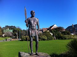
The park, located near the centre of Albany, [1] contains numerous sculptures including the statue of Mokare. [2]

Mokare indigenous Australian explorer

Mokare was a Noongar man, an Aboriginal man from the south-west corner of Australia who was pivotal in aiding European exploration of the area. Mokare had two known brothers: Mollian, who may have been known as Yallapoli, and Nakina, who with Mokare, was a frequent visitor to the Albany settlement, staying with the government resident, Dr Alexander Collie. He also was recorded as having a married sister.

The area is situated adjacent to the Albany Public Library and the Albany Town Square. It often hosts local markets. [3] The area was once the vegetable gardens behind the old state school, which is now the Albany District Education Centre. The gardens are named after a long-serving teacher at Albany State School, Alison Edith Hartman (1906-1978). [4] She was the daughter of John Hartman, who built Albany War Memorial, [5] and she was the Principal of Albany Primary School from 1935 to 1967. [6]

The gardens contain two large Norfolk Island Pine trees and a Quercus robur tree [7] that date back to the 1890s along the southern edge. The pines are decorated every Christmas season. The statue of Mokare was erected in 1977 as a memorial to the Noongar man who helped he early settlers maintain a peaceful coexistence with the traditional owners. A series of community sculptures were set around a granite outcrop in the gardens in 1989. These include large, century-old timbers are from the original own Jetty that symbolise Jetty, ships loading cranes and other agricultural machinery to acknowledge the importance of shipping and agriculture in the early development of the town. A Peace Pole, featuring the message May Peace prevail on Earth, at the rear of the gardens was erected in 2011 as part of the Harmony Day celebrations. [8]

<i>Quercus robur</i> species of plant

Quercus robur, commonly known as common oak, pedunculate oak, European oak or English oak, is a species of flowering plant in the beech and oak family, Fagaceae. It is native to most of Europe west of the Caucasus. The tree is widely cultivated in temperate regions and has escaped into the wild in scattered parts of China and North America.

Noongar an Indigenous Australian people who live in the south-west corner of Western Australia, from Geraldton on the west coast to Esperance on the south coast

The Noongar are a constellation of peoples of Indigenous Australian descent who live in the south-west corner of Western Australia, from Geraldton on the west coast to Esperance on the south coast. Noongar country is now understood as referring to the land occupied by 14 different groups: Amangu, Ballardong, Yued, Kaneang, Koreng, Mineng, Njakinjaki, Njunga, Pibelmen, Pindjarup, Wardandi, Whadjuk, Wiilman and Wudjari.

Menang is a traditional dance of the Tikar or the Semi-Bantu group of people from the Adamawa mountains of Cameroon.

See also

List of places on the State Register of Heritage Places in the City of Albany

Related Research Articles

Victoria Square, Adelaide square in Adelaide, South Australia, Australia

Victoria Square, also known as Tarntanyangga or Tarndanyangga, is a public square in the South Australian capital of Adelaide. The area was named "Victoria Square" by the Street Naming Committee on 23 May 1837, after Princess Victoria, then heir presumptive of the British throne. Less than a month later the King died and Victoria became Queen. The Kaurna people know the area as Tarndanyangga, "The Dreaming Place of the Red Kangaroo". In line with the Adelaide City Council's recognition of Kaurna country, the area is officially referred to as Victoria Square/Tarndanyangga. The square was upgraded in 2014, new lighting was added and the fountain was moved from the northern end to the southern tip of the square. During the Christmas period, it is traditional for a 24.5 m high Christmas tree to be erected in the northern part of the square.

Queens Gardens, Brisbane

Queens Gardens is a heritage-listed park located on a city block between George Street, Elizabeth Street and William Street in the Brisbane CBD, City of Brisbane, Queensland, Australia. It was built from c. 1905 to 1990s. It is also known as Executive Gardens and St Johns Church Reserve. It was added to the Queensland Heritage Register on 21 October 1992.

City of Albany Local government area in Western Australia

The City of Albany is a local government area in the Great Southern region of Western Australia, about 410 kilometres (255 mi) south-southeast of Perth, the capital of Western Australia. It covers an area of 4,312.3 square kilometres (1,665 sq mi), including the Greater Albany metropolitan area and the Port of Albany, as well as the surrounding agricultural district and some national parks. The City of Albany had a population of over 36,000 at the 2016 census.

Centennial Park, Western Australia Suburb of Albany, Western Australia

Centennial Park is an inner suburb of Albany, Western Australia, immediately north of the CBD within the local government area of the City of Albany. It contains a light industrial area and numerous sporting facilities which serve the entire Albany catchment area.

Middleton Beach, Western Australia Suburb of Albany, Western Australia

Middleton Beach is a coastal suburb of Albany, Western Australia, located within the City of Albany approximately 4 kilometres (2.5 mi) east of the city centre. The traditional owners, the Noongar peoples, know the place as Binalup meaning the place of first light since the sun rises over the waters in the morning. The main road between the city and the locality is via Middleton Road. It is home to a caravan park and numerous holiday units which provide accommodation for visitors to the Albany region.

Mount Clarence, Western Australia Suburb of Albany, Western Australia

Mount Clarence is an inner suburb of Albany, Western Australia, between the Albany city centre and Middleton Beach. Its local government area is the City of Albany, and over three-quarters of its land area is either parkland or forest, including Albany's Heritage Park. Mount Clarence was gazetted as a suburb in 1979.

Kalgan River Long that goes to

The Kalgan River is a river in the Great Southern region of Western Australia.

Mira Mar, Western Australia Suburb of Albany, Western Australia

Mira Mar is a northeastern suburb of Albany, Western Australia, between the Albany city centre and Spencer Park in the local government area of the City of Albany.

Albany Town Hall (Western Australia) town hall in Albany, Western Australia

Albany Town Hall is a public building on York Street in Albany in the Great Southern region of Western Australia. It was the first civic building constructed in the town.

ANZAC Peace Park

ANZAC Peace Park is a park in Albany in the Great Southern region of Western Australia. It is located at the foot of the hill where York Street meets Princess Royal Drive.

Stirling Terrace, Albany street in Albany, Western Australia

Stirling Terrace, Albany is a street in the centre of Albany, Western Australia adjoining York Street.

Royal George Hotel, Albany

The Royal George Hotel is a heritage listed building that operates as a hotel in Albany in the Great Southern region of Western Australia.

Ellen Cove Jetty

Ellen Cove Jetty also known as Middleton Beach Jetty is a jetty found at the southern end of Middleton Beach in King George Sound in Albany in the Great Southern region of Western Australia.

Albany Masonic Hall masonic temple in Albany, Western Australia

The Albany Masonic Hall, also known as Plantagenet Lodge, is a heritage listed building located at 58-60 Spencer Street, on the corner of Earl Street, on the south western slopes of Mount Clarence in Albany in the Great Southern region of Western Australia.

<i>Pikachu</i> (sculpture) sculpture in New Orleans, USA

Pikachu, also known as the Pokemonument, was an outdoor 2016 fiberglass sculpture depicting the Pokémon species of the same name by an unknown artist, installed in Lower Garden District, New Orleans, in the U.S. state of Louisiana.

Eyre Park

The Eyre Park is a park in Middleton Beach in Albany in the Great Southern region of Western Australia.

<i>Peter Pan</i> statue sculpture by George Frampton in Kensington Gardens, London

The Peter Pan statue is a bronze sculpture of J. M. Barrie's character Peter Pan. It was commissioned by Barrie and made by Sir George Frampton. The original statue is displayed in Kensington Gardens in London, to the west of The Long Water, close to Barrie's former home on Bayswater Road. Barrie's stories were inspired in part by the gardens: the statue is located at the place where Peter Pan lands in Barrie's book The Little White Bird after flying out of his nursery. Six other casts made by the original artist have been erected in other locations around the world.

References

  1. "Alison Hartman Garden". Albany Gateway. Retrieved 31 July 2016.
  2. "State Finalists". Keep Australia Beautiful . Retrieved 31 July 2016.
  3. "Special Council Meeting" (PDF). City of Albany. 28 April 2014. Retrieved 31 July 2016.
  4. "Hartman, (Edith) Alison". Albany Public Library. 4 September 1979. Retrieved 31 July 2016.
  5. Malcolm Traill (2013). "York Street: The story of a town's main street" (PDF). Western Australian Museum . Retrieved 31 July 2016.
  6. "Alison Hartman Gardens". Virtual Tourist. 1 June 2016. Retrieved 31 July 2016.
  7. "Alison Hartman Gardens & Significant Trees". InHerit. Heritage Council of Western Australia. 27 February 2016. Retrieved 2 August 2016.
  8. "Alison Hartman Gardens". Visit Albany. 2 September 2015. Retrieved 31 July 2016.

Coordinates: 35°01′22″S117°52′58″E / 35.02271°S 117.8829°E / -35.02271; 117.8829

Geographic coordinate system Coordinate system

A geographic coordinate system is a coordinate system that enables every location on Earth to be specified by a set of numbers, letters or symbols. The coordinates are often chosen such that one of the numbers represents a vertical position and two or three of the numbers represent a horizontal position; alternatively, a geographic position may be expressed in a combined three-dimensional Cartesian vector. A common choice of coordinates is latitude, longitude and elevation. To specify a location on a plane requires a map projection.