↑ Conti, L; Wilke, S; Koska, L; Water Authority of Western Australia. Headworks and Treatment Region; Water Authority of Western Australia. Scientific Services Branch (1991), Lower Helena catchment water quality study, Headworks & Treatment Region [and] Scientific Services Branch, Water Authority of Western Australia, retrieved 9 July 2017
↑ Western Australian Planning Commission; Western Australia. Water and Rivers Commission (2003), Middle Helena catchment area land use and water management strategy: published by the Western Australian Planning Commission for public comment, August 2003, Western Australian Planning Commission, ISBN978-0-7309-9393-3
↑ Western Australian Planning Commission (2010), Middle Helena catchment area land use and water management strategy, Western Australian Planning Commission, ISBN978-0-7309-9976-8
The Darling Scarp, also referred to as the Darling Range or Darling Ranges, is a low escarpment running north–south to the east of the Swan Coastal Plain and Perth, Western Australia. The escarpment extends generally north of Bindoon, to the south of Pemberton. The adjacent Darling Plateau goes easterly to include Mount Bakewell near York and Mount Saddleback near Boddington. It was named after the Governor of New South Wales, Lieutenant-General Ralph Darling.
The River Derwent is a river located in Tasmania, Australia. It is also known by the palawa kani name timtumili minanya. The river rises in the state's Central Highlands at Lake St Clair, and descends more than 700 metres (2,300 ft) over a distance of more than 200 kilometres (120 mi), flowing through Hobart, the state's capital city, before emptying into Storm Bay and flowing into the Tasman Sea. The banks of the Derwent were once covered by forests and occupied by Aboriginal Tasmanians. European settlers farmed the area and during the 20th century many dams were built on its tributaries for the generation of hydro-electricity.
The south-west corner drainage region of Western Australia is one of only two temperate and relatively fertile parts of mainland Australia. It covers about 140,000 square kilometres (54,000 sq mi), or a little less than 2% of the continent. For comparison, this is about the same size as North Carolina or a little larger than England.
Warragamba Dam is a heritage-listed dam in the outer South Western Sydney suburb of Warragamba, Wollondilly Shire in New South Wales, Australia. It is a concrete gravity dam, which creates Lake Burragorang, the primary reservoir for water supply for the city of Sydney. The dam wall is located approximately 65 kilometres (40 mi) W of Sydney central business district, 4½ km SW of the town of Wallacia, and 1 km NW of the village of Warragamba.
The Margaret River is a river in southwest Western Australia. In a small catchment, it is the eponym of the town and tourist region of Margaret River.
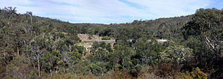
The Helena River is a tributary of the Swan River in Western Australia. The river rises in country east of Mount Dale and flows north-west to Mundaring Weir, where it is dammed. It then flows west until it reaches the Darling Scarp.
Orange Grove is a suburb of Perth, Western Australia in the City of Gosnells.
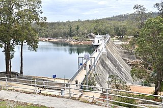
Mundaring Weir is a concrete gravity dam located 39 kilometres (24 mi) from Perth, Western Australia in the Darling Scarp. The dam and reservoir form the boundary between the suburbs of Reservoir and Sawyers Valley. The dam impounds the Helena River.
The Woronora River is a perennial river of the Sydney Basin, located in the Sutherland Shire local government area of Greater Metropolitan Sydney, approximately 22 kilometres (14 mi) south of the Sydney central business district, in New South Wales, Australia.
The Prospect Reservoir is a heritage-listed 50,200-megalitre potable water supply and storage reservoir created by the Prospect Dam, across the Prospect Creek located in the Western Sydney suburb of Prospect, in New South Wales, Australia. The eastern bounds of the reservoir are a recreational area and the western periphery are within the bounds of Western Sydney Parklands. It was added to the New South Wales State Heritage Register on 18 November 1999.
The Tungatinah Power Station is a conventional hydroelectric power station located in the Central Highlands region of Tasmania, Australia. The power station is situated on the Upper River Derwent catchment and is owned and operated by Hydro Tasmania.
Toodyay Road is a mostly 2-lane undivided single carriageway in Western Australia, running from the north-eastern Perth suburb of Middle Swan, through Gidgegannup and Bailup, to the Wheatbelt town of Toodyay. It is signposted as State Route 50.
Bickley Pumpback Dam, known also as the Lower Bickley Brook reservoir, is located in Perth, Western Australia.
Araluen Pumpback Dam is a minor dam on the Canning River. Water stored in the dam can be pumped back into Canning Dam where the water is treated and distributed through the metropolitan trunk main distribution system.
The King River is a river in the Great Southern region of Western Australia.
Deep River is a river located in the Great Southern region of Western Australia.
Seqwater is a statutory authority of the Government of Queensland that provides bulk water storage, transport and treatment, water grid management and planning, catchment management and flood mitigation services to the South East Queensland region of Australia. Seqwater also provides irrigation services to about 1,200 rural customers in the region that are not connected to the grid and provides recreation facilities.
Angove River or Angove Creek is a river located in the Great Southern region of Western Australia most of the river is found within Two Peoples Bay Nature Reserve.
As Australia's supply of freshwater is increasingly vulnerable to droughts, possibly as a result of climate change, there is an emphasis on water conservation and various regions have imposed restrictions on the use of water.
Yenyenning Lake, also often spelt Yenyening Lakes, and associated lakes are in the upper Avon River catchment area in Western Australia, and the source of the Avon and Swan River systems.
This page is based on this Wikipedia article Text is available under the CC BY-SA 4.0 license; additional terms may apply. Images, videos and audio are available under their respective licenses.