
The Wheatbelt is one of nine regions of Western Australia defined as administrative areas for the state's regional development, and a vernacular term for the area converted to agriculture during colonisation. It partially surrounds the Perth metropolitan area, extending north from Perth to the Mid West region, and east to the Goldfields–Esperance region. It is bordered to the south by the South West and Great Southern regions, and to the west by the Indian Ocean, the Perth metropolitan area, and the Peel region. Altogether, it has an area of 154,862 square kilometres (59,793 sq mi).

Wagin is a town and shire in the Wheatbelt region of Western Australia, approximately 225 km (139.81 mi) south-east of Perth on the Great Southern Highway between Narrogin and Katanning. It is also on State Route 107. The main industries are wheat and sheep farming.

Narrogin is a town in the Wheatbelt region of Western Australia, 192 kilometres (119 mi) southeast of Perth on the Great Southern Highway between Pingelly and Wagin. In the age of steam engines, Narrogin was one of the largest railway operation hubs in the southern part of Western Australia.

Australian Railroad Group (ARG) was an Australian rail freight operator. It began operations in Western Australia on 17 December 2000 following its purchase of the Westrail freight business. It was purchased by QR National in June 2006. The main commodities hauled by ARG included grain, mineral sands, alumina, bauxite, coal, woodchips, quartz, nickel and iron ore around Western Australia. In June 2011, it ceased trading as a separate brand, and became part of QR National.

Brunswick Junction is a town in the South West of Western Australia, situated along the South Western Highway between Harvey and Bunbury. It had a population of 772 people at the 2016 census, down from 797 at the 2006 census.

Western Australian Government Railways (WAGR) was the operator of railway services in the state of Western Australia between October 1890 and June 2003. Owned by the state government, it was renamed a number of times to reflect extra responsibility for tram and ferry operations that it assumed and later relinquished. Westrail was the trading name of WAGR from September 1975 until December 2000, when the WAGR's freight division and the Westrail name and logo were privatised. Its freight operations were privatised in December 2000 with the remaining passenger operations transferred to the Public Transport Authority in July 2003.
Narngulu is an outer suburb of the Western Australian city of Geraldton, and is for the most part an industrial area.

The Great Southern Railway was a railway company that operated from Beverley to Albany in Western Australia between 1886 and 1896. In 1896 the Western Australian Government Railways took over the company, and kept the name for the route.
Yilliminning is a small town located in the southern Wheatbelt region of Western Australia, 212 kilometres (132 mi) southeast of the state capital, Perth and 23 kilometres (14 mi) east of Narrogin. At the 2006 census, Yilliminning had a population of 337.

Railways in Western Australia were developed in the 19th century both by the Government of Western Australia and a number of private companies. Today passenger rail services are controlled by the Public Transport Authority through Transperth, which operates public transport in Perth, and Transwa, which operates country passenger services. Journey Beyond operates the Indian Pacific.

Duranillin is a small town located in the Wheatbelt region of Western Australia, 24 kilometres (15 mi) south of Darkan near the junction of the Arthur and Beaufort rivers.

The South Western Railway, also known as the South West Main Line, is the main railway route between Perth and Bunbury in Western Australia.

Merredin railway station is located on the Eastern Goldfields Railway in Western Australia. It is in the town of Merredin.

The wheatbelt railway lines of Western Australia were, in most cases, a network of railway lines in Western Australia that primarily served the Wheatbelt region.

Western Australian Government Railways railway system during its peak operational time in the 1930s to 1950s was a large system of over 6,400 kilometres (4,000 mi) of railway line.

Mumballup is a locality in the South West region of Western Australia, situated between Collie and Boyup Brook, 221 kilometres (137 mi) south of Perth. The town is in the Shire of Donnybrook-Balingup.

The Donnybrook–Katanning railway was a railway line in the South West and Great Southern regions of Western Australia, between Donnybrook and Katanning.
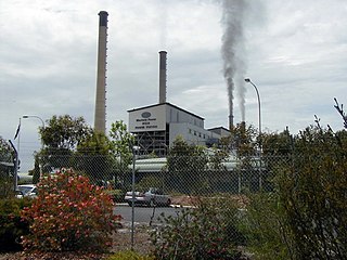
Muja is a rural town and locality of the Shire of Collie in the South West region of Western Australia. The western part of the locality is dominated by coal mining and the coal-fired Muja Power Station while the eastern part is rural and forested.

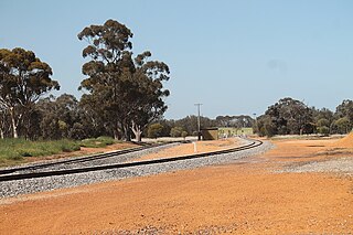
The Wagin to Newdegate railway line is a railway line in the Wheatbelt region of Western Australia, connecting Wagin via Lake Grace to Newdegate, where the line terminates. The line is 180 kilometres (110 mi) long. At Lake Grace, a 94-kilometre (58 mi) branch line to Hyden exists, while, at Wagin, the railway line connects to the Great Southern Railway. Formerly, at Wagin, it also connected to the now inactive railway line to Bowelling.
The Wagin to Bowelling railway line was a railway line in the Wheatbelt region of Western Australia, connecting Wagin via Bokal to Bowelling. The line was 102 kilometres (63 mi) long. At Wagin, the railway line connects to the Great Southern Railway while, at Bowelling, it connected to the Brunswick Junction to Narrogin railway line.


