Laverton, originally known as British Flag, is a town in the Goldfields region of Western Australia, and the centre of administration for the Shire of Laverton. The town of Laverton is located at the western edge of the Great Victoria Desert, 957 kilometres (595 mi) north-northeast of the state capital, Perth, and 124 kilometres (77 mi) east-northeast of the town of Leonora, with an elevation of 461 metres (1,512 ft).

Leonora is a town in the Goldfields-Esperance region of Western Australia, located 833 kilometres (518 mi) northeast of the state capital, Perth, and 237 kilometres (147 mi) north of the city of Kalgoorlie.

Westonia is a small town located in the eastern Wheatbelt region of Western Australia, 10 kilometres (6 mi) north of the Great Eastern Highway. It is the main town in the Shire of Westonia.

Meekatharra is a town in the Mid West region of Western Australia. Meekatharra is a Yamatji word meaning "place of little water". At the 2016 census, Meekatharra had a population of 708, with 34.0% being of Aboriginal descent.

Mount Magnet is a town in the Mid West region of Western Australia. It is one of the region's original gold mining towns, and the longest surviving gold mining settlement in the state. The prominent hill that is adjacent to the current townsite was called West Mount Magnet in 1854 by explorer Robert Austin, having named a smaller hill 64 km away, East Mount Magnet. Both hills had an extremely high iron content which affected the readings of his compass. West Mount Magnet had its Aboriginal name reinstated by the Surveyor General in 1972, "Warramboo," meaning campfire camping place. The magnetic variation at Mount Magnet is zero: magnetic north equals true north.

The Shire of Yilgarn is a local government area in the eastern Wheatbelt region of Western Australia about 400 kilometres (250 mi) east of Perth, the state capital. The Shire covers an area of 30,720 square kilometres (11,860 sq mi) and its seat of government is the town of Southern Cross. The main industries within the Shire are mining and farming.
Marvel Loch is a small townsite of fewer than 100 people, 401 kilometres (249 mi) east of Perth, Western Australia. It is located 32 kilometres (20 mi) south west of Southern Cross, along the Perth to Kalgoorlie Great Eastern Highway. The town is located in the Shire of Yilgarn.
Yellowdine is a town located 402 kilometres (250 mi) east of Perth, Western Australia on the Great Eastern Highway. The townsite is in the Goldfields-Esperance region, situated in the Shire of Yilgarn.

Menzies is a town in the Goldfields-Esperance region of Western Australia, 728 kilometres (452 mi) east-northeast of the state capital, Perth, and 133 kilometres (83 mi) north-northwest of the city of Kalgoorlie. At the 2016 census, Menzies had a population of 108. Aboriginal people have lived in this area since time immemorial, and the local group are the Kaburn Bardu.
Mount Mulligan is a former mining town and now a rural locality in the Shire of Mareeba, Queensland, Australia. In the 2021 census, the locality of Mount Mulligan had "no people or a very low population".

The Shire of Westonia is a local government area in the eastern Wheatbelt region of Western Australia, about 310 kilometres (193 mi) east of Perth, the state capital. Its seat of government is the small town of Westonia.

Sandstone is a small town in the Mid West region of Western Australia 157 kilometres (98 mi) east of Mount Magnet and 661 kilometres (411 mi) north of the state capital, Perth. At the 2016 census, Sandstone and the surrounding Shire of Sandstone had a population of 89 people, including 19 families. Sandstone is the administrative centre and only town in the Shire of Sandstone local government area.
Agnew is a ghost town in the Goldfields-Esperance region of Western Australia 982 kilometres (610 mi) north-east of Perth; the closest populated town is Leinster.

Leadville is a town in New South Wales, Australia. The town is located in the Warrumbungle Shire local government area, 376 kilometres (234 mi) north west of the state capital, Sydney. At the 2016 census, Leadville and the surrounding area had a population of 169.
Bulong is an abandoned town in Western Australia located 580 kilometres (360 mi) east of Perth in the Goldfields-Esperance region of Western Australia.
Mount Morgans, known as Mount Morgan until 1899, is an abandoned town in Western Australia 900 kilometres (559 mi) northeast of Perth and 40 kilometres (25 mi) southwest of Laverton on the original Malcolm-Laverton Road, in the Goldfields-Esperance region of Western Australia.
Mount Margaret was an abandoned town located 900 kilometres (559 mi) northeast of Perth and 31 kilometres (19 mi) southwest of Laverton in the Goldfields-Esperance region of Western Australia.

Beria is an abandoned town in the Goldfields-Esperance region of Western Australia, located 8 kilometres (5 mi) north of Laverton on the Laverton-Leonora Road.
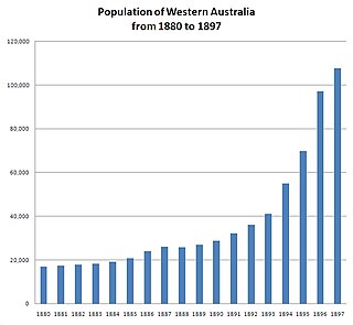
In the latter part of the nineteenth century, discoveries of gold at a number of locations in Western Australia caused large influxes of prospectors from overseas and interstate, and classic gold rushes. Significant finds included:
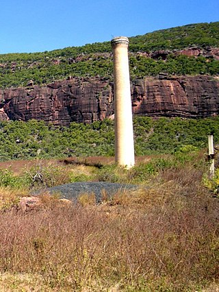
Mulwarrie is an abandoned town in the North Coolgardie Goldfield of the Goldfields-Esperance region of Western Australia, 125 km northwest of Kalgoorlie, between Davyhurst and Mulline.

