Related Research Articles

Charles Yelverton O'Connor,, was an Irish engineer who is best known for his work in Western Australia, especially the construction of Fremantle Harbour, thought to be impossible, and the Goldfields Water Supply Scheme.

Southern Cross is a town in Western Australia, 371 kilometres east of state capital Perth on the Great Eastern Highway. It was founded in 1888 after gold prospectors Richard Greaves and Ted Paine during their October 1887 expedition successfully found gold, and gazetted in 1890. It is the major town and administrative centre of the Shire of Yilgarn. At the 2016 census, Southern Cross had a population of 680.

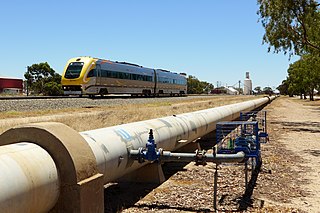
Merredin is a town in Western Australia, located in the central Wheatbelt roughly midway between Perth and Kalgoorlie, on Route 94, Great Eastern Highway. It is located on the route of the Goldfields Water Supply Scheme, and as a result is also on the Golden Pipeline Heritage Trail.
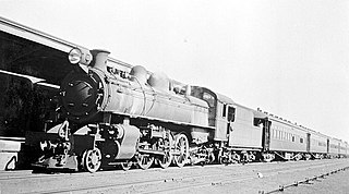
The Eastern Goldfields Railway, historically also referred to as the Fremantle-Kalgoorlie Railway, was built in the 1890s by the Western Australian Government Railways to connect Perth with the Eastern Goldfields at Coolgardie and Kalgoorlie.
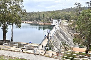
Mundaring Weir is a concrete gravity dam located 39 kilometres (24 mi) from Perth, Western Australia in the Darling Scarp. The dam and reservoir form the boundary between the suburbs of Reservoir and Sawyers Valley. The dam impounds the Helena River.

Menzies is a town in the Goldfields-Esperance region of Western Australia, 728 kilometres (452 mi) east-northeast of the state capital, Perth, and 133 kilometres (83 mi) north-northwest of the city of Kalgoorlie. At the 2016 census, Menzies had a population of 108. Aboriginal people have lived in this area since time immemorial, and the local group are the Kaburn Bardu.

The Goldfields Water Supply Scheme is a pipeline and dam project that delivers potable water from Mundaring Weir in Perth to communities in Western Australia's Eastern Goldfields, particularly Coolgardie and Kalgoorlie. The project was commissioned in 1896 and completed in 1903.
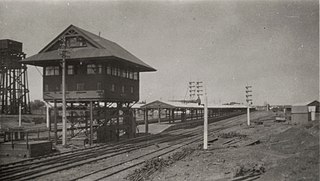
Kalgoorlie railway station is the easternmost attended station in Western Australia, located at the eastern terminus of the Eastern Goldfields Railway. It serves the city of Kalgoorlie. Beyond Kalgoorlie, the line continues east as the Trans-Australian Railway.

The network of railway lines in Western Australia associated with the timber and firewood industries is as old as the mainline railway system of the former Western Australian Government Railways system.
The Esperance Branch Railway is a railway from Kalgoorlie to the port of Esperance in Western Australia.
Bulong is an abandoned town in Western Australia located 580 kilometres (360 mi) east of Perth in the Goldfields-Esperance region of Western Australia.
Comet Vale is an abandoned town in Western Australia located in the Goldfield region of Western Australia located between Kalgoorlie and Laverton on the Goldfields Highway. It is within the Shire of Menzies.
Malcolm is an abandoned town located between Leonora and Laverton in the Shire of Leonora in the Goldfields-Esperance region of Western Australia. It was also known as Mount Malcolm. Gold was discovered in the area in 1895, and in 1896 the local provisional committee lobbied the government to perform a survey and declare a townsite. The town had six stores, three hotels and two bakeries at this time. The townsite was gazetted in 1897. In 1900 the town was incorporated and had kerosene street lights and a swimming pool. In 1903 over 200 buildings were located in town and the population had reached 450. By 1904 the town had a population of 400 along with six hotels and a brewery.
Railway dams and reservoirs were used to supply water to an extensive railway system that ventured into low rainfall, and poor water quality areas of the inner regions of Western Australia in the 1890s.
The Kalgoorlie was a railway passenger service operated by the Western Australian Government Railways between November 1962 and November 1971.
Ghouli, Western Australia was the location of Number 6 Pumping station on the Goldfields Water Supply Scheme, and is the location of the current pumping station number 14 on the pipeline.
Gilgai, Western Australia was the location of Number 7 Pumping station on the Goldfields Water Supply Scheme
Dedari, Western Australia was the location of Number 8 Pumping station on the Goldfields Water Supply Scheme

Boulder railway station was part of the Boulder loopline, a railway that commenced at the Kalgoorlie railway station and travelled south for the purpose of transporting workers to the mines on the Golden Mile in Kalgoorlie-Boulder in Western Australia.
The Kalgoorlie to Leonora railway line or Leonora branch line is a railway line in the Goldfields–Esperance region of Western Australia, connecting Kalgoorlie via Malcolm to Leonora. The line is 259 kilometres (161 mi) long and formerly also had a 103-kilometre (64 mi) branch line from Malcolm to Laverton. At Kalgoorlie, the railway line connects to the Eastern Goldfields Railway, where it also connects to the Esperance Branch Railway.
References
- ↑ No.5 Pumping Station Yerbillon, 13/11/02, 1900, retrieved 3 March 2016
- ↑ "No Title". Kalgoorlie Western Argus . Vol. VIII and XIII, , no. 671. Western Australia. 17 September 1907. p. 26. Retrieved 14 August 2024– via National Library of Australia.
{{cite news}}: CS1 maint: extra punctuation (link) - ↑ Baldwin engine off the line at Yerbillon, 1900, retrieved 3 March 2016
- ↑ "Railway Collision". The Northam Advertiser . Vol. IX, no. 760. Western Australia. 18 June 1902. p. 3. Retrieved 11 March 2019– via National Library of Australia.
- ↑ "Forty Years Ago". Kalgoorlie Miner . Vol. 48, , no. 12, 576. Western Australia. 26 October 1942. p. 2. Retrieved 14 August 2024– via National Library of Australia.
{{cite news}}: CS1 maint: extra punctuation (link) - ↑ Lorman, Edna; Hutchinson, Joan (2004), Yerbillon: recollections of childhood years at Yerbillon, the number 5 pumping station of the Goldfields water supply system in Western Australia during the early years of the 20th century, Perth, W.A.: J. Hutchinson, retrieved 3 March 2016
- ↑ Blundell, Oswald; Hartley, Richard G. (2002), Interview with Oswald Blundell (sound recording), Goldfields and Agricultural Water Supply History Project, Water Corporation of Western Australia, retrieved 18 October 2016
- ↑ Geary, Annie Margaret; Barton, Ruth (1980), Interview with Annie Geary (sound recording), retrieved 18 October 2016