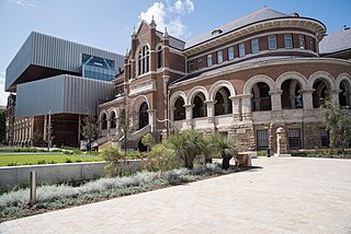
Perth is the capital and largest city of the Australian state of Western Australia. It is the fourth most populous city in Australia and Oceania, with a population of 2.1 million living in Greater Perth in 2020. Perth is part of the South West Land Division of Western Australia, with most of the metropolitan area on the Swan Coastal Plain between the Indian Ocean and the Darling Scarp. The city has expanded outward from the original British settlements on the Swan River, upon which the city's central business district and port of Fremantle are situated. Perth is located on the traditional lands of the Whadjuk Noongar people, where Aboriginal Australians have lived for at least 45,000 years.

Northam is a town in the Australian state of Western Australia, situated at the confluence of the Avon and Mortlock Rivers, about 97 kilometres (60 mi) east-northeast of Perth in the Avon Valley. At the 2016 census, Northam had a population of 6,548. Northam is the largest town in the Avon region. It is also the largest inland town in the state not founded on mining.

Hamersley is a residential suburb 14 kilometres north-northwest of the central business district of Perth, the capital of Western Australia, and six kilometres (4 mi) from the Indian Ocean. The suburb adjoins two major arterial roads—Mitchell Freeway to the west and Reid Highway to the south—and is within the City of Stirling local government area. It was built during the late 1960s and 1970s as part of the Government of Western Australia's response to rapidly increasing land prices across the metropolitan area.

Wagin is a town and shire in the Wheatbelt region of Western Australia, approximately 225 km (139.81 mi) south-east of Perth on the Great Southern Highway between Narrogin and Katanning. It is also on State Route 107. The main industries are wheat and sheep farming.

Cue is a small town in the Mid West region of Western Australia, located 620 km north-east of Perth. At the 2016 census, Cue had a population of 178. Cue is administered through the Cue Shire Council, which has its chambers in the historic Gentlemans Club building. The current president is Ross Pigdon. The Cue Parliament is held twice yearly in May and November.

The Murchison River is the second longest river in Western Australia. It flows for about 820 km (510 mi) from the southern edge of the Robinson Ranges to the Indian Ocean at Kalbarri. The Murchison-Yalgar-Hope river system is the longest river system in Western Australia. It has a mean annual flow of 208 gigalitres, although in 2006, the peak year on record since 1967, flow was 1,806 gigalitres.

Coolgardie–Esperance Highway is a 370-kilometre (230 mi) Western Australian highway between Coolgardie and Esperance. It runs in a north–south direction linking the state's Eastern Goldfields to the coast.

Ballajura is a suburb of Perth, Western Australia, in the City of Swan local government area. Ballajura is located 14 km north of the Perth CBD. The postcode for the suburb is 6066.

Corrigin is a town in the central Wheatbelt region of Western Australia, 229 kilometres (142 mi) east-southeast of the state capital, Perth, Western Australia, along State Route 40. It is mostly a farming community focused on crops and sheep, and holds the world record of "the most dogs in a ute".

Pemberton is a town in the South West region of Western Australia, named after original settler Pemberton Walcott.

Coorow is a town in the Mid West region of Western Australia, 264 kilometres (164 mi) north of Perth.
Bullabulling is a small townsite located 526 km (327 mi) east of Perth, Western Australia on the Great Eastern Highway in the Goldfields-Esperance region.

South Western Highway is a highway in the South West region of Western Australia connecting Perth's southeast with Walpole. It is a part of the Highway 1 network for most of its length. It is about 406 kilometres (252 mi) long.
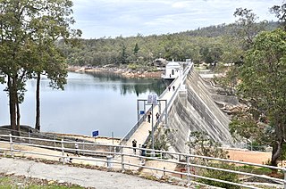
Mundaring Weir is a dam located 39 kilometres (24 mi) from Perth, Western Australia in the Darling Scarp. The dam and reservoir form the boundary between the suburbs of Reservoir and Sawyers Valley. The dam impounds the Helena River.

The Goldfields Water Supply Scheme is a pipeline and dam project that delivers potable water from Mundaring Weir in Perth to communities in Western Australia's Eastern Goldfields, particularly Coolgardie and Kalgoorlie. The project was commissioned in 1896 and completed in 1903.
Noonkanbah Station is a pastoral lease, both a cattle and sheep station, on the Fitzroy River between Camballin and Fitzroy Crossing in the south central Kimberley region of Western Australia.

Nungarin is a town located in the north east of the Wheatbelt region of Western Australia, approximately 278 kilometres (173 mi) east of Perth and 39 kilometres (24 mi) north of Merredin. It is the main town in the Shire of Nungarin. At the 2006 census, Nungarin had a population of 142.
Agnew is a ghost town in the Goldfields-Esperance region of Western Australia 982 kilometres (610 mi) north-east of Perth; the closest populated town is Leinster.
Nambi is a pastoral lease and sheep station located about 65 kilometres (40 mi) north east of Leonora and 110 kilometres (68 mi) south east of Leinster in the Goldfields of Western Australia.
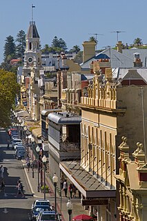
High Street is the main street running through the City of Fremantle, Western Australia. The street passes by historic landmarks, including the Round House, the Fremantle Town Hall, and the Fremantle War Memorial, through the Fremantle West End Heritage area and through two town squares. Trams operated along High Street for 47 years, between 1905 and 1952. Running east–west, High Street continues as Leach Highway, a major arterial road, at Stirling Highway, linking Fremantle with Perth Airport although the stretch of road between Stirling Highway and Carrington Street is known locally—and signed—as High Street.

