
The Woolloongabba Fiveways is the intersection of 5 major roads at Woolloongabba, Brisbane, Queensland, Australia. The intersection gives its name to the surrounding commercial area.
The Woolloongabba Fiveways is the intersection of 5 major roads at Woolloongabba, Brisbane, Queensland, Australia. The intersection gives its name to the surrounding commercial area.
The intersection consists of: [1]
The Woolloongabba Railway Yards were once located on the corner of Main Street and Stanley Street (north-west of the Fiveways); the Woolloongabba busway station is there today. The Gabba sporting grounds are located to the north-east of the Fiveways (on the block at the corner of Main Street and Stanley Street East). [1] [2]
The intersection of Brisbane's major roads on the southern side of the Brisbane River is of the major intersections in Brisbane's history with the first track to Ipswich (now Ipswich Road) established in the 1840s. [2]
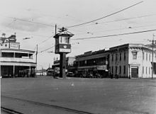
The Woolloongabba Railway Station constructed in 1887 with the associated railway yards being built in 1900. The Wooloongabba Branch railway line passed through the intersection until the closure of the yards and lines in the late 1960s. As tram routes also ran through the intersection, the management of 5 major road routes with car and buses, plus trams and trains travelling on their own tracks through the intersection made it Brisbane's busiest intersection. [2] A signalman's box was in the centre of the intersection to manage the transit of trains through the intersection.

The South East Busway is a grade separated bus-only road running south from the Brisbane central business district to Eight Mile Plains in Queensland, Australia. The busway was completed to Woolloongabba in September 2000 and to Eight Mile Plains in April 2001. An extension of the busway to School Road at Rochedale was completed in 2014 with no additional busway stations. The maximum capacity of the busway is 18,000 commuters an hour during peak periods. The busway carries an estimated 70 million passengers annually.

Dutton Park is an inner southern suburb in the City of Brisbane, Queensland, Australia. In the 2021 census, Dutton Park had a population of 2,134 people.

Woolloongabba is an inner southern suburb in the City of Brisbane, Queensland, Australia. In the 2021 census, Woolloongabba had a population of 8,687 people.

East Brisbane is an inner southern suburb of the City of Brisbane, Queensland, Australia. In the 2021 census, East Brisbane had a population of 6,186 people.

Logan Road, allocated state routes 95 and 30, is a major road in Brisbane, Queensland. It runs 18 kilometres (11 mi) from Springwood in Logan City to Woolloongabba in Brisbane, with most of the route signed as state route 95. The route was formerly the main route to the Gold Coast from Brisbane, until the South East Freeway was built.

The Brisbane tramway network served the city of Brisbane, Australia, between 1885 and 1969. It ran on standard gauge track. The electric system was originally energised to 500 volts, and subsequently increased to 600 volts. All tramcars built in Brisbane up to 1938 had an open design. This proved so popular, especially on hot summer nights, that the trams were used as fundraisers and often chartered right up until the last service by social groups.

Ipswich Road is major road in the City of Brisbane, Queensland, Australia. The road has been an important transport route since the 19th century when it connected the towns of Brisbane and Ipswich. In the 1990s, the section from Moorooka in Brisbane to Riverview in Ipswich was replaced by the Ipswich Motorway.
Stanley Street is a major street in Brisbane, Queensland. It carries the designation state route 41 for the entirety of its length and state route 10 between the Vulture Street and Annerley Road intersections. For the majority of its length the road is a one-way carriageway westbound. The route is a major connector between the Southern and Eastern suburbs and South Brisbane. The street passes directly to the south of The Gabba and runs directly through the Mater Hospital precinct.

Buranda is a neighbourhood in the southern Brisbane suburbs of Greenslopes and Woolloongabba in Brisbane, the capital of Queensland, Australia.
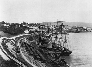
The Wooloongabba Branch railway line was a branch line off the South Coast railway line in the inner southern suburbs of Brisbane, Australia. It opened on 2 June 1884 to serve the wharves and industries along the Brisbane River at Woolloongabba and South Brisbane. Queensland Railways always referred to the line as the Wooloongabba Branch, despite the official spelling of the suburb it ran through being Woolloongabba.

Old Cleveland Road is a major road in Brisbane, Queensland. It runs 19.3 kilometres (12.0 mi) from Stones Corner to Capalaba in Brisbane, with most of the route signed as State Route 22. Sections of the road are also part of State Routes 30, 54, and 55. The road is the main route from inner Brisbane to Capalaba and Cleveland since New Cleveland Road only links Tingalpa with Capalaba.
Annerley Road is an arterial road in Brisbane, Queensland, Australia. It was formerly known as Boggo Road due to the boggy condition of the road.
Woolloongaba Post Office is a heritage-listed former post office at 765 Stanley Street, Woolloongabba, City of Brisbane, Queensland, Australia. It was designed by Thomas Pye and built in 1905 by Thomas Rees. It is also known as Woolloongabba Post & Telegraph Office. It was added to the Queensland Heritage Register on 24 January 2003.
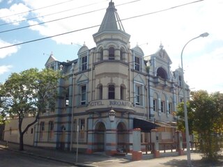
Broadway Hotel is a heritage-listed hotel at 93 Logan Road, Woolloongabba, City of Brisbane, Queensland, Australia. It was designed by John Hall & Son and constructed from 1889 to c. 1942 by Wooley & Whyte. It was added to the Queensland Heritage Register on 21 October 1992. The building has been in a state of significant disrepair and neglect for several years, covered in graffiti and broken panelling, and in September 2018 was destroyed by a fire.

Norman Hotel is a heritage-listed hotel at 102 Ipswich Road, Woolloongabba, City of Brisbane, Queensland, Australia. It was designed by John Beauchamp Nicholson and built from 1889 to 1890. It was added to the Queensland Heritage Register on 12 July 2005.

Taylor–Heaslop Building is a heritage-listed commercial building at 10–14 Logan Road, Woolloongabba, City of Brisbane, Queensland, Australia. It was designed by John Beauchamp Nicholson and built from 1889 to 1890. It is also known as Ernest Reid (draper), John Evan's Cash Draper, George Logan Draper, Johns & Co Draper, People's Cash Store (grocers), JR Blane, and Moreton Rubber Works. It was added to the Queensland Heritage Register on 6 February 2006.

Clarence Corner is the junction of Stanley Street and Annerley Road in Woolloongabba/South Brisbane in Brisbane, Queensland, Australia. It gives its name to the local area.

Pollock's Shop House is a heritage-listed general store at 617–619 Stanley Street, Woolloongabba, City of Brisbane, Queensland, Australia. It was built c. 1865. It was added to the Queensland Heritage Register on 21 October 1992.

The Normanby Fiveways is the intersection of five major roads to the north-east of the Brisbane central business district, Queensland, Australia.

Roma Street is a major street in Brisbane, the capital of Queensland, Australia. It is named after Diamantina Bowen, the wife of the first Governor of Queensland, George Bowen.