Charlotte Street, Brisbane

Last updated

Map of Brisbane City streets Brisbane map of city cbd.png
Map of Brisbane City streets

Charlotte Street is a road in the central business district of Brisbane, Queensland, Australia. The street is one of a number that were named after female queens and princesses of the royal family shortly after the penal colony was settled. Mary Street runs parallel to the south and Elizabeth Street is the next street to the north.

Contents

The one-directional road begins at a T-intersection where Creek Street becomes Eagle Street, close to the Brisbane River. Charlotte Street ends at another T-intersection with George Street. Here lies the 111 George Street tower containing mostly government offices.

Charlotte Street in 2019 Charlotte Street, Brisbane, Queensland in 2019.jpg
Charlotte Street in 2019

Charlotte Towers and Festival Towers are two tall residential buildings in Charlotte Street. The Elizabeth Arcade, St Stephens Cathedral, Comalco Place and The Pancake Manor are some of the other notable buildings located on Charlotte Street.

A number of multi-storey car parks have been built on the road. A police station once located on the Queen Street Mall was transferred to Charlotte Street. The iconic Victory Hotel, also on Charlotte Street, closed on 27 July 2008 after a fire destroyed the premises. [1] It has since re-opened in its original form.

History

Congregation of St George's Greek Orthodox Church in Charlotte Street, 1929 Congregation of St George's Greek Orthodox Church in Charlotte Street, Brisbane in 1929.jpg
Congregation of St George's Greek Orthodox Church in Charlotte Street, 1929

The Greek Association of Brisbane was established in 1913. In May 1921 it purchased Concordia Hall at 44-48 Charlotte Street ( 27°28′18″S153°01′33″E / 27.4717°S 153.0259°E / -27.4717; 153.0259 (St George's Greek Orthodox Church (1929-1960)) ) and renamed it Hellenic House to be used as a gathering place for the Greek community. [2] Greek Orthodox services in Brisbane were initially conducted in St Luke's Anglican Church (also in Charlotte Street) and the Wharf Street Congregational Church, [3] [4] until St George's was officially opened as the first Greek Orthodox church in Queensland in front of Hellenic House on 30 March 1929. [5] [6] However, the growth in Brisbane's Greek population, particularly after World War II, resulted in a need for a larger church. A new St George's Greek Orthodox Church was built at 33 Edmondstone Street (corner Besant Street) at South Brisbane ( 27°28′48″S153°00′56″E / 27.4799°S 153.0156°E / -27.4799; 153.0156 (St George's Greek Orthodox Church (1960-)) ) and opened on 24 April 1960. [7] A new Greek community centre (now the Greek Club) was built beside the South Brisbane church, opening in 1976. The Charlotte Street property was sold in 1981 and the Greek buildings on the site no longer exist. [8]

Heritage listings

John Reid & Nephews Building facade, 2020 John Reid and Nephews Building facade at 26 & 36 Charlotte Street, Brisbane, Queensland.jpg
John Reid & Nephews Building facade, 2020
Pan Australia House facade, 2020 Pan Australia House facade, Charlotte Street, Brisbane 02.jpg
Pan Australia House facade, 2020

Charlotte Street has a number of heritage-listed sites, including:

Lost heritage includes:

Major intersections

See also

Related Research Articles

Albion, Queensland Suburb of Brisbane, Queensland, Australia

Albion is an inner north-eastern suburb in the City of Brisbane, Queensland, Australia. In the 2016 census, Albion had a population of 2,296 people.

Kangaroo Point, Queensland Suburb of Brisbane, Queensland, Australia

Kangaroo Point is an inner southern suburb in the City of Brisbane, Queensland, Australia. In the 2016 census, Kangaroo Point had a population of 8,063 people.

Fortitude Valley, Queensland Suburb of Brisbane, Queensland, Australia

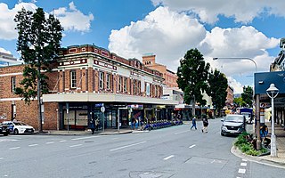
Fortitude Valley is an inner suburb of the City of Brisbane, the state capital of Queensland, Australia. In the 2021 census, Fortitude Valley had a population of 9,708 people. The suburb features two pedestrian malls at Brunswick Street Mall and Chinatown.

South Brisbane, Queensland Suburb of Brisbane, Queensland, Australia

South Brisbane is an inner southern suburb in the City of Brisbane, Queensland, Australia. In the 2016 census, South Brisbane had a population of 7,196 people.

<span class="mw-page-title-main">West End, Queensland</span> Suburb of Brisbane, Queensland, Australia

West End is an inner southern suburb in the City of Brisbane, Queensland, Australia. In the 2016 census, West End had a population of 9,474 people.

Windsor, Queensland Suburb of Brisbane, Queensland, Australia

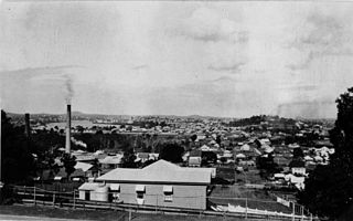
Windsor is an inner northern suburb in the City of Brisbane, Queensland, Australia. In the 2016 census, Windsor had a population of 7,013 people.

Woolloongabba Suburb of Brisbane, Queensland, Australia

Woolloongabba is a suburb in the City of Brisbane, Queensland, Australia. In the 2016 census, Woolloongabba had a population of 5,631 people.

Wynnum, Queensland Suburb of Brisbane, Queensland, Australia

Wynnum is a coastal suburb in the City of Brisbane, Queensland, Australia. In the 2016 census, Wynnum had a population of 12,915 people. The suburb is a popular destination in Brisbane due to its coastline, jetty and tidal wading pool.

Brisbane central business district Suburb of Brisbane, Queensland, Australia

Brisbane City is the central suburb and central business district of Brisbane, the state capital of Queensland, Australia. It is colloquially referred to as the "Brisbane CBD" or "the city". It is located on a point on the northern bank of the Brisbane River, historically known as Meanjin, Mianjin or Meeanjin in the local Aboriginal Australian dialect. The triangular shaped area is bounded by the median of the Brisbane River to the east, south and west. The point, known at its tip as Gardens Point, slopes upward to the north-west where the city is bounded by parkland and the inner city suburb of Spring Hill to the north. The CBD is bounded to the north-east by the suburb of Fortitude Valley. To the west the CBD is bounded by Petrie Terrace, which in 2010 was reinstated as a suburb.

Petrie Terrace, Queensland Suburb of Brisbane, Queensland, Australia

Petrie Terrace is an inner suburb in the City of Brisbane, Queensland, Australia. In the 2016 census, Petrie Terrace had a population of 1,124 people.

Spring Hill, Queensland Suburb of Brisbane, Queensland, Australia

Spring Hill is an inner northern suburb in the City of Brisbane, Queensland, Australia. In the 2016 census, Spring Hill had a population of 5,974 people.

<span class="mw-page-title-main">Queen Street, Brisbane</span> Street in Brisbanes CBD

Queen Street is the main street of Brisbane, the capital of Queensland, Australia. It is named after Queen Victoria of the United Kingdom.

George Street, Brisbane Street in Brisbane, Queensland

George Street is a major street located in the Brisbane CBD in Brisbane, Queensland, Australia.

St Lukes Church of England, Brisbane Heritage-listed building in Brisbane, Queensland

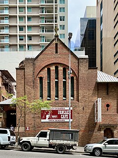
St Luke's Church of England, Brisbane is a heritage-listed former church and now restaurant at 18 Charlotte Street, Brisbane City, City of Brisbane, Queensland, Australia. It was designed by John Smith Murdoch and built in by John Steward & Co. It is also known as Pancake Manor. It was added to the Queensland Heritage Register on 21 October 1992.

Ann Street, Brisbane Street in Brisbane, Queensland

Ann Street runs parallel to Adelaide Street and is the northernmost street in the Brisbane CBD in Queensland, Australia. The street is named for Anne, Queen of Great Britain, as part of the CBD street naming series of female British royalty. It is a major thoroughfare, linking as a four-lane one-way street the suburb of Fortitude Valley in the northeast with the Riverside Expressway in the southwest; house numbers run the opposite direction.

Edward Street, Brisbane Street in Brisbane, Queensland, Australia

Edward Street is a busy thoroughfare in the Brisbane central business district, Queensland, Australia. It is a one-way street located between Albert Street and Creek Street, and runs from Upper Edward Street to Alice Street. It is named after Edward VII of the United Kingdom.

Elizabeth Street, Brisbane Street in Brisbane, Queensland

Elizabeth Street is a major street in the centre of the city in Brisbane, Queensland, Australia. The street was one of the earliest in Brisbane being established at the beginning of settlement in Brisbane as Moreton Bay penal settlement. Today, most of the street is fronted by low-level retail outlets, with an increase in mixed use skyscrapers being recently constructed.

Mary Street, Brisbane Street in Brisbane, Queensland

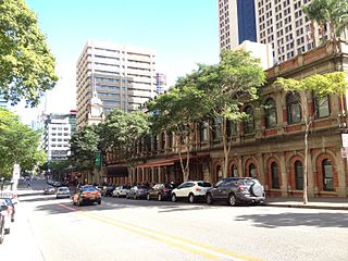
Mary Street is a major road in the Brisbane central business district. The street is one of a number that were named after female queens and princesses of the royal family shortly after the penal colony was settled. Charlotte Street is positioned parallel to the north and Margaret Street runs next to the south.

Creek Street, Brisbane Major road in Brisbane, Australia

Creek Street is a major street in the central business district of Brisbane, Queensland, Australia. The street follows a one-way south–north direction, starting at the beginning of Charlotte Street and cutting through Elizabeth Street, Queen Street, Adelaide Street, and Ann Street before coming to an end at Turbot Street in the northern end of the CBD. Creek Street was named for the filled-in creek over which it was constructed, and is an exception to the convention of parallel streets in the CBD being named after male royals.

John Mills Himself Building Heritage-listed building in Brisbane, Queensland

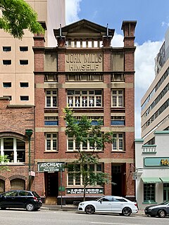
John Mills Himself Building is a heritage-listed warehouse at 40 Charlotte Street, Brisbane City, City of Brisbane, Queensland, Australia. It was built in 1919. It was added to the Queensland Heritage Register on 21 October 1992.

References

  1. Simon O'Brien (14 August 2008). "Victory patrons call for rise from the ashes". Brisbane Times . Retrieved 10 September 2008.
  2. "CONCORDIA HALL". The Brisbane Courier . No. 19, 766. Queensland, Australia. 28 May 1921. p. 5. Retrieved 6 August 2020 via National Library of Australia.
  3. "ANGLICAN CHURCH". The Telegraph . No. 16, 010. Queensland, Australia. 22 March 1924. p. 18. Retrieved 5 August 2020 via National Library of Australia.
  4. "New Greek Pastor". The Week (Brisbane) . Vol. CV, no. 2, 725. Queensland, Australia. 16 March 1928. p. 16. Retrieved 5 August 2020 via National Library of Australia.
  5. "GREEK CHURCH". The Telegraph . No. 17, 573. Queensland, Australia. 1 April 1929. p. 8. Retrieved 5 August 2020 via National Library of Australia.
  6. "THE FIRST IN THE State". The Evening News . No. 2360. Queensland, Australia. 2 April 1929. p. 8. Retrieved 5 August 2020 via National Library of Australia.
  7. "History of the Greek Orthodox Church in Brisbane". Brisbane Times. 27 April 2014. Retrieved 5 August 2020.
  8. "Church History". GOC St George. Retrieved 5 August 2020.
  9. "Pancake Manor (entry 600083)". Queensland Heritage Register . Queensland Heritage Council. Retrieved 19 June 2013.
  10. "John Reid and Nephews Building facade". Brisbane Heritage Register. Brisbane City Council . Retrieved 10 March 2015.
  11. "John Mills Himself Building (entry 600084)". Queensland Heritage Register . Queensland Heritage Council. Retrieved 19 June 2013.
  12. "George Weston and Sons Workshop". Brisbane Heritage Register. Brisbane City Council . Retrieved 10 March 2015.
  13. "Pan Australia House facade". Brisbane Heritage Register. Brisbane City Council . Retrieved 10 March 2015.
  14. "Charlotte House (entry 600082)". Queensland Heritage Register . Queensland Heritage Council. Retrieved 19 June 2013.
  15. "Walter Reid Building facade". Brisbane Heritage Register. Brisbane City Council . Retrieved 10 March 2015.
  16. "F.H. Faulding Warehouse". Brisbane Heritage Register. Brisbane City Council . Retrieved 10 March 2015.
  17. "St Stephens School (entry 600106)". Queensland Heritage Register . Queensland Heritage Council. Retrieved 19 June 2013.
  18. "Early Streets of Brisbane (entry 700011)". Queensland Heritage Register . Queensland Heritage Council. Retrieved 19 June 2013.
  19. "Government Printing Office (former) (entry 600114)". Queensland Heritage Register . Queensland Heritage Council. Retrieved 19 June 2013.

Coordinates: 27°28′14.54″S153°01′38.40″E / 27.4707056°S 153.0273333°E / -27.4707056; 153.0273333