Fordsdale, Queensland

Last updated

Map all coordinates using: OpenStreetMap  
Download coordinates as: KML
Fordsdale
Queensland
Fordsdale School of Arts.jpg
School of Arts hall, 2014
Australia Queensland location map.svg
Red pog.svg
Fordsdale
Coordinates 27°43′41″S152°05′34″E / 27.7280°S 152.0927°E / -27.7280; 152.0927 (Fordsdale (centre of locality)) Coordinates: 27°43′41″S152°05′34″E / 27.7280°S 152.0927°E / -27.7280; 152.0927 (Fordsdale (centre of locality))
Population52 (2016 census) [1]
 • Density0.804/km2 (2.082/sq mi)
Postcode(s) 4343
Area64.7 km2 (25.0 sq mi)
Time zone AEST (UTC+10:00)
Location
LGA(s) Lockyer Valley Region
State electorate(s) Lockyer
Federal division(s) Wright
Suburbs around Fordsdale:
Rockmount Egypt
Mount Whitestone
Mount Whitestone
Ramsay Fordsdale Mount Whitestone
West Haldon West Haldon West Haldon

Fordsdale is a rural locality in the Lockyer Valley Region, Queensland, Australia. [2] In the 2016 census, Fordsdale had a population of 52 people. [1]

Contents

Geography

The terrain in the area is rugged. Lower areas along the creeks have been farmed while the steep and elevated parts remain vegetated. Silky Oak Creek joins Ma Ma Creek, a tributary of Lockyer Creek at Fordsdale. Dwyers Scrub Regional Park has been established in the west.

The Gatton–Clifton Road runs through from north-east to south. [3]

History

The locality is said to be named after William Thomas Ford, a farmer of Mount Whitestone, who carried the mail from Grantham to Mount Whitestone run from 1896. [2] [4]

Ma Ma Creek Upper Provisional School opened on 8 July 1895 with Mr H. C. Tronc as headmaster. In 1906, it was renamed Fordsdale Provisional School. On 1 January 1909, it became Fordsdale State School. In April 1929, it was closed but reopened in 1931. [5] It was at 1902 Gatton Clifton Road ( 27°42′29″S152°07′43″E / 27.7081°S 152.1285°E / -27.7081; 152.1285 (Fordsdale State School (former)) ). [6]

Fordsdale School of Arts was officially opened on 27 May 1932 by Councillor Byrne, chairman of the Tarampa Shire Council. [7] [8]

In 1933, the school closed again. It reopened in 1937 with Miss E. G. M. Allen as head teacher with classes being held in the School of Arts as it was thought to be a more central location. As attendance at the new location was successfully maintained, it was decided to build a new school building on a site donated by Mr W. Bynon. The new school was officially opened on Saturday 3 June 1939 by the Leader of the Opposition, Ted Maher. [9] [10] The school closed in 1967. [5]

At the 2011 census, Fordsdale and surrounds recorded a population 211. [11]

In the 2016 census, Fordsdale had a population of 52 people. [1]

Education

There are no schools in Fordsdale. The nearest primary school is Mount Whitestone State School in neighbouring Mount Whitestone to the north-east. The nearest secondary schools are Lockyer District State High School in Gatton to the north-east and Centenary Heights State High School in Centenary Heights in Toowoomba to the north-west. [12]

Amenities

Fordsdale School of Arts Hall is at 2085 Gatton Clifton Road ( 27°43′11″S152°07′09″E / 27.7196°S 152.1193°E / -27.7196; 152.1193 (Fordsdale School of Arts Hall) ). [13]

Related Research Articles

Gatton, Queensland Town in Queensland, Australia

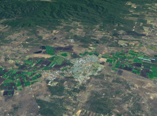
Gatton is a rural town and locality in the Lockyer Valley Region, Queensland, Australia. In the 2016 census, the locality of Gatton had a population of 7,101 people.

Ma Ma Creek, Queensland Town in Queensland, Australia

Ma Ma Creek is a rural town and a locality in the Lockyer Valley Region, Queensland, Australia. In the 2016 census, Ma Ma Creek had a population of 149 people.

Blanchview is a rural locality in the Lockyer Valley Region, Queensland, Australia. In the 2016 census, Blanchview had a population of 191 people.

Lockrose Suburb of Lockyer Valley Region, Queensland, Australia

Lockrose is a rural locality split between the Lockyer Valley Region and Somerset Region of Queensland, Australia. In the 2016 census, Lockrose had a population of 562 people.

Blenheim is a rural locality in the Lockyer Valley Region, Queensland, Australia. In the 2016 census, Blenheim had a population of 291 people.

Flagstone Creek is a rural locality in the Lockyer Valley Region, Queensland, Australia. In the 2016 census, Flagstone Creek had a population of 220 people.

Lower Tenthill, Queensland Suburb of Lockyer Valley Region, Queensland, Australia

Lower Tenthill is a rural locality in the Lockyer Valley Region, Queensland, Australia. In the 2016 census, Lower Tenthill had a population of 252 people.

Winwill, Queensland Suburb of Lockyer Valley Region, Queensland, Australia

Winwill is a rural locality in the Lockyer Valley Region, Queensland, Australia. In the 2016 census, Winwill had a population of 149 people.

Mount Whitestone, Queensland Suburb of Lockyer Valley Region, Queensland, Australia

Mount Whitestone is a locality in the Lockyer Valley Region, Queensland, Australia. In the 2016 census, Mount Whitestone had a population of 154 people.

West Haldon, Queensland Suburb of Toowoomba Region, Queensland, Australia

West Haldon is a locality split between Toowoomba Region and Lockyer Valley Region in Queensland, Australia. In the 2016 census, West Haldon had a population of 62 people.

Adare is a rural locality in the Lockyer Valley Region, Queensland, Australia. In the 2016 census, Adare had a population of 873 people.

Glen Cairn is a rural locality in the Lockyer Valley Region, Queensland, Australia. In the 2016 census, Glen Cairn had a population of 113 people.

Caffey, Queensland Suburb of Lockyer Valley Region, Queensland, Australia

Caffey is a rural locality in the Lockyer Valley Region, Queensland, Australia. In the 2016 census, Caffey had a population of 65 people.

Ingoldsby is a rural locality in the Lockyer Valley Region, Queensland, Australia. In the 2016 census, Ingoldsby had a population of 70 people.

Junction View is a rural locality in the Lockyer Valley Region, Queensland, Australia. In the 2016 census, Junction View had a population of 52 people.

Mount Berryman is a rural locality in the Lockyer Valley Region, Queensland, Australia. In the 2016 census, Mount Berryman had a population of 109 people.

Rockmount is a rural locality in the Lockyer Valley Region, Queensland, Australia. In the 2016 census, Rockmount had a population of 87 people.

Upper Tenthill, Queensland Suburb of Lockyer Valley Region, Queensland, Australia

Upper Tenthill is a rural locality in the Lockyer Valley Region, Queensland, Australia. In the 2016 census, Upper Tenthill had a population of 234 people.

Black Duck Creek is a rural locality in the Lockyer Valley Region, Queensland, Australia. In the 2016 census, Black Duck Creek had a population of 21 people.

Gatton–Clifton Road is a continuous 63.1 kilometres (39.2 mi) road route in the Lockyer Valley and Toowoomba regions of Queensland, Australia. Most of the road is signed as State Route 80. Gatton–Clifton Road is a state-controlled road, part regional and part district. The district part is rated as a local road of regional significance (LRRS).

References

  1. 1 2 3 Australian Bureau of Statistics (27 June 2017). "Fordsdale (SSC)". 2016 Census QuickStats. Retrieved 20 October 2018. OOjs UI icon edit-ltr-progressive.svg
  2. 1 2 "Fordsdale – locality in Lockyer Valley Region (entry 49516)". Queensland Place Names. Queensland Government . Retrieved 27 December 2020.
  3. Fordsdale, Queensland (Map). OpenStreetMap. Retrieved 3 March 2022.
  4. "Country Correspondence". Queensland Times, Ipswich Herald And General Advertiser . Vol. XXXVII, no. 5530. Queensland, Australia. 17 December 1896. p. 6. Archived from the original on 9 February 2021. Retrieved 17 November 2019 via National Library of Australia.
  5. 1 2 Queensland Family History Society (2010), Queensland schools past and present (Version 1.01 ed.), Queensland Family History Society, ISBN   978-1-921171-26-0
  6. "Helidon" (Map). Queensland Government. 1936. Retrieved 8 June 2022.
  7. "MA MA CREEK". The Brisbane Courier . No. 23, 197. Queensland, Australia. 4 June 1932. p. 16. Retrieved 8 June 2022 via National Library of Australia.
  8. "FORDSDALE". Queensland Times . Vol. LXXII, no. 14, 423. Queensland, Australia. 8 June 1932. p. 12 (DAILY). Retrieved 8 June 2022 via National Library of Australia.
  9. "NEW SCHOOL". Queensland Times . Vol. LXXIX, no. 16, 391. Queensland, Australia. 6 June 1939. p. 6 (DAILY.). Retrieved 8 June 2022 via National Library of Australia.
  10. "NEW SCHOOL AT FORDSDALE". The Courier-mail . No. 1797. Queensland, Australia. 6 June 1939. p. 4. Retrieved 8 June 2022 via National Library of Australia.
  11. Australian Bureau of Statistics (31 October 2012). "Fordsdale (Gazetted Locality)". 2011 Census QuickStats. Retrieved 20 October 2014. OOjs UI icon edit-ltr-progressive.svg
  12. "Queensland Globe". State of Queensland . Retrieved 9 February 2021.
  13. Fordsdale School of Arts (2007), Reflections of Fordsdale : Fordsdale School of Arts 1932-2007, Community Books Australia, ISBN   978-1-921151-79-8

Commons-logo.svg Media related to Fordsdale, Queensland at Wikimedia Commons