Moogerah, Queensland

Last updated

Moogerah
Queensland
Lake Moogerah Road bridge over Coulson Creek, Queensland 01.jpg
Lake Moogerah Road bridge over Coulson Creek, 2017
Australia Queensland location map.svg
Red pog.svg
Moogerah
Coordinates 28°06′35″S152°30′22″E / 28.1097°S 152.5061°E / -28.1097; 152.5061 (Moogerah (centre of locality))
Population242 (2021 census) [1]
 • Density1.574/km2 (4.078/sq mi)
Postcode(s) 4309
Area153.7 km2 (59.3 sq mi)
Time zone AEST (UTC+10:00)
Location
LGA(s) Scenic Rim Region
State electorate(s) Scenic Rim
Federal division(s) Wright
Suburbs around Moogerah:
Clumber Mount Edwards Charlwood
Clumber Moogerah Mount Alford
Emu Vale Carneys Creek Croftby

Moogerah is a rural locality in the Scenic Rim Region, Queensland, Australia. [2] In the 2021 census, Moogerah had a population of 242 people. [1]

Contents

Geography

Moogerah Dam, 2017 Moogerah Dam, Queensland 01.jpg
Moogerah Dam, 2017

The Moogerah Dam ( 28°01′46″S152°32′59″E / 28.0294°S 152.5497°E / -28.0294; 152.5497 (Moogerah Dam) ) and its reservoir, Lake Moogerah ( 28°03′00″S152°32′00″E / 28.05°S 152.5333°E / -28.05; 152.5333 (Lake Moogerah) ) [3] are located in the north of the locality. The lake is fed by Reynolds Creek. [4]

Moogerah has the following mountains:

History

The name Moogerah was used by Yuggera people, meaning thunder. [2]

In 1906, dairy farms of 81 to 261 acres (33 to 106 ha) were sold as the Moogera Paddock estate. The estate was centred around the confluence of Coulsen's and Reynold's Creek, land which is now under the Moogerah Dam. One of the advertised benefits of the estate was its proximity to the proposed Via Recta railway (a "straight" route from Brisbane to Sydney), which was never built. [11]

Moogerah Provisional School opened on 4 August 1908. It became Moogerah State School on 1 January 1909. The school closed in 1962. [12] It was at 1601 Lake Moogerah Road ( 28°04′09″S152°31′56″E / 28.0692°S 152.5321°E / -28.0692; 152.5321 (Moogerah State School (former)) ). [13] [4]

Construction of the Moogerah Dam commenced in 1959 and was completed in 1961. [14] Moogerah Dam Provisional School opened on 24 August 1959. It closed on 28 August 1961 with the remaining students transferred to Engelsburg State School in Kalbar (later renamed Kalbar State School). [12] [15]

Demographics

In the 2016 census, Moogerah had a population of 234 people. The locality contains 133 households, in which 47.8% of the population are males and 52.2% of the population are females with a median age of 50, 12 years above the national average. The average weekly household income is $945, $493 below the national average. 2.6% of Moogerah's population is either of Aborigional or Torres Strait Islander descent. 73.9% of the population aged 15 or over is either registered or de facto married, while 26.1% of the population is not married. 28.4% of the population is currently attending some form of a compulsory education. The most common nominated ancestries were Australian (28.8%), English (27.9%) and Irish (10.3%), while the most common country of birth was Australia (82.5%), and the most commonly spoken language at home was English (82.7%). The most common nominated religions were No religion (24.4%), Catholic (19.2%) and Not stated (16.2%). The most common occupation was a manager (28.9%) and the majority/plurality of residents worked 40 or more hours per week (52.4%). [16]

In the 2021 census, Moogerah had a population of 242 people. [1]

Amenities

Lake Moogerah, 2017 Lake Moogerah 02.jpg
Lake Moogerah, 2017

There are a number of boat ramps into Moogerah Dam, all managed by the Scenic Rim Regional Council: [17]

Related Research Articles

<span class="mw-page-title-main">Boonah, Queensland</span> Town in Queensland, Australia

Boonah is a rural town and locality in the Scenic Rim Region, Queensland, Australia. In the 2016 census, the locality of Boonah had a population of 2,484 people.

<span class="mw-page-title-main">Moogerah Dam</span> Dam in South East Queensland

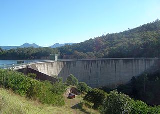
The Moogerah Dam is a mass concrete double curvature arch dam with an un-gated spillway across Reynolds Creek in South East Queensland, Australia, now within the locality of Moogerah in the Scenic Rim Region. The main purposes of the dam are for irrigation in the Reynolds Creek district and for supply of potable water to Warrill Creek and farmers in the Warrill Valley. The impounded reservoir is called Lake Moogerah.

<span class="mw-page-title-main">Aratula</span> Town in Queensland, Australia

Aratula is a rural town and locality in the Scenic Rim Region, Queensland, Australia. In the 2016 census, the locality of Aratula had a population of 532 people.

<span class="mw-page-title-main">Shire of Boonah</span> Local government area in Queensland, Australia

The Shire of Boonah was a local government area in South East Queensland, Australia, about 80 kilometres (50 mi) southwest of Brisbane. The shire covered an area of 1,921.6 square kilometres (741.9 sq mi), and existed from 1880 until its merger with parts of the Shire of Beaudesert and City of Ipswich to form the Scenic Rim Region on 15 March 2008.

<span class="mw-page-title-main">Scenic Rim Region</span> Local government area in Queensland, Australia

The Scenic Rim Region is a local government area in West Moreton region of South East Queensland, Australia. Established in 2008, it was preceded by several previous local government areas with histories extending back to the early 1900s and beyond. The main town of the region is Beaudesert.

<span class="mw-page-title-main">Kalbar, Queensland</span> Town in Queensland, Australia

Kalbar is a rural town and locality in the Scenic Rim Region, Queensland, Australia. In the 2016 census, the locality of Kalbar had a population of 1,093 people.

<span class="mw-page-title-main">Mount Walker, Queensland</span> Suburb of Scenic Rim Region, Queensland, Australia

Mount Walker is a rural locality in the Scenic Rim Region, Queensland, Australia. In the 2021 census, Mount Walker had a population of 129 people.

<span class="mw-page-title-main">Munbilla, Queensland</span> Town in Queensland, Australia

Munbilla is a rural town and locality in the Scenic Rim Region, Queensland, Australia. In the 2016 census, the locality of Munbilla had a population of 100 people.

<span class="mw-page-title-main">Templin, Queensland</span> Suburb of Scenic Rim Region, Queensland, Australia

Templin is a rural locality in the Scenic Rim Region, Queensland, Australia. In the 2016 census, Templin had a population of 86 people.

<span class="mw-page-title-main">Silverdale, Queensland</span> Suburb of Scenic Rim Region, Queensland, Australia

Silverdale is a rural locality in the Scenic Rim Region, Queensland, Australia. In the 2021 census, Silverdale had a population of 112 people.

<span class="mw-page-title-main">Frazerview, Queensland</span> Suburb of Scenic Rim Region, Queensland, Australia

Frazerview is a rural locality in the Scenic Rim Region, Queensland, Australia. In the 2021 census, Frazerview had a population of 36 people.

<span class="mw-page-title-main">Teviotville, Queensland</span> Town in Queensland, Australia

Teviotville is a rural locality in the Scenic Rim Region, Queensland, Australia. In the 2021 census, Teviotville had a population of 114 people.

<span class="mw-page-title-main">Mount French, Queensland</span> Suburb of Scenic Rim Region, Queensland, Australia

Mount French is a rural locality in the Scenic Rim Region, Queensland, Australia. In the 2021 census, Mount French had a population of 105 people.

<span class="mw-page-title-main">Charlwood, Queensland</span> Suburb of Scenic Rim Region, Queensland, Australia

Charlwood is a rural locality in the Scenic Rim Region, Queensland, Australia. In the 2021 census, Charlwood had a population of 146 people.

<span class="mw-page-title-main">Fassifern, Queensland</span> Suburb of Scenic Rim Region, Queensland, Australia

Fassifern is a rural locality in the Scenic Rim Region, Queensland, Australia. In the 2021 census, Fassifern had a population of 18 people.

<span class="mw-page-title-main">Fassifern Valley, Queensland</span> Suburb of Scenic Rim Region, Queensland, Australia

Fassifern Valley is a rural locality in the Scenic Rim Region, Queensland, Australia. In the 2021 census, Fassifern Valley had a population of 112 people.

<span class="mw-page-title-main">Clumber, Queensland</span> Suburb of Scenic Rim Region, Queensland, Australia

Clumber is a rural locality in the Scenic Rim Region, Queensland, Australia. In the 2021 census, Clumber had a population of 91 people.

<span class="mw-page-title-main">Mount Edwards, Queensland</span> Suburb of Scenic Rim Region, Queensland, Australia

Mount Edwards is a rural locality in the Scenic Rim Region, Queensland, Australia. In the 2021 census, Mount Edwards had a population of 60 people.

Obum Obum is a rural locality in the Scenic Rim Region, Queensland, Australia. In the 2021 census, Obum Obum had a population of 129 people.

Burnett Creek is a rural locality in the Scenic Rim Region, Queensland, Australia. It borders New South Wales to the south. In the 2021 census, Burnett Creek had a population of 16 people.

References

  1. 1 2 3 Australian Bureau of Statistics (28 June 2022). "Moogerah (SAL)". 2021 Census QuickStats. Retrieved 28 February 2023. OOjs UI icon edit-ltr-progressive.svg
  2. 1 2 "Moogerah – locality in Scenic Rim Region (entry 45165)". Queensland Place Names. Queensland Government . Retrieved 20 July 2021.
  3. "Lake Moogerah – reservoir in Scenic Rim Regional (entry 22582)". Queensland Place Names. Queensland Government . Retrieved 20 July 2021.
  4. 1 2 "Queensland Globe". State of Queensland . Retrieved 31 December 2021.
  5. 1 2 3 4 5 6 "Mountain peaks and capes - Queensland". Queensland Open Data. Queensland Government. 12 November 2020. Archived from the original on 25 November 2020. Retrieved 25 November 2020.
  6. "Mount Alford – mountain in Scenic Rim Region (entry 302)". Queensland Place Names. Queensland Government . Retrieved 25 November 2020.
  7. "Mount Asplenium – mountain in Scenic Rim Region (entry 943)". Queensland Place Names. Queensland Government . Retrieved 25 November 2020.
  8. "Mount Greville – mountain in Scenic Rim Region (entry 14858)". Queensland Place Names. Queensland Government . Retrieved 25 November 2020.
  9. "Mount Neilson – mountain in Scenic Rim Region (entry 24017)". Queensland Place Names. Queensland Government . Retrieved 25 November 2020.
  10. "The Bluff – mountain in Scenic Rim Region (entry 33860)". Queensland Place Names. Queensland Government . Retrieved 25 November 2020.
  11. "Fassifern Estate Queensland" (1906) [Map]. Collections. State Library of Queensland.
  12. 1 2 Queensland schools past and present. Version 1.01. Queensland Family History Society. 2010. ISBN   978-1-921171-26-0.
  13. "Queensland Two Mile series sheet 2m38" (Map). Queensland Government. 1955. Archived from the original on 21 June 2021. Retrieved 31 December 2021.
  14. Heritage Trails of the Great South East. State of Queensland. 2000. p. 32. ISBN   0-7345-1008-X.{{cite book}}: |work= ignored (help)
  15. "History". Kalbar State School. 4 January 2019. Archived from the original on 18 November 2019. Retrieved 18 November 2019.
  16. Australian Bureau of Statistics (27 June 2017). "Moogerah (SSC)". 2016 Census QuickStats. Retrieved 20 October 2018. OOjs UI icon edit-ltr-progressive.svg
  17. 1 2 3 4 "Recreational Boating Facilities Queensland". Queensland Open Data. Queensland Government. 12 November 2020. Archived from the original on 22 November 2020. Retrieved 22 November 2020.

Further reading