Mount Lindesay (Queensland)

Last updated

Map all coordinates using: OpenStreetMap
Mount Lindesay
Queensland
Australia Queensland location map.svg
Red pog.svg
Mount Lindesay
Coordinates 28°19′50″S152°44′00″E / 28.3305°S 152.7333°E / -28.3305; 152.7333 (Mount Lindesay (centre of locality))
Population3 (2016 census) [1]
 • Density0.175/km2 (0.45/sq mi)
Postcode(s) 4287
Area17.1 km2 (6.6 sq mi)
Time zone AEST (UTC+10:00)
Location
LGA(s) Scenic Rim Region
State electorate(s) Scenic Rim
Federal division(s) Wright
Suburbs around Mount Lindesay:
Mount Barney Mount Barney Palen Creek
Mount Barney Mount Lindesay Palen Creek
Dairy Flat (NSW) Dairy Flat (NSW) Palen Creek
Mount Lindesay
Mount Lindesay Queensland.jpg
The distinctly shaped peak of Mount Lindesay
Highest point
Elevation 1,177 m (3,862 ft)
Geography
Australia Queensland relief location map.jpg
Red triangle with thick white border.svg
Mount Lindesay
Queensland, Australia
Parent range McPherson Range
Climbing
First ascent 1872

Mount Lindesay is a rural locality in the Scenic Rim Region, Queensland, Australia. [2] It borders New South Wales. [3] In the 2016 census, Mount Lindesay had a population of 3 people. [1]

Contents

The mountain of the same name (height 1,175 metres (3,855 ft) is on the south-west boundary of the locality ( 28°20′41″S152°43′22″E / 28.3447°S 152.7228°E / -28.3447; 152.7228 (Mount Lindesday (mountain)) ) on the border between Queensland and New South Wales. [4]

Geography

Mount Lindesay from the Mount Lindesay Highway Mount Lindesay Australia.jpg
Mount Lindesay from the Mount Lindesay Highway

The mountain lies on the Queensland-New South Wales border, approximately 140 km south west of Brisbane, Australia. Mount Lindesay is one of a number of peaks in the McPherson Range, and is remarkable for its tiered summit, the eroded remnant of lava flows from the nearby Focal Peak shield volcano. [5] The mountain is situated within the Mount Barney National Park in Queensland and the Border Ranges National Park in New South Wales. Apart from the northern slopes, the rest of the peak is covered in dense rainforest, and the summit is frequently in cloud and mist.[ citation needed ]

The Mount Lindesay Highway enters the locality from the north-east (Palen Creek), passes to the west side of the mountain, and exits to the south-west (Dairy Flat, New South Wales). [3]

History

On 6 July 1828, the botanist and explorer Allan Cunningham originally named this mountain Mount Hooker after botanist William Hooker and called another mountain (now Mount Barney) by the name Mount Lindesay after Colonel Patrick Lindesay, the Commandant of Troops in New South Wales 1827–1836. Sometime in the late 1830s or early 1840s, either the New South Wales Surveyor-General Thomas Mitchell, or Moreton District surveyor Robert Dixon, are believed to have changed the names to be Mount Lindesay and Mount Barney (after Lieutenant-Colonel George Barney) respectively. [4]

The first known European ascent of Mount Lindesay was most likely by Collector of Customs, William Thornton, and the Kinchela brothers, John and James, sometime between 1846 and 1848. [6] All were stationed in Queensland at the time and knew each other well with the Kinchela brothers based at Telemon station on the Upper Logan within sight of the mountain. [7]

The first recorded (and second) ascent of Mount Lindesay was made in May 1872, by Thomas de Montmorency Murray-Prior (1848-1902) and Phillip Walter Pears (1846-1924). At the time of the 1872 ascent, an Aboriginal elder at nearby Unumgar station claimed to Pears that his father had once climbed the peak. [8]

The second recorded (and third) ascent of Mount Lindesay was made in July 1890, by the Norwegian naturalist and explorer Carsten Egeberg Borchgrevink (1864-1934), then working in the district as a surveyor's labourer, and Edwin Villiers-Brown, of Beaudesert. There were a further eight recorded ascents by the late 1920s, when pioneering climbers such as Bert Salmon (1899-1982) started visiting the peak regularly. The first women to climb Mount Lindesay were Brisbane climbers Jean Easton and Nora Dimes, who made the ascent with Bert Salmon in March 1931. [7]

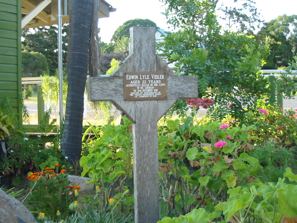
On 26 December 1928, Mount Lindesay was the site of the first known recreational climbing fatality in Australia, when Edwin Lyle Vidler fell to his death whilst attempting a solo ascent of Vidler's Chimney. He is buried in a grave in the rainforest, not far from where he fell. [9] [10] The crevice he attempted to climb up is now known as Vidler's Chimney and the first successful ascent was not until 1953. [11] In 1992, descendants of the Vidler family of Jamberoo erected a memorial outside the Rathdowney Information Centre and Historical Museum in Rathdowney. [12]

Mount Lindesay National Park was gazetted in 1947. In 1980, it was incorporated into an enlarged Mount Barney National Park. [13]

In August 1978 The Northern Star newspaper reported 3 local men (Stephen Marsh, Peter Taylor and Lewis Reid) climbed the mountain and signed a book in a metal container on the peak containing the names of members of another local expedition a few years earlier (John Martin, Barry Martin, Philip Martin, Raymond Martin, Neil Mahoney, George Ellen, John Gorman and John Bushell). [14]

On 29 November 2008, the mountain was part of a successful native title claim made by the Trevor Close on behalf of the Githabul people, [15] [16] for whom the peak holds a special significance. [15]

On 19 June 2011, Ross Miller, one of a party of six, fell to his death while climbing in a designated area. [17]

In the 2016 census, Mount Lindesay had a population of 3 people. [1]

In November 2019, a bushfire from the south burned across the mountain above the cliffs for the first time in living memory, reaching the summit from the western side. Most of the forest on top was burned, apart from several narrow bands on the lower veranda and a small area of rainforest, east of the summit. The fire significantly impacted the "tourist route", particularly on the lower cliff, with much of the vegetation destroyed, leaving unstable and potentially dangerous sections. Until the vegetation regenerates and the stability of the route improves, the risk of falling rock will remain high. The difficulties and seriousness have increased substantially as a result of the fire and it is not recommended for inexperienced climbers.[ citation needed ]

COVID-19 border checkpoint on the Mount Lindesay Highway, 16 January 2022 (the day after the borders re-opened) COVID-19 border checkpoint on the Mount Lindesay Highway from Queensland to New South Wales, 16 January 2022.jpg
COVID-19 border checkpoint on the Mount Lindesay Highway, 16 January 2022 (the day after the borders re-opened)

During the COVID-19 pandemic from March 2020 to 15 January 2022, there was a police checkpoint on the Mount Lindesday Highway where it crosses into New South Wales ( 28°20′13″S152°42′01″E / 28.33700°S 152.70030°E / -28.33700; 152.70030 (COVID border checkpoint) ) to restrict the movement of people and hence the transmission of COVID-19. [18] [19]

Education

There are no schools in Mount Lindesay. The nearest government primary school is Rathdowney State School in Rathdowney to the north-east. The nearest government secondary school is Beaudesert State High School in Beaudesert, further to the north-east. [3]

Attractions

The Mount Lindesay area circa 1955–1956.

Despite appearances, Mount Lindesay offers few opportunities for rock-climbers, due to the unsound nature of the rock (decaying rhyolite). There is one steep and exposed scrambling route to the summit, rated at approximately grade 6–7, which starts at the south east corner of the upper cliffs. However, this is not a bushwalking route as such, and anyone making an ascent should have basic rock-climbing and abseiling skills, or be under the guidance of experienced rock-climbers. [20]

See also

Related Research Articles

<span class="mw-page-title-main">Mount Barney National Park</span> Protected area in Queensland, Australia

Mount Barney National Park is a national park in Queensland (Australia), 90 km southwest of Brisbane. It amalgamated the adjacent Mount Lindesay National Park in 1980. It is part of the Scenic Rim Important Bird Area, identified as such by BirdLife International because of its importance in the conservation of several species of threatened birds.

<span class="mw-page-title-main">Mount Lindesay Highway</span> Highway in Queensland

Mount Lindesay Highway is an Australian national highway located in Queensland. The highway runs southwest from Brisbane, where it leaves Ipswich Road in the suburb of Moorooka, to the Queensland – New South Wales border and is 116 kilometres (72 mi) in length. For most of its length it is roughly aligned with the Sydney–Brisbane rail corridor. At its southern end these transport routes take different passes over the Scenic Rim into the Northern Rivers region. It is designated National Route 13.

<span class="mw-page-title-main">Rathdowney, Queensland</span> Town in Queensland, Australia

Rathdowney is a rural town and locality in the Scenic Rim Region, Queensland, Australia. In the 2016 census, Rathdowney had a population of 308 people.

<span class="mw-page-title-main">Logan River</span> River in Queensland, Australia

The Logan River is a perennial river in the Scenic Rim, Logan and Gold Coast local government areas of the South East region of Queensland, Australia. The 184-kilometre (114 mi)-long river is one of the dominant waterways in South East Queensland that drains the southern ranges of the Scenic Rim and empties into Moreton Bay after navigating the City of Logan, a major suburban centre located south of Brisbane. The catchment is dominated by urban and agricultural land use. Near the river mouth are mangrove forests and a number of aquaculture farms.

<span class="mw-page-title-main">McPherson Range</span> Mountain range in New South Wales, Australia

The McPherson Range is an extensive mountain range, a spur of the Great Dividing Range, heading in an easterly direction from near Wallangarra to the Pacific Ocean coastline. It forms part of the Scenic Rim on the border between the states of New South Wales and Queensland. Further west of the McPherson Range is the Main Range. Towards the coast the range continues into the Border Ranges and other mountainous terrain formed by the Tweed Volcano.

<span class="mw-page-title-main">Mount Barney (Queensland)</span> Mountain in Queensland, Australia

Mount Barney is a mountain within the Scenic Rim Region in south-east Queensland, Australia. It lies approximately 130 kilometres (81 mi) south-west of Brisbane, not far from the Queensland - New South Wales border, and forms part of the McPherson Range. It is a popular destination for bushwalkers and campers. Mount Barney is the sixth or seventh highest mountain in Queensland and is often regarded as one of the most impressive parts of the Scenic Rim. The mountain consists of two main peaks,, and smaller subsidiary peaks. East Peak is probably the most popular destination for bushwalkers.

<span class="mw-page-title-main">Mount Cordeaux</span> Mountain in Queensland, Australia

Mount Cordeaux is a mountain near Brisbane, Australia and rises 1,135 m. It lies to the immediate north of Cunninghams Gap in the Main Range National Park. It is known to the Aboriginal People as Niamboyoo, however, the meaning is unknown. It appears that early usage on names for the mountain varied, as a 29 September 1897 report in the Warwick Examiner and Times, refers to "the well-known Cunningham's Gap, with its twin sentinel peaks, Coonyinirra and Niamboyoo".

<span class="mw-page-title-main">Scenic Rim</span> Mountain ranges in Australia

The Scenic Rim is a group of forested mountain ranges of the Great Dividing Range, located south of Brisbane agglomeration, straddling the border between south-eastern Queensland and north-eastern New South Wales, Australia. In 2021, the Scenic Rim was named as a Lonely Planet top destination for 2022.

<span class="mw-page-title-main">Scenic Rim Region</span> Local government area in Queensland, Australia

The Scenic Rim Region is a local government area in West Moreton region of South East Queensland, Australia. Established in 2008, it was preceded by several previous local government areas with histories extending back to the early 1900s and beyond. The main town of the region is Beaudesert.

<span class="mw-page-title-main">Beaudesert Shire Tramway</span> Former tramway in Queensland, Australia

The Beaudesert Shire Tramway was a narrow gauge tramway which operated from Beaudesert to Lamington and Rathdowney in the Scenic Rim Region, Queensland, Australia, It was one of 15 light railways built and operated by Divisional Boards and Shire Councils in Queensland. The line carried passengers and cargo. It operated from 1903 to 1944. It was initially profitable and seen as a great success for the local shire council. The tramway is credited with opening up the agricultural lands of the upper Logan River.

<span class="mw-page-title-main">Maroon, Queensland</span> Suburb of Scenic Rim Region, Queensland, Australia

Maroon is a rural locality in the Scenic Rim Region, Queensland, Australia. In the 2016 census, Maroon had a population of 149 people.

<span class="mw-page-title-main">Barney View, Queensland</span> Suburb of Scenic Rim Region, Queensland, Australia

Barney View is a rural locality in the Scenic Rim Region, Queensland, Australia. In the 2016 census, Barney View had a population of 64 people.

<span class="mw-page-title-main">Palen Creek, Queensland</span> Suburb of Scenic Rim Region, Queensland, Australia

Palen Creek is a rural locality in the Scenic Rim Region, Queensland, Australia. It borders New South Wales. In the 2016 census, Palen Creek had a population of 280 people.

<span class="mw-page-title-main">Mount Gipps, Queensland</span> Suburb of Scenic Rim Region, Queensland, Australia

Mount Gipps is a rural locality in the Scenic Rim Region, Queensland, Australia. In the 2016 census, Mount Gipps had a population of 7 people.

<span class="mw-page-title-main">Innisplain, Queensland</span> Suburb of Scenic Rim Region, Queensland, Australia

Innisplain is a rural locality in the Scenic Rim Region, Queensland, Australia. In the 2016 census, Innisplain had a population of 85 people.

<span class="mw-page-title-main">Oaky Creek, Queensland</span> Suburb of Scenic Rim Region, Queensland, Australia

Oaky Creek is a rural locality in the Scenic Rim Region, Queensland, Australia. In the 2016 census Oaky Creek had a population of 83 people.

<span class="mw-page-title-main">Running Creek, Queensland</span> Suburb of Scenic Rim Region, Queensland, Australia

Running Creek is a rural locality in the Scenic Rim Region, Queensland, Australia. In the 2016 census, Running Creek had a population of 147 people. It borders New South Wales.

Burnett Creek is a rural locality in the Scenic Rim Region, Queensland, Australia. In the 2016 census, Burnett Creek had a population of 11 people. It borders New South Wales to the south.

Ipswich–Boonah–Rathdowney Road is a continuous 87.8 kilometres (54.6 mi) road route in the Ipswich and Scenic Rim regions of Queensland, Australia. It has two official names, Ipswich–Boonah Road and Boonah–Rathdowney Road. The entire route is signed as State Route 93, and much of it is also part of Tourist Drive 16.

Beaudesert–Boonah–Fassifern Road is a non-continuous 49.9 kilometres (31.0 mi) road route in the Scenic Rim region of Queensland, Australia. It has two official names, Beaudesert–Boonah Road and Boonah–Fassifern Road. The route is signed as State Route 90. These roads are joined by a 6.8 kilometres (4.2 mi) section of Ipswich-Boonah Road. Beaudesert–Boonah Road is a state-controlled regional road, and Boonah–Fassifern Road is also a state-controlled regional road. As part of State Route 90 it provides an alternate route between the Cunningham Highway and the Gold Coast.

References

  1. 1 2 3 Australian Bureau of Statistics (27 June 2017). "Mount Lindesay (SSC)". 2016 Census QuickStats. Retrieved 20 October 2018. OOjs UI icon edit-ltr-progressive.svg
  2. "Mount Lindesay – locality in Scenic Rim Region (entry 45174)". Queensland Place Names. Queensland Government . Retrieved 29 December 2020.
  3. 1 2 3 "Queensland Globe". State of Queensland . Retrieved 17 January 2022.
  4. 1 2 "Mount Lindesay – mountain in the Scenic Rim Region (entry 19447)". Queensland Place Names. Queensland Government . Retrieved 12 November 2019.
  5. R.W. Johnson, J. Knutson, S.R. Taylor, 1989,Intraplate Volcanism in Eastern Australia and New Zealand
  6. Mary Murray-Prior, 'An ascent of Mt. Lindesay', Queenslander, 1 November 1902, p.974
  7. 1 2 Thomson, Robert (2001), "The first ascent of Mt Lindesay: a climbing 'whodunit'", Queensland Review (published May 2001), 8 (1): 1–20, doi:10.1017/S1321816600002336, ISSN   1321-8166
  8. P.W. Pears, 'Mt. Lindesay', Brisbane Courier, 22 November 1923, p.6
  9. "A TRAGIC STORY". The Brisbane Courier . National Library of Australia. 4 January 1929. p. 15. Archived from the original on 14 January 2022. Retrieved 20 February 2014.
  10. "OBITUARY". The Queenslander . Queensland, Australia. 3 January 1929. p. 59. Retrieved 17 January 2022 via National Library of Australia.
  11. Meadows, Michael H (2015), The living rock : the invention of climbing in eastern Australia, Living Rock Press, p. 124, ISBN   978-0-9925440-2-7
  12. "Edwin Lyle VIDLER aged 22 years, accidentally killed on the cliffs of Mt. Lindesay of 26th December 1928. Erected by descendants of the Vidler pioneering family of Jamberoo in 1992" . Retrieved 17 January 2022.
  13. "Nature, culture and history: Mount Barney National Park". Parks and forests. Queensland Government. 19 October 2009. Archived from the original on 19 May 2021. Retrieved 14 January 2022.
  14. "Mountain Conquered by Woodenbong Men". The Northern Star. 2 August 1978.
  15. 1 2 "Githabul People's native title determination" (PDF). Native Title Tribunal. 29 November 2007. Archived (PDF) from the original on 21 March 2015. Retrieved 12 September 2015.
  16. "More native title claims planned for southern Qld". ABC News Online. Australian Broadcasting Corporation. 12 September 2007. Archived from the original on 26 January 2011. Retrieved 20 March 2011.
  17. "Tragedy on Mt Lindesay". Beaudesert Times. 23 June 2011. Archived from the original on 22 February 2014. Retrieved 26 March 2012.
  18. O'Brien, Rose (7 August 2020). "The Queensland Border 2020". Queensland Stories. Archived from the original on 20 January 2021. Retrieved 17 January 2022.
  19. "Queensland's COVID-19 border restrictions are set to be dumped. How will it work?". ABC News. 13 January 2022. Archived from the original on 16 January 2022. Retrieved 17 January 2022.
  20. R.Rankin, 1992, Secrets of the Scenic Rim

Commons-logo.svg Media related to Mount Lindesay, Queensland at Wikimedia Commons