Sarabah, Queensland

Last updated

Sarabah
Queensland
Australia Queensland location map.svg
Red pog.svg
Sarabah
Coordinates 28°07′08″S153°07′13″E / 28.1188°S 153.1202°E / -28.1188; 153.1202 (Sarabah (centre of locality))
Population68 (2021 census) [1]
 • Density2.957/km2 (7.66/sq mi)
Postcode(s) 4275
Area23.0 km2 (8.9 sq mi)
Time zone AEST (UTC+10:00)
Location
LGA(s) Scenic Rim Region
State electorate(s) Scenic Rim
Federal division(s) Wright
Suburbs around Sarabah:
Nindooinbah Canungra Ferny Glen
Nindooinbah Sarabah Illinbah
Cainbable O'Reilly Illinbah

Sarabah is a locality in the Scenic Rim Region, Queensland, Australia. [2] In the 2021 census, Sarabah had a population of 68 people. [1]

Contents

Geography

The locality is bounded to the west by the Sarabah Range and to the east by the Darlington Range with a valley in-between. Canungra Creek enters the locality from the south (O'Reilly) and forms part of the south-eastern boundary before flowing north through the valley and exiting to the north (Canungra). [3] The elevations range from 150 to 700 metres (490 to 2,300 ft) above sea level. [4]

A section of Lamington National Park is in the south-west of the locality. Apart from this protected area, the land use of the locality is predominantly grazing on native vegetation. [4]

There are two roads through the locality. Lamington National Park Road enters the locality from the north (Canungra) and loosely follows the western boundary of the locality (the Sarabah Range) before entering the locality's section of Lamington National Park, from which the road exits to the south-west (Cainbable). The other road, Sarabah Road, also enters from Canungra and travels along the valley floor (crossing the creek from time to time) providing access to the homes and farms, before exiting to the south-east (Illinbah). [4]

History

Sarabah Provisional School opened on 6 June 1892 and closed in June 1899. [5]

Demographics

In the 2016 census, Sarabah had a population of 55 people. The locality contains 25 households, in which 48.0% of the population are males and 52.0% of the population are females. The population's media age of 56 is 18 years above the national average. The average weekly household income is $1,437, $1 below the national average. [6]

In the 2021 census, Sarabah had a population of 68 people. [1]

Education

There are no schools in Sarabah. The nearest government primary school is Canungra State School in neighbouring Canungra to the north. The nearest government secondary school is Tamborine Mountain State High School in Tamborine Mountain to the north-east. [7]

Related Research Articles

<span class="mw-page-title-main">Canungra, Queensland</span> Town in Queensland, Australia

Canungra is a rural town and locality in the Scenic Rim Region, Queensland, Australia. In the 2021 census, the locality of Canungra had a population of 1,436 people.

<span class="mw-page-title-main">Scenic Rim</span> Mountain ranges in Queensland and New South Wales

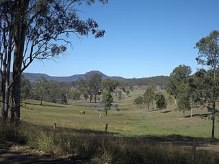
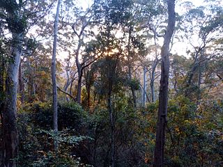
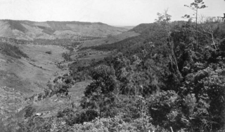
The Scenic Rim is a group of forested mountain ranges of the Great Dividing Range, located south of Brisbane agglomeration, straddling the border between south-eastern Queensland and north-eastern New South Wales, Australia. In 2021, the Scenic Rim was named as a Lonely Planet top destination for 2022.

<span class="mw-page-title-main">Beechmont, Queensland</span> Town in Queensland, Australia

Beechmont is a rural town and locality in the Scenic Rim Region, Queensland, Australia. In the 2021 census, the locality of Beechmont had a population of 848 people.

<span class="mw-page-title-main">Nindooinbah, Queensland</span> Suburb of Scenic Rim Region, Queensland, Australia

Nindooinbah is a rural locality in the Scenic Rim Region, Queensland, Australia. In the 2021 census, Nindooinbah had a population of 95 people.

<span class="mw-page-title-main">Wonglepong, Queensland</span> Suburb of Scenic Rim Region, Queensland, Australia

Wonglepong is a rural locality in the Scenic Rim Region, Queensland, Australia. In the 2021 census, Wonglepong had a population of 364 people.

Witheren is a rural locality in the Scenic Rim Region, Queensland, Australia. In the 2021 census, Witheren had a population of 581 people.

<span class="mw-page-title-main">Biddaddaba, Queensland</span> Suburb of Scenic Rim Region, Queensland, Australia

Biddaddaba is a rural locality in the Scenic Rim Region, Queensland, Australia. In the 2021 census, Biddaddaba had a population of 171 people.

<span class="mw-page-title-main">Boyland, Queensland</span> Suburb of Scenic Rim Region, Queensland, Australia

Boyland is a rural locality in the Scenic Rim Region, Queensland, Australia. In the 2021 census, Boyland had a population of 855 people.

<span class="mw-page-title-main">Illinbah, Queensland</span> Suburb of Scenic Rim Region, Queensland, Australia

Illinbah is a rural locality in the Scenic Rim Region, Queensland, Australia. In the 2021 census, Illinbah had a population of 128 people.

<span class="mw-page-title-main">Tamborine, Queensland</span> Town in Queensland, Australia

Tamborine is a rural town in the Scenic Rim Region and a locality split between the Scenic Rim Region and the City of Logan in Queensland, Australia. In the 2021 census, the locality of Tamborine had a population of 4,388 people.

<span class="mw-page-title-main">Binna Burra, Queensland</span> Suburb of Scenic Rim Region, Queensland, Australia

Binna Burra is a rural locality in the Scenic Rim Region, Queensland, Australia. It borders New South Wales. In the 2021 census, Binna Burra had "no people or a very low population".

<span class="mw-page-title-main">O'Reilly, Queensland</span> Suburb of Scenic Rim Region, Queensland, Australia

O'Reilly is a rural locality in the Scenic Rim Region, Queensland, Australia. It borders New South Wales. In the 2021 census, O'Reilly had a population of 114 people.

<span class="mw-page-title-main">Darlington, Queensland</span> Suburb of Scenic Rim Region, Queensland, Australia

Darlington is a rural locality in the Scenic Rim Region, Queensland, Australia. In the 2021 census, Darlington had a population of 98 people.

<span class="mw-page-title-main">Lamington, Queensland</span> Suburb of Scenic Rim Region, Queensland, Australia

Lamington is a rural locality in the Scenic Rim Region, Queensland, Australia. In the 2021 census, Lamington had a population of 89 people.

<span class="mw-page-title-main">Flying Fox, Queensland</span> Suburb of Scenic Rim Region, Queensland, Australia

Flying Fox is a rural locality in the Scenic Rim Region, Queensland, Australia. In the 2021 census, Flying Fox had a population of 61 people.

Benobble is a rural locality in the Scenic Rim Region, Queensland, Australia. In the 2021 census, Benobble had a population of 29 people.

<span class="mw-page-title-main">Cainbable, Queensland</span> Suburb of Scenic Rim Region, Queensland, Australia

Cainbable is a rural locality in the Scenic Rim Region, Queensland, Australia. In the 2021 census, Cainbable had a population of 85 people.

Ferny Glen is a rural locality in the Scenic Rim Region, Queensland, Australia. In the 2021 census, Ferny Glen had a population of 91 people.

<span class="mw-page-title-main">Frenches Creek, Queensland</span> Suburb of Scenic Rim Region, Queensland, Australia

Frenches Creek is a rural locality in the Scenic Rim Region, Queensland, Australia. In the 2021 census, Frenches Creek had a population of 91 people.

The Tamborine Mountain road network is a group of roads that provide access to the mountain community from various lowland localities. The network ensures continuity of access in times of flooding or other natural disasters, and during planned maintenance activities. The locality of Tamborine Mountain includes a plateau that hosts a substantial residential community plus many tourism accommodation and activity venues.

References

  1. 1 2 3 Australian Bureau of Statistics (28 June 2022). "Sarabah (SAL)". 2021 Census QuickStats. Retrieved 28 February 2023. OOjs UI icon edit-ltr-progressive.svg
  2. "Sarabah – locality in Scenic Rim Region (entry 45195)". Queensland Place Names. Queensland Government . Retrieved 13 September 2019.
  3. Google (15 September 2021). "Sarabah, Queensland" (Map). Google Maps . Google. Retrieved 15 September 2021.
  4. 1 2 3 "Queensland Globe". State of Queensland . Retrieved 31 December 2023.
  5. Queensland Family History Society (2010), Queensland schools past and present (Version 1.01 ed.), Queensland Family History Society, ISBN   978-1-921171-26-0
  6. Australian Bureau of Statistics (27 June 2017). "Sarabah (SSC)". 2016 Census QuickStats. Retrieved 20 October 2018. OOjs UI icon edit-ltr-progressive.svg
  7. "Layers: Locality; Schools and school catchments". Queensland Globe. Queensland Government. Archived from the original on 19 December 2017. Retrieved 31 December 2023.