Flying Fox, Queensland

Last updated

Flying Fox
Queensland
Queensland State Archives 451 Looking across Flying Fox towards Cainbable and Tamborine Beaudesert Shire November 1933.png
Looking across Flying Fox towards Cainbable and Tamborine, 1933
Australia Queensland location map.svg
Red pog.svg
Flying Fox
Coordinates 28°06′07″S153°10′14″E / 28.1019°S 153.1705°E / -28.1019; 153.1705 (Flying Fox (centre of locality)) Coordinates: 28°06′07″S153°10′14″E / 28.1019°S 153.1705°E / -28.1019; 153.1705 (Flying Fox (centre of locality))
Population65 (2016 census) [1]
 • Density7.56/km2 (19.58/sq mi)
Postcode(s) 4275
Area8.6 km2 (3.3 sq mi)
Time zone AEST (UTC+10:00)
Location
LGA(s) Scenic Rim Region
State electorate(s) Scenic Rim
Federal division(s) Wright
Suburbs around Flying Fox:
Ferny Glen Ferny Glen Witheren
Illinbah Flying Fox Beechmont
Illinbah Beechmont Beechmont

Flying Fox is a rural locality in the Scenic Rim Region, Queensland, Australia. [2] In the 2016 census, Flying Fox had a population of 65 people. [1]

Contents

Geography

The locality consists of a pair of north-south valleys. The watercourse Flying Fox Creek rises to the south (Beechmont) and flows north through the eastern valley of the locality of Flying Fox exiting to the north (Ferny Glen) where it becomes a tributary of the Coomera River. An unnamed creek also rises to the south (Beechmont) and flows north through the western valley of the locality of Flying Fox where it becomes a tributary of Flying Fox Creek on the locality's northern boundary. [3]

History

Flying Fox State School opened on 21 June 1920 and closed in 1962. [4] It was on the western side of Upper Coomera Road near the Coomera River (approx 28°04′52″S153°09′22″E / 28.0810°S 153.1561°E / -28.0810; 153.1561 (Flying Fox State School (former)) ), now within the present-day boundaries of neighbouring Ferny Glen. [5] [6] [3]

In the 2016 census, Flying Fox had a population of 65 people. [1] The locality contained 19 households, in which 53.8% of the population were males and 46.2% of the population were females with a median age of 41, 3 years above the national average. The average weekly household income was $2,399, $961 above the national average. [1]

Education

There are no schools in Flying Fox. The nearest government primary schools are Canungra State School in Canungra to the north and Beechmont State School in neighbouring Beechmont to the south-east. The nearest government secondary schools are Tamborine Mountain State High School in Tamborine Mountain to the north and Nerang State High School in Nerang to the north-east. [3]

Related Research Articles

Canungra, Queensland Town in Queensland, Australia

Canungra is a rural town and locality in the Scenic Rim Region, Queensland, Australia. In the 2016 census the locality of Canungra had a population of 1,229 people.

Scenic Rim Mountain ranges in Australia

The Scenic Rim is a group of forested mountain ranges of the Great Dividing Range, located south of Brisbane agglomeration, straddling the border between south-eastern Queensland and north-eastern New South Wales, Australia. In 2021, the Scenic Rim was named as a Lonely Planet top destination for 2022.

Numinbah Valley Town in Queensland, Australia

Numinbah Valley is a rural locality in the City of Gold Coast, Queensland, Australia. In the 2016 census, Numinbah Valley had a population of 218 people.

Scenic Rim Region Local government area in Queensland, Australia

The Scenic Rim Region is a local government area in West Moreton region of South East Queensland, Australia. Established in 2008, it was preceded by several previous local government areas with histories extending back to the early 1900s and beyond. The main town of the region is Beaudesert.

Beechmont, Queensland Suburb of Scenic Rim Region, Queensland, Australia

Beechmont is a rural town and locality in the Scenic Rim Region, Queensland, Australia. In the 2016 census, the locality of Beechmont had a population of 842 people.

Gold Coast hinterland

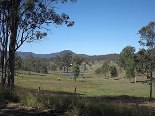
The Gold Coast hinterland is an area of South East Queensland, Australia that comprises the Tweed Range, Nimmel Range, Tamborine Mountain, Numinbah Valley, eastern parts of the McPherson Range and western parts of suburban Gold Coast, such as Mudgeeraba. This undefined unit of area is known for its tourist attractions including resorts, rainforest, lookouts, national parks, its diversity of fauna and flora and as a green backdrop to the coastal strip. It overlaps part of the Scenic Rim and is part of both the City of Gold Coast and Scenic Rim Region and includes Springbrook, Binna Burra and O'Reilly.

Nindooinbah, Queensland Suburb of Scenic Rim Region, Queensland, Australia

Nindooinbah is a rural locality in the Scenic Rim Region, Queensland, Australia. In the 2016 census Nindooinbah had a population of 80 people.

Wonglepong, Queensland Suburb of Scenic Rim Region, Queensland, Australia

Wonglepong is a rural locality in the Scenic Rim Region, Queensland, Australia. In the 2016 census Wonglepong had a population of 341 people.

Witheren is a rural locality in the Scenic Rim Region, Queensland, Australia. In the 2016 census Witheren had a population of 496 people.

Biddaddaba, Queensland Town in Queensland, Australia

Biddaddaba is a rural locality in the Scenic Rim Region, Queensland, Australia. In the 2016 census, Biddaddaba had a population of 171 people.

Boyland, Queensland Suburb of Scenic Rim Region, Queensland, Australia

Boyland is a rural locality in the Scenic Rim Region, Queensland, Australia. In the 2016 census Boyland had a population of 823 people.

Illinbah, Queensland Suburb of Scenic Rim Region, Queensland, Australia

Illinbah is a rural locality in the Scenic Rim Region, Queensland, Australia. In the 2016 census, Illinbah had a population of 129 people.

Lower Beechmont is a locality in the City of Gold Coast, Queensland, Australia. It is situated in the Gold Coast hinterland. In the 2016 census, Lower Beechmont had a population of 1,046 people.

Tamborine, Queensland Suburb of Logan City, Queensland, Australia

Tamborine is a town in the Scenic Rim Region and a locality split between the Scenic Rim Region and the City of Logan in Queensland, Australia. In the 2016 census, the locality of Tamborine had a population of 3,950 people.

Binna Burra, Queensland Suburb of Scenic Rim Region, Queensland, Australia

Binna Burra is a rural locality in the Scenic Rim Region, Queensland, Australia. It borders New South Wales. In the 2016 census, Binna Burra had a population of 4 people.

OReilly, Queensland Suburb of Scenic Rim Region, Queensland, Australia

O'Reilly is a rural locality in the Scenic Rim Region, Queensland, Australia. It borders New South Wales. In the 2016 census, O'Reilly had no population.

Beaudesert–Nerang Road is a major inter-regional arterial road that connects the township of Beaudesert with the Gold Coast via Canungra. The road commences in Nerang on the western edge of the Gold Coast and travels west through the Gold Coast hinterland and terminates in central Beaudesert at the intersection of Mount Lindesay Highway.

Benobble is a rural locality in the Scenic Rim Region, Queensland, Australia. In the 2016 census, Benobble had a population of 43 people.

Cainbable, Queensland Suburb of Scenic Rim Region, Queensland, Australia

Cainbable is a rural locality in the Scenic Rim Region, Queensland, Australia. In the 2016 census Cainbable had a population of 74 people.

Ferny Glen is a rural locality in the Scenic Rim Region, Queensland, Australia. In the 2016 census Ferny Glen had a population of 84 people.

References

  1. 1 2 3 4 Australian Bureau of Statistics (27 June 2017). "Flying Fox (SSC)". 2016 Census QuickStats. Retrieved 20 October 2018. OOjs UI icon edit-ltr-progressive.svg
  2. "Flying Fox – locality in Scenic Rim Region (entry 45140)". Queensland Place Names. Queensland Government . Retrieved 20 July 2021.
  3. 1 2 3 "Queensland Globe". State of Queensland . Retrieved 15 December 2021.
  4. Queensland Family History Society (2010), Queensland schools past and present (Version 1.01 ed.), Queensland Family History Society, ISBN   978-1-921171-26-0
  5. "Moreton 40 Chain map AG2 series sheet 14 south" (Map). Queensland Government. 1930. Archived from the original on 16 June 2020. Retrieved 15 December 2021.
  6. "Queensland Two Mile series sheet 2m38" (Map). Queensland Government. 1955. Archived from the original on 21 June 2021. Retrieved 15 December 2021.