Wonglepong, Queensland

Last updated

Wonglepong
Queensland
Tamborine Mountain 3.jpg
Wonglepong and surrounds
Australia Queensland location map.svg
Red pog.svg
Wonglepong
Coordinates 27°58′13″S153°09′27″E / 27.9702°S 153.1575°E / -27.9702; 153.1575 (Wonglepong (centre of locality))
Population364 (2021 census) [1]
 • Density43.9/km2 (113.6/sq mi)
Postcode(s) 4275
Area8.3 km2 (3.2 sq mi)
Time zone AEST (UTC+10:00)
Location
LGA(s) Scenic Rim Region
State electorate(s) Scenic Rim
Federal division(s) Wright
Suburbs around Wonglepong:
Boyland Boyland Tamborine Mountain
Biddaddaba Wonglepong Tamborine Mountain
Biddaddaba Benobble Benobble

Wonglepong is a rural locality in the Scenic Rim Region, Queensland, Australia. [2] In the 2021 census, Wonglepong had a population of 364 people. [1]

Contents

Geography

Wonglepong straddles a valley upstream from where Canungra Creek joins the Albert River. Development is centered along Beaudesert Nerang Road which passes through the lowest elevations. In the east the slopes of the valley rise sharply towards the Tamborine Mountain plateau.

History

The name Wonglepong was the name of the local railway station name from 1927 (previously known as Sarah Vale). Wonglepong is believed to be an Aboriginal name possibly meaning either forgotten sound or referring to some feature of Mount Tamborine. [2] The name has variant spellings such as Wangalpong. [3]

The Franklin family established a farm in the district called Sarahvale in 1875. [4] The family established a private cemetery on their land. In 1914, Ann Ford Franklin donated 1 acre (0.40 ha) of land including their cemetery to the Tamborine Shire Council (later the Beaudesert Shire Council, now the Scenic Rim Regional Council) for use as a public cemetery. It has been variously known as Sarahvale Cemetery, Lower Canungra Cemetery, Wanglepong Cemetery, and Wonglepong Cemetery. [5]

Caningera Provisional School opened in 1884 and closed in 1893. It re-opened and then closed twice in 1885 and 1887 as Canungra Creek Provisional School. On 20 September 1898 it re-opened as Canungera Lower Provisional School. On 1 January 1909, it became Canungera Lower State School. In 1915, it was renamed Wangalpong State School. In 1928, it was renamed Wonglepong State School. It closed on 13 September 1935. [6] [7] The school was within the present-day Henry Franklin Family Park on Mundoolun Connection Road. A commemorative plaque in the park marks the school's exact site ( 27°58′12″S153°09′47″E / 27.96994°S 153.16294°E / -27.96994; 153.16294 (Wonglepong State School (former)) ), using the name Caningera School. [3] [8] [9]

Wonglepong Methodist Church opened in 1906. [10] It was built by the Caswell family. By 1953, Canungra had overtaken Wonglepong as the centre of the district, but there was no Methodist church in Canungra (despite being planned for some years), so it was decided to donate the church in Wonglepong to assist the establishment of the church in Canungra. In late 1953, the Wonglepong church was demolished so its timbers and fittings could be re-cycled in the construction of the Canungra Methodist Church, which opened in June 1954. [11]

Wonglepong railway station ( 27°58′18″S153°09′46″E / 27.9716°S 153.1628°E / -27.9716; 153.1628 (Wonglepong railway station (former)) ) was on the Canungra railway line, which operated from 1915 to 30 June 1955. [12] [13]

The Wonglepong branch of the Queensland Country Women's Association was formed in 1925, founded by Ann Franklin. The branch met in her home for the first eight years, after which her poor health necessitated other members taking turns to host the meetings while funds were raised for a permanent hall. The Franklin family provided the land on a 99-year lease and provided the timber to build the hall. Ann Franklin's son, a carpenter, was in charge of the construction assisted by volunteer labour from the members' husbands. On 4 December 1935, the hall was officially opened by Mrs Buchanan, the President of Central Division of the QCWA. The hall included a library. [14] [15] [16] On 7 November 2015, the branch celebrated its 90th anniversary with the hall's 80th birthday being in December 2015. [17]

Demographics

In the 2011 census, Wonglepong recorded a population of 367 people. [18]

In the 2016 census, Wonglepong had a population of 341 people. [19]

In the 2021 census, Wonglepong had a population of 364 people. [1]

Heritage listings

Wonglepong QCWA Hall, 2006 Wonglepong QCWA Hall (2006), side view.jpg
Wonglepong QCWA Hall, 2006

Wonglepong has a number of heritage-listed sites, including:

Education

There are no schools in Wonglepong. The nearest government primary school is Canungra State School in Canungra to the south. The nearest government secondary schools are Beaudesert State High School in Beaudesert to the west and Tamborine Mountain State High School in neighbouring Tamborine Mountain to the east. [21]

Amenities

Wonglepong Cemetery, 2005 Wonglepong Cemetery, 2005 03.jpg
Wonglepong Cemetery, 2005

The Wonglepong branch of the Queensland Country Women's Association meets at the Wonglepong QCWA Hall at 2779 Beaudesert Nerang Road. [22]

There are a number of parks in the locality, including:

Wonglepong Cemetery is off Franklin Lane ( 27°58′38″S153°09′51″E / 27.9771°S 153.1641°E / -27.9771; 153.1641 (Wonglepong Cemetery) ). [24] It is operated by the Scenic Rim Regional Council. [25]

Related Research Articles

<span class="mw-page-title-main">Canungra, Queensland</span> Town in Queensland, Australia

Canungra is a rural town and locality in the Scenic Rim Region, Queensland, Australia. In the 2016 census, the locality of Canungra had a population of 1,229 people.

<span class="mw-page-title-main">Scenic Rim Region</span> Local government area in Queensland, Australia

The Scenic Rim Region is a local government area in West Moreton region of South East Queensland, Australia. Also, is southern part of the Brisbane. Established in 2008, it was preceded by several previous local government areas with histories extending back to the early 1900s and beyond. The main town of the region is Beaudesert.

<span class="mw-page-title-main">Beechmont, Queensland</span> Town in Queensland, Australia

Beechmont is a rural town and locality in the Scenic Rim Region, Queensland, Australia. In the 2016 census, the locality of Beechmont had a population of 842 people.

<span class="mw-page-title-main">Clagiraba, Queensland</span> Suburb of Gold Coast, Queensland, Australia

Clagiraba is a rural locality in the City of Gold Coast, Queensland, Australia. In the 2021 census, Clagiraba had a population of 651 people.

<span class="mw-page-title-main">Cedar Creek, Queensland (Logan & Gold Coast)</span> Suburb of City of Gold Coast, Queensland, Australia

Cedar Creek is a locality split between City of Gold Coast and Logan City in Queensland, Australia. In the 2021 census, Cedar Creek had a population of 861 people.

<span class="mw-page-title-main">Nindooinbah, Queensland</span> Suburb of Scenic Rim Region, Queensland, Australia

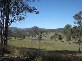
Nindooinbah is a rural locality in the Scenic Rim Region, Queensland, Australia. In the 2021 census, Nindooinbah had a population of 95 people.

The Shire of Tamborine was a local government area in South East Queensland, Australia, centred on the village of Tamborine. It existed from 1890 to 1949.

Witheren is a rural locality in the Scenic Rim Region, Queensland, Australia. In the 2021 census, Witheren had a population of 581 people.

<span class="mw-page-title-main">Biddaddaba, Queensland</span> Suburb of Scenic Rim Region, Queensland, Australia

Biddaddaba is a rural locality in the Scenic Rim Region, Queensland, Australia. In the 2021 census, Biddaddaba had a population of 171 people.

<span class="mw-page-title-main">Boyland, Queensland</span> Suburb of Scenic Rim Region, Queensland, Australia

Boyland is a rural locality in the Scenic Rim Region, Queensland, Australia. In the 2021 census, Boyland had a population of 855 people.

<span class="mw-page-title-main">Illinbah, Queensland</span> Suburb of Scenic Rim Region, Queensland, Australia

Illinbah is a rural locality in the Scenic Rim Region, Queensland, Australia. In the 2021 census, Illinbah had a population of 128 people.

<span class="mw-page-title-main">Kerry, Queensland</span> Town in Queensland, Australia

Kerry is a rural locality in the Scenic Rim Region, Queensland, Australia. In the 2016 census, Kerry had a population of 326 people.

<span class="mw-page-title-main">Mount Nathan, Queensland</span> Suburb of City of Gold Coast, Queensland, Australia

Mount Nathan is a rural locality in the City of Gold Coast, Queensland, Australia. In the 2021 census, Mount Nathan had a population of 1,375 people.

<span class="mw-page-title-main">Tamborine, Queensland</span> Town in Queensland, Australia

Tamborine is a rural town in the Scenic Rim Region and a locality split between the Scenic Rim Region and the City of Logan in Queensland, Australia. In the 2016 census, the locality of Tamborine had a population of 3,950 people.

<span class="mw-page-title-main">O'Reilly, Queensland</span> Suburb of Scenic Rim Region, Queensland, Australia

O'Reilly is a rural locality in the Scenic Rim Region, Queensland, Australia. It borders New South Wales. In the 2021 census, O'Reilly had a population of 114 people.

<span class="mw-page-title-main">Tabragalba, Queensland</span> Suburb of Scenic Rim Region, Queensland, Australia

Tabragalba is a rural locality in the Scenic Rim Region of South East Queensland, Australia. In the 2021 census, Tabragalba had a population of 48 people.

<span class="mw-page-title-main">Wonglepong QCWA Hall</span> Historic site in Queensland, Australia

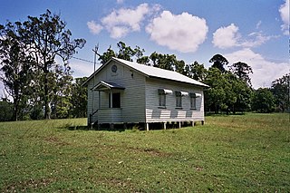
Wonglepong QCWA Hall is a heritage-listed community hall at 2779 Beaudesert-Nerang Road, Wonglepong, Scenic Rim Region, Queensland, Australia. It was built in 1935 by EJ Franklin. It was added to the Queensland Heritage Register on 11 November 2005.

<span class="mw-page-title-main">Flying Fox, Queensland</span> Suburb of Scenic Rim Region, Queensland, Australia

Flying Fox is a rural locality in the Scenic Rim Region, Queensland, Australia. In the 2021 census, Flying Fox had a population of 61 people.

<span class="mw-page-title-main">Cainbable, Queensland</span> Suburb of Scenic Rim Region, Queensland, Australia

Cainbable is a rural locality in the Scenic Rim Region, Queensland, Australia. In the 2021 census, Cainbable had a population of 85 people.

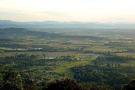
The Tamborine Mountain road network is a group of roads that provide access to the mountain community from various lowland localities. The network ensures continuity of access in times of flooding or other natural disasters, and during planned maintenance activities. The locality of Tamborine Mountain includes a plateau that hosts a substantial residential community plus many tourism accommodation and activity venues.

References

  1. 1 2 3 Australian Bureau of Statistics (28 June 2022). "Wonglepong (SAL)". 2021 Census QuickStats. Retrieved 28 February 2023. OOjs UI icon edit-ltr-progressive.svg
  2. 1 2 "Wonglepong – locality in Scenic Rim Region (entry 45208)". Queensland Place Names. Queensland Government . Retrieved 29 December 2020.
  3. 1 2 "Tamborine" (Map). Queensland Government. 1926. Archived from the original on 5 April 2020. Retrieved 7 September 2022.
  4. "OBITUARY". The Beaudesert Times . Vol. XXXIII, no. 1679. Queensland, Australia. 4 October 1940. p. 7. Archived from the original on 7 September 2022. Retrieved 7 September 2022 via National Library of Australia.
  5. "Series ID5962, Wonglepong Cemetery Register of Graves - Beaudesert Shire Council / Tamborine Shire Council". Queensland State Archives . Retrieved 7 September 2022.
  6. Queensland Family History Society (2010), Queensland schools past and present (Version 1.01 ed.), Queensland Family History Society, ISBN   978-1-921171-26-0
  7. "Agency ID 8931, Wonglepong State School: Description". Queensland State Archives . Retrieved 7 September 2022.
  8. "Parish of Tabragalba" (Map). Queensland Government. 1931. Archived from the original on 7 September 2022. Retrieved 7 September 2022.
  9. "Caningera School". Monument Australia. Archived from the original on 23 April 2022. Retrieved 7 September 2022.
  10. Blake, Thom. "Wonglepong Methodist Church". Queensland religious places database. Archived from the original on 7 September 2022. Retrieved 7 September 2022.
  11. "New Methodist". The Beaudesert Times . Vol. XLVI, no. 2387. Queensland, Australia. 28 May 1954. p. 3. Archived from the original on 6 September 2022. Retrieved 7 September 2022 via National Library of Australia.
  12. "Tamborine" (Map). Queensland Government. 1954. Archived from the original on 2 April 2020. Retrieved 4 July 2020.
  13. "6 State Branch Railway lines To Be Closed". Townsville Daily Bulletin . Vol. LXXV. Queensland, Australia. 15 January 1955. p. 1. Retrieved 8 June 2024 via National Library of Australia.
  14. "Wonglepong QCWA Hall (entry 602549)". Queensland Heritage Register . Queensland Heritage Council. Retrieved 1 August 2014.
  15. "WONGLEPONG". The Beaudesert Times . Vol. XXVIII, no. 1429. Queensland, Australia. 1 November 1935. p. 5. Archived from the original on 7 September 2022. Retrieved 7 September 2022 via National Library of Australia.
  16. "The Social Round". The Telegraph . Queensland, Australia. 5 December 1935. p. 16 (LATE CITY). Archived from the original on 7 September 2022. Retrieved 7 September 2022 via National Library of Australia.
  17. Schaefer, Tim (29 October 2015). "Wonglepong CWA to celebrate 90th anniversary". Beaudesert Times. Archived from the original on 7 September 2022. Retrieved 7 September 2022.
  18. Australian Bureau of Statistics (31 October 2012). "Wonglepong (State Suburb)". 2011 Census QuickStats. Retrieved 14 July 2013. OOjs UI icon edit-ltr-progressive.svg
  19. Australian Bureau of Statistics (27 June 2017). "Wonglepong (SSC)". 2016 Census QuickStats. Retrieved 20 October 2018. OOjs UI icon edit-ltr-progressive.svg
  20. "Wonglepong QCWA Hall (entry 602549)". Queensland Heritage Register . Queensland Heritage Council. Retrieved 12 July 2013.
  21. "Queensland Globe". State of Queensland . Retrieved 7 September 2022.
  22. "Branch Locations". Queensland Country Women's Association. Archived from the original on 26 December 2018. Retrieved 26 December 2018.
  23. 1 2 "Land for public recreation - Queensland". Queensland Open Data. Queensland Government. 20 November 2020. Archived from the original on 22 November 2020. Retrieved 22 November 2020.
  24. "Cemetery Areas - Queensland". Queensland Open Data. Queensland Government. 12 November 2020. Archived from the original on 15 November 2020. Retrieved 12 November 2020.
  25. "Cemetery Locations". Scenic Rim Regional Council. Archived from the original on 6 April 2022. Retrieved 7 September 2022.

Commons-logo.svg Media related to Wonglepong, Queensland at Wikimedia Commons