Barney View, Queensland

Last updated

Barney View
Queensland
MtMaroon.jpg
Australia Queensland location map.svg
Red pog.svg
Barney View
Coordinates 28°14′15″S152°45′52″E / 28.2375°S 152.7644°E / -28.2375; 152.7644 Coordinates: 28°14′15″S152°45′52″E / 28.2375°S 152.7644°E / -28.2375; 152.7644
Population64 (2016 census) [1]
 • Density1.744/km2 (4.52/sq mi)
Postcode(s) 4287
Area36.7 km2 (14.2 sq mi)
Time zone AEST (UTC+10:00)
LGA(s) Scenic Rim Region
State electorate(s) Scenic Rim
Federal division(s) Wright
Suburbs around Barney View:
Maroon Rathdowney Rathdowney
Maroon Barney View Palen Creek
Maroon Mount Barney
Palen Creek
Palen Creek

Barney View is a rural locality in the Scenic Rim Region, Queensland, Australia. [2] In the 2016 census, Barney View had a population of 64 people. [1]

Contents

Geography

Mount Maroon rises to 966 metres (3,169 ft) above sea level in the west of Barney View. This western section is protected within Mount Barney National Park. The upper Logan River passes through the west of the locality and marks a portion of the western border. In the south the terrain rises to more than 500 metres (1,600 ft) along the northern slopes of Mount Giles. The privately operated Flanagan Reserve Bush Camping allows visitors to camp at a 12-hectare (30-acre) site along the river.[ citation needed ]

History

Uniting Church, Barney View, 2006 Methodist (now Uniting) Church, Barney View, 2006.JPG
Uniting Church, Barney View, 2006

Barney View was originally known as Thulimbah, which was frequently confused with another Queensland district of the same name, Thulimbah near Stanthorpe. The problem was resolved in 1916 by changing the name to Barney View (due to its location beside Mount Barney). [3]

Thulimbah Methodist Church was opened free of debt on 14 June 1908; it was built from timber sourced from local trees. It was renamed Barney View Methodist Church when the district's name changed. Following the amalgamation of the Methodist Church into the Uniting Church in Australia in 1977, it became Barney View United Church. [4] On 6 November 2016 it closed as a Uniting church closed and was leased to the community as Barney View Community Church. [5] [6] [7]

Barney View Lutheran church was dedicated on Wednesday 16 November 1910 with sermons in both German and English. [8] The church closed in 1966. [4] In the 1970s the church building was relocated to Rathdowney to extend the Rathdowney Methodist (later Uniting) Church. [9] The Lutheran Church still owns the land on Barney View Road (now just within the boundaries of Palen Creek, 28°16′02″S152°47′18″E / 28.2672°S 152.7884°E / -28.2672; 152.7884 (Abode Park) ) and operates it as a campsite called Abode Park. It is named after Pastor Armin Bode who was a Lutheran minister in the Parish of Teviotville (which included Barney View) from 1915 to 1969. [4] [10] [11] A memorial at the park commemorates the former church. [4]

Following the closure of the Readville (Widgee Creek) State School in 1911, it was decided in April 1918 to relocate the building to establish a school at Barney View. [12] Barney View State School opened on 4 October 1918. It had a temporary closure from 1938 to circa 1941 due to low student numbers. It closed permanently in March 1961. [13] [14] It was located on a bend in the Mount Barney Road ( 28°14′28″S152°45′54″E / 28.2412°S 152.7651°E / -28.2412; 152.7651 (Mount Barney State School) ). [15] [16]

Heritage listings

Heritage-listed sites at Barney View include:

Demographics

Barney View has a population of 64 at the 2016 census. The locality contains 32 households, in which 45.9% of the population are males and 54.1% of the population are females with a median age of 54, 16 years above the national average. The average weekly household income is $833, $605 below the national average. [1]

Amenities

Barney View Community Church is on Mount Barney Road ( 28°14′30″S152°46′06″E / 28.2417°S 152.7684°E / -28.2417; 152.7684 (Barney View Community Church) ). [7]

Related Research Articles

Rathdowney, Queensland Town in Queensland, Australia

Rathdowney is a rural town and locality in the Scenic Rim Region, Queensland, Australia. In the 2016 census, Rathdowney had a population of 308 people.

Beaudesert, Queensland Town in Queensland, Australia

Beaudesert is a rural town and locality in the Scenic Rim Region, Queensland, Australia. In the 2016 census, Beaudesert had a population of 6,395 people.

Logan River

The Logan River is a perennial river located in the Scenic Rim, Logan and Gold Coast local government areas of the South East region of Queensland, Australia. The 184-kilometre (114 mi)-long river is one of the dominant waterways in South East Queensland that drains the southern ranges of the Scenic Rim and empties into Moreton Bay after navigating the City of Logan, a major suburban centre located south of Brisbane. The catchment is dominated by urban and agricultural land use. Near the river mouth are mangrove forests and a number of aquaculture farms.

Boonah, Queensland Town in Queensland, Australia

Boonah is a rural town and locality in the Scenic Rim Region, Queensland, Australia. In the 2016 census the locality of Boonah had a population of 2,484 people.

Mount Lindesay (Queensland) Suburb of Scenic Rim Region, Queensland, Australia

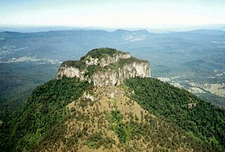
Mount Lindesay is a rural locality in the Scenic Rim Region, Queensland, Australia. It borders New South Wales. In the 2016 census, Mount Lindesay had a population of 3 people.

Canungra, Queensland Town in Queensland, Australia

Canungra is a rural town and locality in the Scenic Rim Region, Queensland, Australia. In the 2016 census the locality of Canungra had a population of 1,229 people.

Scenic Rim Region Local government area in Queensland, Australia

The Scenic Rim Region is a local government area in West Moreton region of South East Queensland, Australia. Established in 2008, it was preceded by several previous local government areas with histories extending back to the early 1900s and beyond. The main town of the region is Beaudesert.

Kalbar, Queensland Town in Queensland, Australia

Kalbar is a rural town and locality in the Scenic Rim Region, Queensland, Australia. In the 2016 census, Kalbar had a population of 1,093 people.

Dugandan, Queensland Suburb of Boonah, Queensland, Australia

Dugandan is a rural town and locality in the Scenic Rim Region, Queensland, Australia. In the 2016 census, Dugandan had a population of 593 people.

Beaudesert Shire Tramway Former tramway in Queensland, Australia

The Beaudesert Shire Tramway was a narrow gauge tramway which operated from Beaudesert to Lamington and Rathdowney in the Scenic Rim Region, Queensland, Australia, It was one of 15 light railways built and operated by Divisional Boards and Shire Councils in Queensland. The line carried passengers and cargo. It operated from 1903 to 1944. It was initially profitable and seen as a great success for the local shire council. The tramway is credited with opening up the agricultural lands of the upper Logan River.

Maroon, Queensland Town in Queensland, Australia

Maroon is a rural locality in the Scenic Rim Region, Queensland, Australia. In the 2016 census, Maroon had a population of 149 people.

Tamrookum, Queensland Suburb of Scenic Rim Region, Queensland, Australia

Tamrookum is a rural locality in the Scenic Rim Region, Queensland, Australia. In the 2016 census, Tamrookum had a population of 91 people.

Harrisville, Queensland Town in Queensland, Australia

Harrisville is a rural town and locality in the Scenic Rim Region, Queensland, Australia. In the 2016 census the locality of Harrisville had a population of 613 people.

Veresdale, Queensland Suburb of Logan City, Queensland, Australia

Veresdale is a locality split between the City of Logan and the Scenic Rim Region, Queensland, Australia. In the 2016 census Veresdale had a population of 392 people.

Mount Alford, Queensland Town in Queensland, Australia

Mount Alford is a rural town and locality in the Scenic Rim Region, Queensland, Australia. In the 2016 census the locality of Mount Alford had a population of 268 people.

Palen Creek, Queensland Suburb of Scenic Rim Region, Queensland, Australia

Palen Creek is a rural locality in the Scenic Rim Region, Queensland, Australia. It borders New South Wales. In the 2016 census, Palen Creek had a population of 280 people.

Oaky Creek, Queensland Suburb of Scenic Rim Region, Queensland, Australia

Oaky Creek is a rural locality in the Scenic Rim Region, Queensland, Australia. In the 2016 census Oaky Creek had a population of 83 people.

Running Creek, Queensland Suburb of Scenic Rim Region, Queensland, Australia

Running Creek is a rural locality in the Scenic Rim Region, Queensland, Australia. In the 2016 census Running Creek had a population of 147 people. It borders New South Wales.

Burnett Creek, Queensland Suburb of Scenic Rim Region, Queensland, Australia

Burnett Creek is a rural locality in the Scenic Rim Region, Queensland, Australia. In the 2016 census Burnett Creek had a population of 11 people. It borders New South Wales to the south.

Ipswich–Boonah–Rathdowney Road is a continuous 87.8 kilometres (54.6 mi) road route in the Ipswich and Scenic Rim regions of Queensland, Australia. It has two official names, Ipswich – Boonah Road and Boonah – Rathdowney Road. The entire route is signed as State Route 93, and much of it is also part of Tourist Drive 16.

References

  1. 1 2 3 Australian Bureau of Statistics (27 June 2017). "Barney View (SSC)". 2016 Census QuickStats. Retrieved 20 October 2018. OOjs UI icon edit-ltr-progressive.svg
  2. "Barney View – locality in Scenic Rim Region (entry 45108)". Queensland Place Names. Queensland Government . Retrieved 5 November 2019.
  3. "Heart of the Scenic Rim" (PDF). Boonah Tourism. Archived from the original (PDF) on 13 January 2020. Retrieved 12 September 2021.
  4. 1 2 3 4 Boonah Shire Council. "Heart of the Scenic Rim" (PDF). Scenic Rim Regional Council. p. 28. Archived (PDF) from the original on 17 February 2017. Retrieved 18 September 2020.
  5. Schaefer, Timothy (29 October 2016). "Barney View church gets a new lease of life". Queensland Country Life. Archived from the original on 29 October 2016. Retrieved 12 September 2021.
  6. Schaefer, Timothy (10 November 2016). "Barney View church handed back to the community". Beaudesert Times. Archived from the original on 12 September 2021. Retrieved 12 September 2021.
  7. 1 2 "Barney View Uniting Church". Churches Australia. Archived from the original on 12 September 2021. Retrieved 12 September 2021.
  8. "Advertising". The Beaudesert Times . 3 (110). Queensland, Australia. 11 November 1910. p. 3. Archived from the original on 12 September 2021. Retrieved 19 September 2020 via National Library of Australia.
  9. Marschke, Tanya (26 February 2014). "Rathdowney worshipers say final prayers at Uniting Church". Beaudesert Times. Archived from the original on 18 September 2020. Retrieved 18 September 2020.
  10. "Abode Park". Lutheran Youth of Queensland. Archived from the original on 18 September 2020. Retrieved 19 September 2020.
  11. Bode, Armin, Pastor Armin Bode Papers, ca. 1890s-1994, State Library of Queensland, archived from the original on 12 September 2021, retrieved 19 September 2020
  12. "Barney View State School". The Beaudesert Times . Queensland, Australia. 5 April 1918. p. 2. Archived from the original on 12 September 2021. Retrieved 30 April 2020 via Trove.
  13. Queensland Family History Society (2010), Queensland schools past and present (Version 1.01 ed.), Queensland Family History Society, ISBN   978-1-921171-26-0
  14. "Opening and closing dates of Queensland Schools". Queensland Government . Retrieved 18 April 2019.
  15. "Dugandan" (Map). Queensland Government. 1935. Archived from the original on 30 May 2020. Retrieved 30 April 2020.
  16. "Queensland Globe". State of Queensland . Retrieved 12 August 2021.
  17. "Local Heritage Register" (PDF). Scenic Rim Regional Council. Archived from the original (PDF) on 24 September 2015. Retrieved 9 February 2015.