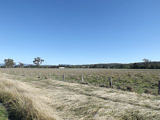
Beaudesert is a rural town and locality in the Scenic Rim Region, Queensland, Australia. It is south of Brisbane and west of Gold Coast. In the 2016 census, Beaudesert had a population of 6,395 people.

Natural Bridge is a rural locality in the City of Gold Coast, Queensland, Australia. In the 2016 census, Natural Bridge had a population of 108 people.

Binna Burra is a parcel of private land and mountain lodge surrounded by Lamington National Park in Queensland, Australia. It is also a locality in the Scenic Rim Region. The lodge lies in the north-eastern corner of the Lamington Plateau in the McPherson Range, 75 kilometres (47 mi) south of Brisbane. It is marketed as an ecolodge and was one of the first nature based resorts to be established in Australia. In 2000, the resort was the first commercial accommodation provider to be awarded Green Globe Certification in Australia. The lodge and other aspects of the built environment at Binna Burra are listed on the Queensland Heritage Register as the Binna Burra Cultural Landscape. In September 2019, the area was devastated by bushfires and the historic lodge was destroyed.

Canungra is a small rural town and locality in the Scenic Rim Region, Queensland, Australia. At the 2016 census, Canungra had a population of 1229.

The Scenic Rim is a group of forested mountain ranges of the Great Dividing Range, located south of Brisbane agglomeration, straddling the border between south-eastern Queensland and north-eastern New South Wales, Australia.

Numinbah Valley is a rural locality in the City of Gold Coast, Queensland, Australia. In the 2016 census, Numinbah Valley had a population of 218 people.

The Scenic Rim Region is a local government area in West Moreton region of South East Queensland, Australia. Established in 2008, it was preceded by several previous local government areas with histories extending back to the early 1900s and beyond. The main town of the region is Beaudesert.

Beechmont is a rural town and locality in the Scenic Rim Region, Queensland, Australia. In the 2016 census, Beechmont had a population of 842 people.

Tamrookum is a rural locality in the Scenic Rim Region, Queensland, Australia. In the 2016 census, Tamrookum had a population of 91 people.

O'Reilly is a locality in the Scenic Rim Region, Queensland, Australia. It is located on border between Queensland and New South Wales on the elevated Lamington Plateau. The plateau remains heavily vegetated by Gondwana Rainforests within the Lamington National Park which covers almost all of O'Reilly. The park contains a network of walking tracks, lookouts and numerous waterfalls. The mountain resort known as O'Reilly's Rainforest Retreat is a popular attraction.

Darlington is a locality in the Scenic Rim Region of South East Queensland, Australia.

Tabooba is a locality in the Scenic Rim Region of South East Queensland, Australia.

Lamington is a rural locality in the Scenic Rim Region, Queensland, Australia. In the 2016 census, Lamington and surrounding localities had a population of 86 people.

Cannon Creek is a locality in the Scenic Rim Region, Queensland, Australia.

Cainbable is a locality in the Scenic Rim Region, Queensland, Australia.

Morwincha is a locality in the Scenic Rim Region, Queensland, Australia.

Radford is a locality in the Scenic Rim Region, Queensland, Australia.

Sarabah is a locality in the Scenic Rim Region, Queensland, Australia.

Wallaces Creek is a locality in the Scenic Rim Region, Queensland, Australia.

The Head is a rural locality in the Southern Downs Region, Queensland, Australia. In the 2016 census, The Head had a population of 7 people.


