Moogerah Dam

Last updated

Moogerah Dam
Lake Moogerah dam wall.jpg
The Moogerah Dam wall, in 2011
Australia Queensland relief location map.jpg
Red pog.svg
Location of the Moogerah Dam
in Queensland
CountryAustralia
Location South East Queensland
Coordinates 28°1′48″S152°32′56″E / 28.03000°S 152.54889°E / -28.03000; 152.54889 Coordinates: 28°1′48″S152°32′56″E / 28.03000°S 152.54889°E / -28.03000; 152.54889
Purpose
StatusOperational
Construction began1959 (1959)
Opening date1961 (1961)
Operator(s) SEQ Water
Dam and spillways
Type of dam Arch dam
ImpoundsReynolds Creek
Height38 m (125 ft) [1]
Length219 m (719 ft) [1] [2]
Dam volume23×10^3 m3 (810×10^3 cu ft) [1]
Spillway type Uncontrolled
Spillway capacity740 m3/s (26,000 cu ft/s) [1]
Reservoir
CreatesLake Moogerah
Total capacity83,700 ML (1.84×10¹⁰ imp gal; 2.21×10¹⁰ US gal) [2] [3]
Catchment area 228 km2 (88 sq mi) [1] [2]
Surface area827 ha (2,040 acres) [2] [3]
Normal elevation154.91 m (508.2 ft) AHD
Website
www.seqwater.com.au

The Moogerah Dam is a mass concrete double curvature arch dam with an un-gated spillway across the Reynolds Creek that is located in the South East region of Queensland, Australia. The main purposes of the dam are for irrigation of the Reynolds Creek and for supply of potable water to Warrill Creek and farmers in the Warrill Valley. [1] [3] The impounded reservoir is called Lake Moogerah.

Contents

Moogerah is derived from the Aboriginal word Moojirah, meaning "home of the thunderstorm."[ citation needed ]

Location and features

Spillway Lake Moogerah spillway.jpg
Spillway

The dam is located above the Fassifern Valley, approximately 60 kilometres (37 mi) southwest of Ipswich. Aratula is the nearest town, approximately 11 kilometres (6.8 mi) from the dam and the nearest major centre is Boonah. The primary inflow of the reservoir is the Reynolds Creek, a tributary of the Bremer River. [3]

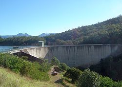
Construction on the dam began in 1959, although land for the project was resumed as early as 1916. [4] Completed in 1961 as the central catchment of the Warrill Valley Water Supply Scheme, the concrete dam structure is 38 metres (125 ft) high and 219 metres (719 ft) long and allows access to Mount Edwards in Moogerah Peaks National Park. The 315-thousand-cubic-metre (11.1×10^6 cu ft) dam wall holds back the 83,765-megalitre (1.8426×10¹⁰ imp gal; 2.2128×10¹⁰ US gal) reservoir when at full capacity. From a catchment area of 228 square kilometres (88 sq mi) that includes much of the northeastern slopes of the Main Range, the dam creates Lake Moogerah, with a surface area of 827 hectares (2,040 acres). The uncontrolled spillway has a discharge capacity of 740 cubic metres per second (26,000 cu ft/s). [1] Initially managed by SunWater, management of the dam was transferred to Seqwater in July 2008 as part of a water security project in the South East Queensland region, known as the South East Queensland Water Grid. [5]

The dam supplies drinking water to the towns of Boonah and Ipswich, although the main user is the Swanbank Power Station. It also supplies irrigation water to small crop farms in the Fassifern Valley. SunWater is undertaking a dam spillway capacity upgrade program to ensure the continued safety of the dam. [6] During the 1995 drought dam levels declined to a low of 1% total capacity. [7] The dam reached 100% capacity due to rainfall associated with the 2010–2011 Queensland floods, with water flowing over the spillway for the first time since 1991 on 6 December 2010. [8] [9]

Recreation

Lake Moogerah at 99.5% capacity Lake Moogerah 6.jpg
Lake Moogerah at 99.5% capacity

Amenities adjacent to the dam and reservoir include such places as Moogerah Lakeside Bush Retreat which was previously a church campground but is now a locally owned and operated lakeside camping destination offering standard camping options as well as bunkhouses sleeping up to 12 people each, and self-contained cottage accommodation. Activities available at the retreat include fishing, boat hire, kayak hire, as well as a variety of bushwalks.

In addition to this, Camp Moogerah is on the eastern shore of the lake, offering cabin accommodation and outdoor activity camps for schools, churches, youth groups, sports clubs etc. [10] On the western shore are School Camps Queensland and Camp Laurence which offer group accommodation camps with educational and adventure activities for school students, family and church groups. On the southern shore is the privately owned and used, Brisbane Grammar School Pepperina Hill Campsite, which is primarily used for grade 8-10 camps throughout the year, and where the school owns a boatshed for kayaking on the lake.

Barbecues and picnic areas at Haig Park. This side also provides access to the dam wall. Across the wall is Mount Edwards which has several walking trail and hiking paths. The road uphill behind the old kiosk (now a house) leads to a lookout and downhill to a further picnic area and playground at the bottom of the wall on the banks of Reynolds Creek.

School Camps Queensland operates camping and family cabins that sleep up to 12 people in each cabin during school holidays and weekends. Scenic Rim Regional Council operate a caravan park at the end of Muller Park road. It offers a variety of accommodation (powered, unpowered tent and caravan sites, overnight cabin and house and permanent cabins). Other site facilities include electric and wood barbecues, two boat ramps, kiosk (bread, milk, ice, firewood and sundries), kayak hire and children's playground. Lake Moogerah Caravan Park is located near many of the area's attractions and activities, including wineries, national parks and Lake Moogerah itself.

In September 2014 a designated swimming area at A G Muller Park was opened to the public. [11] Lake Moogerah is extremely popular for waterskiing and plays host to jetski and waterskiing events throughout the year.

A stocked impoundment permit is required to fish in the dam. [12] Permits are available from the manager at Lake Moogerah Caravan Park.

Events

The Moogerah Passion Play is an open-air theatre production on the shores of Lake Moogerah. It is held every Easter, with a cast of up to 80. [13]

See also

Related Research Articles

Somerset Dam Dam in South East Queensland

The Somerset Dam is a mass concrete gravity dam with a gated spillway across the Stanley River in Queensland, Australia. It is within the locality of Somerset Dam in the Somerset Region in South East Queensland. The main purpose of the dam is the supply of potable water for the Brisbane, Gold Coast and Logan City regions. Additionally, the dam provides for flood mitigation, recreation and for the generation of hydroelectricity. The impounded reservoir is called Lake Somerset.

Hinze Dam Dam in South East Queensland

The Hinze Dam is a rock and earth-fill embankment dam with an un-gated spillway across the Nerang River in the Gold Coast hinterland of South East, Queensland, Australia. The main purpose of the dam is for potable water supply of the Gold Coast region. The impounded reservoir is called Advancetown Lake.

Leslie Harrison Dam Dam in South East Queensland

The Leslie Harrison Dam is an earth-fill embankment dam across the Tingalpa Creek that is located in the South East region of Queensland, Australia.The main purpose of the dam is for potable water supply of the Redland City in Brisbane. The impounded reservoir is called Tingalpa Reservoir. The dam was named after Robert Leslie Harrison, a Queensland parliamentarian who died in April 1966.

Maroon Dam Dam in South East Queensland

The Maroon Dam is a rock and earth-fill embankment dam with an un-gated spillway across the Burnett Creek that is located in the South East region of Queensland, Australia. The main purpose of the dam is for irrigation of the Scenic Rim Regional Council region. The impounded reservoir is also called Maroon Dam.

North Pine Dam Dam in South East Queensland

The North Pine Dam is a mass concrete gravity dam with earth-fill embankments on abutments with a gated spillway across the North Pine River that is located in the South East region of Queensland, Australia. The main purpose of the dam is for supply of potable water for the Moreton Bay region and Brisbane's northern suburbs. The impounded reservoir is called Lake Samsonvale.

Little Nerang Dam Dam in South East Queensland

The Little Nerang Dam is a concrete gravity dam with an un-gated spillway across the Little Nerang Creek that is located in the South East region of Queensland, Australia. The main purpose of the dam is for potable water supply of the Gold Coast region. The impounded reservoir is also called Little Nerang Dam. The dam was closed to the public in 2013 due to safety concerns.

Lake Narracan Dam in Gippsland, Victoria (near Newborough)"`UNIQ--ref-00000001-QINU`"

Lake Narracan is an artificial lake on the Latrobe River built to supply cooling water for the nearby brown coal-fired power stations.

Sideling Creek Dam Dam in South East Queensland

The Sideling Creek Dam is an earth-fill embankment dam with an un-gated spillway across the Sideling Creek that is located in the South East region of Queensland, Australia. The main purposes of the dam are for potable water supply of the Moreton Bay region and for recreation. The impounded reservoir is called Lake Kurwongbah.

Atkinson Dam Dam in South East Queensland

The Atkinson Dam is an earth-fill embankment dam across the Buaraba Creek and a naturally forming lagoon, which is located near Lowood in the South East region of Queensland, Australia. The main purpose of the dam is for irrigation of farming land in the lower Lockyer Valley. The resultant reservoir is called Lake Atkinson.

Borumba Dam Dam in Wide Bay–Burnett, Queensland

The Borumba Dam is a rock-fill embankment dam with an un-gated spillway located across the Yabba Creek in the Wide Bay–Burnett region of Queensland, Australia. The main purposes of the dam are for irrigation and potable water supply. The resultant impounded reservoir is called Lake Borumba.

Bjelke-Petersen Dam

Construction of Bjelke-Petersen Dam near Cherbourg in Queensland, commenced in 1984 and finished in 1988. It created the lake that was named Lake Barambah after the original property in the region. The dam supplies water to the South Burnett region, mostly for irrigation purposes.

Wappa Dam Dam in South East Queensland

The Wappa Dam is a mass concrete gravity arch dam with earth-fill abutments and an un-gated spillway across the South Maroochy River that is located in the South East region of Queensland, Australia. The main purpose of the dam is for supply of potable water for the Sunshine Coast region. The impounded reservoir is also called Wappa Dam. The dam and most of the reservoir are within Kiamba with the most northerly part of the reservoir in Cooloolabin, both in the Sunshine Coast Region.

Bill Gunn Dam Dam in South East Queensland

The Bill Gunn Dam is an earth-fill embankment dam with an un-gated spillway located off-stream in Laidley Heights in the South East region of Queensland, Australia. The main purpose of the dam is for irrigation of the Lockyer Valley. The resultant reservoir is called Lake Dyer.

Lake Clarendon Dam Dam in South East Queensland

The Lake Clarendon Dam is a rock and earth-fill embankment dam with an un-gated spillway located off-stream in the locality of Lake Clarendon in the Lockyer Valley Region, South East Queensland, Australia. The main purpose of the dam is for irrigation of the Lockyer Valley. The resultant impounded reservoir is called Lake Clarendon.

Ewen Maddock Dam Dam in South East Queensland

The Ewen Maddock Dam is an earth-fill embankment dam with an un-gated spillway across the Addlington Creek that is located in the South East region of Queensland, Australia. The main purpose of the dam is for potable water supply of the Sunshine Coast region.

Baroon Pocket Dam Dam in South East Queensland

The Baroon Pocket Dam is a rock and earth-fill embankment dam with an un-gated spillway across the Obi Obi Creek, in North Maleny, Sunshine Coast Region, in South East Queensland, Australia. The main purpose of the dam is for potable water supply. The impounded reservoir is called Lake Baroon.

Cedar Pocket Dam Dam in Wide Bay–Burnett, Queensland

The Cedar Pocket Dam is a partially concrete gravity and rock and earth-fill embankment dam with an un-gated spillway located across the Deep Creek in the Wide Bay–Burnett region of Queensland, Australia. The main purpose of the dam is for irrigation, where the dam provides regulated water supplies along Deep Creek, a tributary of the Mary River.

Coolmunda Dam Dam in Coolmunda, Goondiwindi Region

The Coolmunda Dam is an earth–fill embankment dam with a gated spillway across the Macintrye Brook, a tributary of the Dumaresq River, that is located on Darling Downs in Queensland, Australia. The main purposes of the dam are for irrigation and potable water supply. The impounded reservoir is called the Lake Coolmunda.

Lake Manchester Dam Dam in South East Queensland

The Lake Manchester Dam is a concrete gravity dam with an un-gated spillway across the Cabbage Tree Creek that is located in the South East region of Queensland, Australia. The main purpose of the dam is for potable water supply of Brisbane. The impounded reservoir is called Lake Manchester.

Six Mile Creek Dam Dam in South East Queensland

The Six Mile Creek Dam is a rock and earth-fill embankment dam with an un-gated spillway across the Six Mile Creek that is located in the South East region of Queensland, Australia. The main purposes of the dam are for potable water supply of the Sunshine Coast region and for recreation. The impounded reservoir is called Lake Macdonald.

References

  1. 1 2 3 4 5 6 7 8 "Register of Large Dams in Australia" (Excel (requires download)). Dams information. Australian National Committee on Large Dams. 2010. Retrieved 4 July 2014.
  2. 1 2 3 4 "Moogerah Dam". Water supply: Dams and weirs. Seqwater. 2014. Retrieved 4 July 2014.
  3. 1 2 3 4 Harrison, Rod; James, Ernie; Sully, Chris; Classon, Bill; Eckermann, Joy (2008). Queensland Dams. Bayswater, Victoria: Australian Fishing Network. ISBN   978-1-86513-134-4.
  4. Heritage Trails of the Great South East. Queensland Environmental Protection Agency. State of Queensland. 2000. p. 32. ISBN   0-7345-1008-X.
  5. Hurst, Daniel (7 July 2009). "Water funds slash debt". The Bayside Bulletin. Retrieved 21 April 2008.
  6. Spillway Capacity Upgrade Program Archived 13 February 2008 at the Wayback Machine
  7. Collie, Gordon. Worst drought of century cripples farmers. The Courier Mail. 26 August 1995.
  8. Queensland Seqwater Dam Level listing Archived 14 October 2012 at the Wayback Machine
  9. News Page of the Lake Moogerah Caravan Park Archived 24 February 2011 at the Wayback Machine
  10. Camp Moogerah, Outdoor Education, Sports Centre, School Camps And Youth Camps.
  11. "Designated swimming area opened at Lake Moogerah". Seqwater. 19 September 2014. Archived from the original on 3 March 2015. Retrieved 23 September 2014.
  12. "Do I need a permit to go fishing in a dam?". Department of Agriculture, Fisheries and Forestry. Queensland Government. 5 February 2013. Archived from the original on 4 July 2014. Retrieved 4 July 2014.
  13. Moogerah Passion Play