The Brisbane River is the longest river in South East Queensland, Australia, and flows through the city of Brisbane, before emptying into Moreton Bay on the Coral Sea. John Oxley, the first European to explore the river, named it after the Governor of New South Wales, Sir Thomas Brisbane in 1823. The penal colony of Moreton Bay later adopted the same name, eventually becoming the present city of Brisbane. The river is a tidal estuary and the water is brackish from its mouth through the majority of the Brisbane metropolitan area westward to the Mount Crosby Weir. The river is wide and navigable throughout the Brisbane metropolitan area.

Yarraman is a rural town and locality in the Toowoomba Region, Queensland, Australia. In the 2021 census, the locality of Yarraman had a population of 1,127 people.
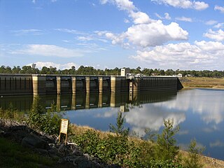
The North Pine Dam is a mass concrete gravity dam with earth-fill embankments on abutments with a gated spillway across the North Pine River that is located in the South East region of Queensland, Australia. The main purpose of the dam is for supply of potable water for the Moreton Bay region and Brisbane's northern suburbs. The impounded reservoir is called Lake Samsonvale.
Blackbutt is a rural town and locality in the South Burnett Region, Queensland, Australia. In the 2016 census, Blackbutt had a population of 836 people.
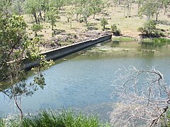
Meandu Creek Dam is a dam built near Yarraman in Queensland, Australia. The Tarong and Tarong North Power Stations source water from the Brisbane River catchment via a pipeline from Wivenhoe Dam. Cooling tower blowdown water is either discharged directly to Tarong Energy's Meandu Creek Dam or supplied to the nearby Tarong Mine owned by Rio Tinto Coal Australia. Excess water from the mine is discharged back to Meandu Creek Dam. Releases from Meandu Creek Dam supply downstream irrigators on Meandu Creek. In 2019 Stanwell Corporation temporarily stopped discharges into the creek to allow downstream property owners to repair culverts.

Tingoora is a rural town and a locality in the South Burnett Region, Queensland, Australia.
The Mount Crosby Weir is a heritage-listed weir on the Brisbane River at Mount Crosby and Chuwar, both in City of Brisbane, Queensland, Australia. The project was instigated by John Petrie at the end of the 19th century. The town of Brisbane was expanding and seeking more reliable sources of drinking water than Enoggera Dam and Gold Creek Dam could provide. In conjunction with the Mount Crosby Pumping Station, it was listed on the Queensland Heritage Register on 25 October 2019.

Harlin is a rural town and locality in the Somerset Region, Queensland, Australia. In the 2016 census, the locality of Harlin had a population of 173 people.

Elgin Vale is a rural locality in the Gympie Region, Queensland, Australia. In the 2016 census, Elgin Vale had a population of 24 people.

Colinton is a rural locality in the Somerset Region, Queensland, Australia. In the 2016 census, Colinton had a population of 75 people.
Upper Yarraman is a rural locality in the Toowoomba Region, Queensland, Australia. In the 2016 census, Upper Yarraman had a population of 104 people.
The Kilkivan to Kingaroy Rail Trail is an 88-kilometre (55 mi) recreation trail from Kilkivan to Kingaroy. The trail follows the old Kingaroy Branch railway and is open to walkers, cyclists and horse riders.
Goodger is a rural locality in the South Burnett Region, Queensland, Australia. In the 2016 census Goodger had a population of 187 people.
Nukku is a rural locality in the South Burnett Region, Queensland, Australia. In the 2021 census Nukku had a population of 40 people.
Mount Stanley is a rural locality in the Somerset Region, Queensland, Australia. In the 2016 census Mount Stanley had a population of 7 people.
Gilla is a rural locality in the Toowoomba Region, Queensland, Australia. In the 2016 census Gilla had a population of 32 people.
Googa Creek is a rural locality in the Toowoomba Region, Queensland, Australia. In the 2016 census Googa Creek had a population of 43 people.
South Nanango is a rural locality in the South Burnett Region, Queensland, Australia. In the 2016 census South Nanango had a population of 858 people.
Emu Creek is a rural locality in the Toowoomba Region, Queensland, Australia. In the 2021 census, Emu Creek had a population of 113 people.
Bunya Mountains road network is a group of roads that provide access to the mountain community from various lowland localities. The network ensures continuity of access in times of flooding or other natural disasters, and during planned maintenance activities. The locality of Bunya Mountains includes the Bunya Mountains National Park and the enclosed locality of Mowbullan. The area hosts a small residential community plus many tourism accommodation venues.