Six Mile Creek Dam

Last updated

Six Mile Creek Dam
Six Mile Creek Dam 9-11-2021.jpg
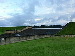
Six Mile Creek Dam spillway in 2021
Australia Queensland relief location map.jpg
Red pog.svg
Location of the Six Mile Creek Dam
in Queensland
CountryAustralia
Location South East Queensland
Coordinates 26°22′52″S152°55′48″E / 26.38111°S 152.93000°E / -26.38111; 152.93000
Purpose
StatusOperational
Opening date1965 (1965)
Operator(s) SEQ Water
Dam and spillways
Type of dam Embankment dam
ImpoundsSix Mile Creek
Height15.7 m (52 ft) [1]
Length490 m (1,610 ft) [1]
Dam volume69×10^3 m3 (2.4×10^6 cu ft) [1]
Spillway type Uncontrolled
Spillway capacity1,147 m3/s (40,500 cu ft/s) [1]
Reservoir
CreatesLake Macdonald
Total capacity8,018 ML (1.764×10⁹ imp gal; 2.118×10⁹ US gal) [2] [3]
Catchment area 49 km2 (19 sq mi) [1] [2]
Surface area260 ha (640 acres) [2] [3]
Website
www.seqwater.com.au

The Six Mile Creek Dam (more commonly known as Lake MacDonald) is a rock and earth-fill embankment dam with an un-gated spillway across the Six Mile Creek that is located in the South East region of Queensland, Australia. The main purposes of the dam are for potable water supply of the Sunshine Coast region [3] and for recreation. [1] The impounded reservoir is called Lake Macdonald, named in memory of former Noosa Shire Council Chairman Ian MacDonald. [4]

Contents

Location and features

The dam is located 6 kilometres (3.7 mi) from Cooroy and 15 kilometres (9.3 mi) west of Noosa. The small settlement of Lake MacDonald is located adjacent to the dam. The primary inflow of the reservoir is Six Mile Creek. [3]

Built in 1965 [1] and raised by 3.6 metres in 1980, the rock and earthfill dam structure is 15.7 metres (52 ft) high and 490 metres (1,610 ft) long. The 69-thousand-cubic-metre (2.4×10^6 cu ft) dam wall holds back the 8,018-megalitre (1.764×10⁹ imp gal; 2.118×10⁹ US gal) reservoir when at full capacity. From a catchment area of 49 square kilometres (19 sq mi) that includes much of the Tewantin National Park, the dam creates Lake Macdonald, with a surface area of 260 hectares (640 acres). The uncontrolled un-gated spillway has a discharge capacity of 1,147 cubic metres per second (40,500 cu ft/s). [1] [5] Initially managed by the Sunshine Coast Regional Council, management of the dam was transferred to Seqwater on 1 July 2008.

The dam reached its maximum recorded level of 1.97m over the spillway in February 2012.[ citation needed ]

In May 2019, Seqwater proposes to upgrade Six Mile Creek Dam (also known as Lake Macdonald Dam) as part of its Dam Improvement Program. [6]

Recreational activities

Within proximity of the dam, horse riding, boating and canoeing are permitted. The Noosa Botanic Gardens are located on the northwestern shoreline of Lake Macdonald.

The reservoir is stocked with Mary River cod, bass, yellowbelly, saratoga and snub nosed gar with endemic populations of tandans (eel tailed catfish) and the introduced spangled perch. [3] [7] A stocked impoundment permit is required to fish in the dam. [8]

Historical levels

Historical high water capacity percentages above 110% since recording began on 1 July 2008. [9]

DatePercentage
1 November 2017113.4
8 October 2018115.3
1 November 2020119.9
14 February 2022111.6
16 May 2022113.4
30 January 2024115.2

See also

Related Research Articles

<span class="mw-page-title-main">Somerset Dam</span> Dam in South East Queensland

The Somerset Dam is a mass concrete gravity dam with a gated spillway across the Stanley River in Queensland, Australia. It is within the locality of Somerset Dam in the Somerset Region in South East Queensland. The main purpose of the dam is the supply of potable water for the Brisbane, Gold Coast and Logan City regions. Additionally, the dam provides for flood mitigation, recreation and for the generation of hydroelectricity. The impounded reservoir is called Lake Somerset.

<span class="mw-page-title-main">Hinze Dam</span> Dam in South East Queensland

The Hinze Dam is a rock and earth-fill embankment dam with an un-gated spillway across the Nerang River in the Gold Coast hinterland of South East, Queensland, Australia. The main purpose of the dam is for potable water supply of the Gold Coast region. The impounded reservoir is called Advancetown Lake.

<span class="mw-page-title-main">Wivenhoe Dam</span> Dam in South East Queensland

The Wivenhoe Dam is a rock and earth-fill embankment dam with a concrete spillway across the Brisbane River in South East Queensland, Australia. The dam takes it names from the local Wivenhoe Pocket rural community. The dam wall is located about 80 kilometres (50 mi) by road from the centre of Brisbane. The primary purpose of the dam is the supply of potable water for the Brisbane and Ipswich regions. The dam also provides for flood mitigation control, hydroelectricity, and recreation. The impounded reservoir is called Lake Wivenhoe and the dam, the lake and a narrow strip of surrounding land forms a locality also called Lake Wivenhoe.

<span class="mw-page-title-main">Moogerah Dam</span> Dam in South East Queensland

The Moogerah Dam is a mass concrete double curvature arch dam with an un-gated spillway across Reynolds Creek in South East Queensland, Australia, now within the locality of Moogerah in the Scenic Rim Region. The main purposes of the dam are for irrigation in the Reynolds Creek district and for supply of potable water to Warrill Creek and farmers in the Warrill Valley. The impounded reservoir is called Lake Moogerah.

<span class="mw-page-title-main">Leslie Harrison Dam</span> Dam in South East Queensland

The Leslie Harrison Dam is an earth-fill embankment dam across the Tingalpa Creek that is located in the South East region of Queensland, Australia. The main purpose of the dam is for potable water supply of the Redland City in Brisbane. The impounded reservoir is called Tingalpa Reservoir. The dam was named after Robert Leslie Harrison, a Queensland parliamentarian who died in April 1966.

<span class="mw-page-title-main">Maroon Dam</span> Dam in South East Queensland

The Maroon Dam is a rock and earth-fill embankment dam with an un-gated spillway across the Burnett Creek that is located in the South East region of Queensland, Australia. The main purpose of the dam is for irrigation of the Scenic Rim Regional Council region. The impounded reservoir is also called Maroon Dam.

<span class="mw-page-title-main">North Pine Dam</span> Dam in South East Queensland

The North Pine Dam is a mass concrete gravity dam with earth-fill embankments on abutments with a gated spillway across the North Pine River that is located in the South East region of Queensland, Australia. The main purpose of the dam is for supply of potable water for the Moreton Bay region and Brisbane's northern suburbs. The impounded reservoir is called Lake Samsonvale.

<span class="mw-page-title-main">Little Nerang Dam</span> Dam in South East Queensland

The Little Nerang Dam is a concrete gravity dam with an un-gated spillway across the Little Nerang Creek that is located in the South East region of Queensland, Australia. The main purpose of the dam is for potable water supply of the Gold Coast region. The impounded reservoir is also called Little Nerang Dam. The dam was closed to the public in 2013 due to safety concerns.

The Sideling Creek Dam is an earth-fill embankment dam with an un-gated spillway across the Sideling Creek in Kurwongbah, City of Moreton Bay, Queensland, Australia. The main purposes of the dam are for potable water supply of the City of Moreton Bay and for recreation. The impounded reservoir is called Lake Kurwongbah.

<span class="mw-page-title-main">Atkinson Dam</span> Dam in South East Queensland

The Atkinson Dam is an earth-fill embankment dam across the Buaraba Creek and a naturally forming lagoon, which is located near Lowood in the South East region of Queensland, Australia. The main purpose of the dam is for irrigation of farming land in the lower Lockyer Valley. The resultant reservoir is called Lake Atkinson.

<span class="mw-page-title-main">Cooby Dam</span> Dam in Darling Downs, Queensland

The Cooby Dam is a rock–fill embankment dam with an un–gated spillway across the Cooby Creek, a tributary of Condamine River, at Groomsville in the Toowoomba Region on the Darling Downs, Queensland, Australia. The main purpose of the dam is for potable water supply of the Toowoomba region. The impounded reservoir is called the Cooby Creek Reservoir.

The Borumba Dam is a rock-fill embankment dam with an un-gated spillway located across the Yabba Creek, a tributary of the Mary River, in the Wide Bay–Burnett region of Queensland, Australia. The main purposes of the dam are for irrigation and potable water supply. The resultant impounded reservoir is called Lake Borumba.

<span class="mw-page-title-main">Wappa Dam</span> Dam in South East Queensland

The Wappa Dam is a mass concrete gravity arch dam with earth-fill abutments and an un-gated spillway across the South Maroochy River that is located in the South East region of Queensland, Australia. The main purpose of the dam is for supply of potable water for the Sunshine Coast region. The impounded reservoir is also called Wappa Dam. The dam and most of the reservoir are within Kiamba with the most northerly part of the reservoir in Cooloolabin, both in the Sunshine Coast Region.

<span class="mw-page-title-main">Bill Gunn Dam</span> Dam in South East Queensland

The Bill Gunn Dam is an earth-fill embankment dam with an un-gated spillway located off-stream in Laidley Heights in the South East region of Queensland, Australia. The main purpose of the dam is for irrigation of the Lockyer Valley. The resultant reservoir is called Lake Dyer.

The Lake Clarendon Dam is a rock and earth-fill embankment dam with an un-gated spillway located off-stream in the locality of Lake Clarendon in the Lockyer Valley Region, South East Queensland, Australia. The main purpose of the dam is for irrigation of the Lockyer Valley. The resultant impounded reservoir is called Lake Clarendon.

The Ewen Maddock Dam is an earth-fill embankment dam with an un-gated spillway across the Addlington Creek that is located in Landsborough in the South East region of Queensland, Australia. The main purpose of the dam is for potable water supply of the Sunshine Coast region.

<span class="mw-page-title-main">Baroon Pocket Dam</span> Dam in South East Queensland

The Baroon Pocket Dam is a rock and earth-fill embankment dam with an un-gated spillway across the Obi Obi Creek, in North Maleny, Sunshine Coast Region, in South East Queensland, Australia. The main purpose of the dam is for potable water supply. The impounded reservoir is called Lake Baroon.

<span class="mw-page-title-main">Splityard Creek Dam</span> Dam in South East Queensland

The Splityard Creek Dam is a rock and earth-fill embankment dam with an un-gated spillway across the Pryde Creek that is located in the South East region of Queensland, Australia. The sole purpose of the dam is for the generation of hydroelectricity. The impounded reservoir is called the Splityard Creek Reservoir.

<span class="mw-page-title-main">Coolmunda Dam</span> Dam in Queensland, Australia

The Coolmunda Dam is an earth–fill embankment dam with a gated spillway across the Macintrye Brook, a tributary of the Dumaresq River, that is located on Darling Downs in Coolmunda, Goondiwindi Region, Queensland, Australia. The main purposes of the dam are for irrigation and potable water supply. The impounded reservoir is called the Lake Coolmunda.

Lake Manchester Dam is a concrete gravity dam with an un-gated spillway across Cabbage Tree Creek. It is also known as Cabbage Tree Creek Dam. It is in the locality of Lake Manchester, City of Brisbane, Queensland, Australia. The main purpose of the dam is for potable water supply of Brisbane. The impounded reservoir is called Lake Manchester.

References

  1. 1 2 3 4 5 6 7 8 9 "Register of Large Dams in Australia". Dams information. Australian National Committee on Large Dams. 2010. Archived from the original (Excel (requires download)) on 12 December 2013. Retrieved 4 July 2014.
  2. 1 2 3 "Lake Macdonald". Water supply: Dams and weirs. Seqwater. 2014. Retrieved 4 July 2014.
  3. 1 2 3 4 5 Harrison, Rod; James, Ernie; Sully, Chris; Classon, Bill; Eckermann, Joy (2008). Queensland Dams. Bayswater, Victoria: Australian Fishing Network. ISBN   978-1-86513-134-4.
  4. Jarratt, Phil (18 August 2020). "Chairman's choice". Noosa Today. Retrieved 28 January 2021.
  5. "Lake MacDonald Dam Emergency Action Plan" (PDF).
  6. "Lake Macdonald upgrade | Seqwater". www.seqwater.com.au. Retrieved 18 December 2017.
  7. "Lake MacDonald - Cooroy. Qld". Sweetwater Fishing Australia. Garry Fitzgerald. 2000. Retrieved 4 July 2014.
  8. "Do I need a permit to go fishing in a dam?". Department of Agriculture, Fisheries and Forestry. Queensland Government. 5 February 2013. Retrieved 4 July 2014.
  9. "Historic Dam Levels". seqwater.com.au. seqwater. Retrieved 30 January 2024.