E.J. Beardmore Dam

Last updated

Beardmore Dam
BeardmoreDam.jpg
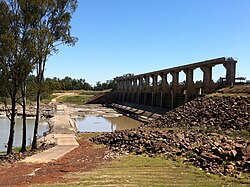
The Beardmore Dam viewed from below the dam wall
Australia Queensland relief location map.jpg
Red pog.svg
Location of the Beardmore Dam
in Queensland
Official nameE. J. Beardmore Dam
CountryAustralia
Location South West Queensland
Coordinates 27°54′22″S148°38′42″E / 27.90611°S 148.64500°E / -27.90611; 148.64500 Coordinates: 27°54′22″S148°38′42″E / 27.90611°S 148.64500°E / -27.90611; 148.64500
Purpose Irrigation; water supply
StatusOperational
Opening date1972
Operator(s) Sunwater
Dam and spillways
Type of dam Embankment dam
Impounds Balonne River
Height15.2 m (50 ft)
Length2,591 m (8,501 ft)
Dam volume115×10^3 m3 (4.1×10^6 cu ft)
Spillways One
Spillway type Uncontrolled
Spillway capacity5,550 m3/s (196,000 cu ft/s)
Reservoir
CreatesLake Kajarabie
Total capacity81,700 ML (18.0×10^9 imp gal; 21.6×10^9 US gal) [1]
Catchment area 71,560 km2 (27,630 sq mi)
Surface area2,850 ha (7,000 acres)
Maximum water depth12.1 m (40 ft)
Normal elevation207.1 m (679 ft)

The E.J. Beardmore Dam, an earth-fill embankment dam with a concrete gravity wall across the Balonne River, is located in South West Queensland, Australia. The main purpose of the dam is for irrigation. The resultant reservoir is called Lake Kajarabie.

Contents

Location and features

Located 17 kilometres (11 mi) north-east of St George, the dam wall was constructed in 1972.

The dam wall is 15.2 metres (50 ft) high and 2,591 metres (8,501 ft) long and holds back 81,700 megalitres (18.0×10^9 imp gal; 21.6×10^9 US gal) of water when at full capacity. The surface area of the reservoir is 2,850 hectares (7,000 acres) and the catchment area is 71,560 square kilometres (27,630 sq mi). The uncontrolled spillway has a discharge capacity of 5,550 cubic metres per second (196,000 cu ft/s). [2] Lake Kajarabie has an average depth of 2.4 metres (7 ft 10 in) and, when full, impounded water can back up some 75 kilometres (47 mi) along the Balonne River and almost 20 kilometres (12 mi) along the Maranoa River.

See also

Related Research Articles

Balonne River

The Balonne River, part of the Murray-Darling Basin system, is a short yet significant part of the inland river group of South West Queensland, Australia.

Somerset Dam Dam in South East Queensland

The Somerset Dam is a mass concrete gravity dam with a gated spillway across the Stanley River in Queensland, Australia. It is within the locality of Somerset Dam in the Somerset Region in South East Queensland. The main purpose of the dam is the supply of potable water for the Brisbane, Gold Coast and Logan City regions. Additionally, the dam provides for flood mitigation, recreation and for the generation of hydroelectricity. The impounded reservoir is called Lake Somerset.

Hinze Dam Dam in South East Queensland

The Hinze Dam is a rock and earth-fill embankment dam with an un-gated spillway across the Nerang River in the Gold Coast hinterland of South East, Queensland, Australia. The main purpose of the dam is for potable water supply of the Gold Coast region. The impounded reservoir is called Advancetown Lake.

Wivenhoe Dam Dam in South East Queensland

The Wivenhoe Dam is a rock and earth-fill embankment dam with a concrete spillway across the Brisbane River in South East Queensland, Australia. The dam wall is located about 80 kilometres (50 mi) by road from the centre of Brisbane. The primary purpose of the dam is the supply of potable water for the Brisbane and Ipswich regions. In addition, the dam also provides for flood mitigation control, hydroelectricity and for recreation. The impounded reservoir is called Lake Wivenhoe and the dam, the lake and a narrow strip of surrounding land forms a locality also called Lake Wivenhoe.

Moogerah Dam Dam in South East Queensland

The Moogerah Dam is a mass concrete double curvature arch dam with an un-gated spillway across the Reynolds Creek that is located in the South East region of Queensland, Australia. The main purposes of the dam are for irrigation of the Reynolds Creek and for supply of potable water to Warrill Creek and farmers in the Warrill Valley. The impounded reservoir is called Lake Moogerah.

Maroon Dam Dam in South East Queensland

The Maroon Dam is a rock and earth-fill embankment dam with an un-gated spillway across the Burnett Creek that is located in the South East region of Queensland, Australia. The main purpose of the dam is for irrigation of the Scenic Rim Regional Council region. The impounded reservoir is also called Maroon Dam.

Burdekin Dam Dam in North Queensland

The Burdekin Dam, officially the Burdekin Falls Dam, is a concrete gravity dam with an uncontrolled spillway across the Burdekin River, located south west of Ayr, and Home Hill in North Queensland, Australia. Built for the purpose of irrigation, the reservoir, called Lake Dalrymple. Burdekin Dam is managed by SunWater. Water from the reservoir is also used to replenish downstream aquifers.

Little Nerang Dam Dam in South East Queensland

The Little Nerang Dam is a concrete gravity dam with an un-gated spillway across the Little Nerang Creek that is located in the South East region of Queensland, Australia. The main purpose of the dam is for potable water supply of the Gold Coast region. The impounded reservoir is also called Little Nerang Dam. The dam was closed to the public in 2013 due to safety concerns.

William Hovell Dam Dam in Hume, Victoria

The William Hovell Dam is a rock and earth-fill embankment dam with a flip bucket chute spillway across the King River, located in the Hume region of Victoria, Australia. The purposes of the dam are for irrigation and the generation of hydroelectricity. The impounded reservoir is called Lake William Hovell

Sideling Creek Dam Dam in South East Queensland

The Sideling Creek Dam is an earth-fill embankment dam with an un-gated spillway across the Sideling Creek that is located in the South East region of Queensland, Australia. The main purposes of the dam are for potable water supply of the Moreton Bay region and for recreation. The impounded reservoir is called Lake Kurwongbah.

Cooby Dam Dam in Darling Downs, Queensland

The Cooby Dam is a rock–fill embankment dam with an un–gated spillway across the Cooby Creek, a tributary of Condamine River, at Groomsville in the Darling Downs region of Queensland, Australia. The main purpose of the dam is for potable water supply of the Toowoomba region. The impounded reservoir is called the Cooby Creek Reservoir.

Fairbairn Dam Dam in southwest of Emerald, Central Queensland

The Fairbairn Dam is an earth-filled embankment dam across the Nogoa River, located southwest of Emerald in Central Queensland, Australia. Constructed in 1972 for the primary purpose of irrigation, the impoundment created by the dam serves as one the major potable water supplies for the region and assists with some flood mitigation. Lake Maraboon with an active capacity of 1,301,000 ML (2.86×10¹¹ imp gal; 3.44×10¹¹ US gal) was formed by damming of the Nogoa River, and, in 2008, was Queensland's second largest dam. Its capacity is approximately three times larger than Sydney Harbour. Maraboon is the Aboriginal for "where the black ducks fly".

Wappa Dam Dam in South East Queensland

The Wappa Dam is a mass concrete gravity arch dam with earth-fill abutments and an un-gated spillway across the South Maroochy River that is located in the South East region of Queensland, Australia. The main purpose of the dam is for supply of potable water for the Sunshine Coast region. The impounded reservoir is also called Wappa Dam. The dam and most of the reservoir are within Kiamba with the most northerly part of the reservoir in Cooloolabin, both in the Sunshine Coast Region.

Ewen Maddock Dam Dam in South East Queensland

The Ewen Maddock Dam is an earth-fill embankment dam with an un-gated spillway across the Addlington Creek that is located in the South East region of Queensland, Australia. The main purpose of the dam is for potable water supply of the Sunshine Coast region.

Baroon Pocket Dam Dam in South East Queensland

The Baroon Pocket Dam is a rock and earth-fill embankment dam with an un-gated spillway across the Obi Obi Creek, in North Maleny, Sunshine Coast Region, in South East Queensland, Australia. The main purpose of the dam is for potable water supply. The impounded reservoir is called Lake Baroon.

Splityard Creek Dam Dam in South East Queensland

The Splityard Creek Dam is a rock and earth-fill embankment dam with an un-gated spillway across the Pryde Creek that is located in the South East region of Queensland, Australia. The sole purpose of the dam is for the generation of hydroelectricity. The impounded reservoir is called the Splityard Creek Reservoir.

Coolmunda Dam Dam in Coolmunda, Goondiwindi Region

The Coolmunda Dam is an earth–fill embankment dam with a gated spillway across the Macintrye Brook, a tributary of the Dumaresq River, that is located on Darling Downs in Queensland, Australia. The main purposes of the dam are for irrigation and potable water supply. The impounded reservoir is called the Lake Coolmunda.

Lake Manchester Dam Dam in South East Queensland

The Lake Manchester Dam is a concrete gravity dam with an un-gated spillway across the Cabbage Tree Creek that is located in the South East region of Queensland, Australia. The main purpose of the dam is for potable water supply of Brisbane. The impounded reservoir is called Lake Manchester.

Six Mile Creek Dam Dam in South East Queensland

The Six Mile Creek Dam is a rock and earth-fill embankment dam with an un-gated spillway across the Six Mile Creek that is located in the South East region of Queensland, Australia. The main purposes of the dam are for potable water supply of the Sunshine Coast region and for recreation. The impounded reservoir is called Lake Macdonald.

Southedge Dam Dam in Far North Queensland

The Southedge Dam, also known as the Lake Mitchell Dam, is an earth filled embankment dam across the Mitchell River located in Far North Queensland, Australia. Opened in 1987 as an ornamental lake, the impoundment created by the dam is called Lake Mitchell and at full supply level has an active capacity of 129,000 megalitres.

References

  1. "Beardmore Dam: Current Water Storage Information". Sunwater. Archived from the original on 28 May 2010.
  2. "Register of Large Dams in Australia" (Excel (requires download)). Dams information. Australian National Committee on Large Dams. 2010. Retrieved 23 June 2014.