
Nanango is a rural town and locality in the South Burnett Region, Queensland, Australia. In the 2021 census, the locality of Nanango had a population of 3,679 people.

The Shire of Wondai was a local government area located in the South Burnett region of Queensland, Australia, about 140 kilometres (87 mi) northwest of the capital, Brisbane. The shire covered an area of 3,577.6 square kilometres (1,381.3 sq mi), and existed as a local government entity from 1910 until 2008, when it amalgamated with several other councils in the South Burnett area to form the South Burnett Region.
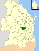
The Shire of Kingaroy was a local government area in the South Burnett region of Queensland, Australia, about 100 kilometres (62 mi) northwest of the capital, Brisbane. The shire covered an area of 2,420.3 square kilometres (934.5 sq mi), and existed as a local government entity from 1912 until 2008, when it amalgamated with several other councils in the South Burnett area to become the South Burnett Regional Council.
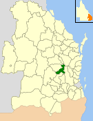
The Shire of Nanango was a local government area located in the South Burnett region of Queensland, Australia, about 100 kilometres (62 mi) northwest of the capital, Brisbane. The Shire covered an area of 1,738.4 square kilometres (671.2 sq mi), and existed as a local government entity from 1879 until 2008, when it amalgamated with several other councils in the South Burnett area to become the South Burnett Regional Council.

The Shire of Murgon was a local government area in the South Burnett region of Queensland, Australia. The shire covered an area of 664.7 square kilometres (256.6 sq mi), and existed as a local government entity from 1914 until 2008, when it amalgamated with several other councils in the South Burnett area to become the South Burnett Regional Council.
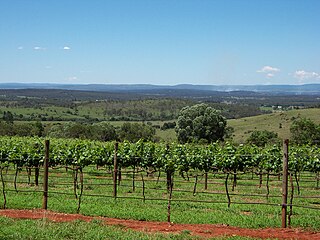
The South Burnett is a peanut growing and wine-producing area on the Great Dividing Range, north of the Darling Downs, in Queensland. It is with the basin of the Burnett River. The area is within two local government areas, South Burnett Region and Gympie Region.
Blackbutt is a rural town and locality in the South Burnett Region, Queensland, Australia. In the 2016 census, Blackbutt had a population of 836 people.

The South Burnett Region is a local government area in the South Burnett district of Queensland, Australia.

The Bjelke-Petersen Dam is a dam in Moffatdale near Cherbourg in the South Burnett Region, Queensland, Australia. The dam impounds Barker Creek and creates Lake Barambah. It is named after the Queensland Premier Joh Bjelke-Petersen. It is operated by Sunwater.

Boondooma Dam is a dam on the Boyne River on the boundary of Boondooma and Proston in the South Burnett Region of Queensland, Australia. In 1983, the dam was constructed across the Boyne River below its confluence with the Stuart River, creating Lake Boondooma.

McCauley Weir is a weir located near Nanango, Queensland, Australia. It was originally constructed as a water supply for Nanango in 1953. It has since ceased to be used as a water supply and is only used by nearby farms for stock use.
Middle Creek Dam is located at the head waters of Plane Creek west of Sarina, Queensland. It was constructed in the late 1950s-early 1960s by the Sarina Shire Council and Plane Creek Sugar Mill to augment water supply from two weirs downstream that had been built in 1926 and 1935. It has a small catchment of 7.4 square kilometres and a capacity of 1,120 megalitres. The dam is used for water skiing by the Sarina Ski Club. The dam wall and spillway were upgraded by Mackay Regional Council in 2015 to improve flood capacity.

Tingoora is a rural town and a locality in the South Burnett Region, Queensland, Australia.

Wide Bay–Burnett is a region of the Australian state of Queensland, located between 170–400 km (110–250 mi) north of the state capital, Brisbane. The area's population growth has exceeded the state average over the past 20 years, and it is forecast to grow to more than 430,000 by 2031. It is the subject of the Draft Wide Bay–Burnett Regional Plan, which aims to facilitate this growth while protecting over 90% of the region from urban development.

Harlin Rail Bridge is a heritage-listed railway bridge over Ivory Creek at Harlin, Somerset Region, Queensland, Australia. It was designed by Queensland Railways and built in 1910 by Queensland Railways. It was added to the Queensland Heritage Register on 27 November 2008. It was destroyed in 2013 as a consequence of flooding associated with Cyclone Oswald.
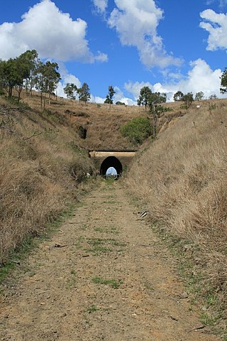
Yimbun Railway Tunnel is a heritage-listed tunnel at Sinnamons Lane, Harlin, Somerset Region, Queensland, Australia. It was designed by Queensland Railways and built from 1909 to 1910 by Queensland Railways. It was added to the Queensland Heritage Register on 27 November 2008.
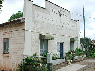
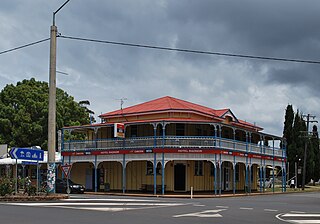
Nanango Butter Factory Building is a heritage-listed factory at George Street, Nanango, South Burnett Region, Queensland, Australia. It was built in 1927. It was added to the Queensland Heritage Register on 3 June 2005.
Nukku is a rural locality in the South Burnett Region, Queensland, Australia. In the 2016 census Nukku had a population of 22 people.
Gilla is a rural locality in the Toowoomba Region, Queensland, Australia. In the 2016 census Gilla had a population of 32 people.
Googa Creek is a rural locality in the Toowoomba Region, Queensland, Australia. In the 2016 census Googa Creek had a population of 43 people.
